
Around noon on 8 October 2026, a fire started in the Nömrög Strictly Protected Area in Khalkhgol sum, Dornod Province, Mongolia, about 27 km from the China–Mongolia border. The vehicle that caught fire belonged to Mobicom, a Mongolian mobile operator and a consolidated subsidiary 98.8% owned by KDDI1. Mobicom acknowledged that the vehicle fire spread to the grassland and said the group was there to hand over communication works for border posts and the border port and to survey local conditions2. Mongolian media reported that the convoy entered the reserve to fish for taimen; the purpose of the entry is still under police investigation3. The fire was fully extinguished on the morning of 16 October4. On 20 October the Mongolian Ministry of Environment and Climate Change put the preliminary burned area at 528,765.5 ha, of which 468,965.7 ha lies inside the reserve, 79.8% of the reserve5. ...
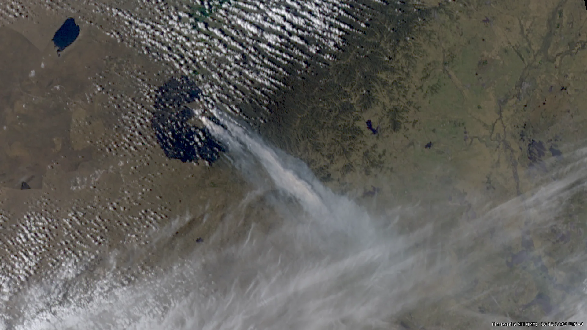
Around noon on 2026-10-08, a fire started near Nömrög (Нөмрөг; also romanised Numrug or Nomrog) in Khalkhgol soum, Dornod Province, Mongolia, about 27 km from the China–Mongolia border. Two geostationary satellites put the ignition between 11:41 and 11:51, and Mongolia’s National Emergency Management Agency (NEMA) received the call at 11:551. The Mongolian telecom operator Mobicom is a subsidiary2 of Japan’s KDDI. Its statement of 10-123 says that a vehicle caught fire while a group was handing over telecommunications work at border outposts and the Sümber border crossing and surveying local conditions, and that this started the grassland fire. The statement4 of Mongolia’s General Authority for Border Protection says the vehicle caught fire “due to the carelessness of citizens who entered the border zone”. The Dornod Province police department began investigating5 the cause of the fire on 10-17; as of 10-19 no findings have been published. The fire peaked twice, on the evening of 10-10 and during the day on 10-11, and on 10-11 and 10-12 its front reached the border west of Arxan City, Hinggan League, Inner Mongolia. After a cold front passed early on 10-12 the fire weakened. Residual burning continued intermittently inside the Mongolian fire area until the afternoon of 10-15, after which the satellites detected no more fire pixels; NEMA declared the fire fully extinguished at 07:00 on 10-166. The burned area is about 4,900 km². Montsame, quoting the Mongolian emergency services, reports that about 80% of the Nömrög Strictly Protected Area burned7; the preliminary estimate of Mongolia’s Ministry of Environment and Climate Change on 10-20 is 528,765.5 hectares, of which 468,965.7 hectares, or 79.8% of the protected area, lie inside it8. China deployed first more than 2,0009 and then more than 3,40010 personnel along the border, and its reports say the fire did not cross the border line. The satellites show no contiguous burned area extending into China. On the Sentinel-2 scenes of 10-20, 54–62 km² burned on the Chinese side within 2 km of the border, of which 34–38 km² lies within 0.5 km of the line, consistent with the hundred-metre buffer that Hinggan League counter-burned (对冲点烧, backburning toward the oncoming fire) along the border from 10-11. The parts more than 1 km from the line are concentrated in three sections: about 21 km² in the south section on the East Ujimqin Banner side, up to 3.6 km from the line, whose main patch is consistent with the backburning operations that the East Ujimqin Banner authorities reported publicly; about 11.5 km² west of Arxan, up to 2.2 km, where VIIRS fire pixels crossed the border at midday on 10-12; and about 6 km² on the east front, up to 1.7 km. The imagery cannot distinguish fire that crossed from Mongolia from backburning on the Chinese side. Smoke reached Hailar on 10-11 and Baicheng on 10-12, and the PM2.5 peaks in the two cities on those days contain smoke from this fire. This post records the accounts from the parties involved, the ignition time and the spread, the weather at the fire area, the burned area, the assessment of burning near the border, and the smoke transport. The confidence in each conclusion is listed at the end. ...
Today I ran a 12-hour simulation around Mount Fuji at 500 m resolution in the WOOF web app from Recast Systems, with boundary conditions from GFS 0.25°. I think the result is excellent: it ran on an RTX PRO 6000 (on-demand instance), took 11 minutes 40 seconds and cost 1.34 USD in total. Video demo below: https://blog-assets.ringsaturn.me/pic/2026/2026-10-10-recast-gpu-woof/recast-area-tsk-2026-10-10-1600gmt%2B9-mobile.mp4 This result surprised me somewhat. It means that in the future, if higher-resolution real-time observations become available (satellite remote sensing in particular), they could first be used to apply rapid rolling corrections to the assimilation output of large-scale models, and the corrected fields could then drive a model like WOOF, a port of WRF-ARW to the GPU. Local weather forecasting and hazard warning could improve as a result, forecasts of severe convective weather most of all. ...

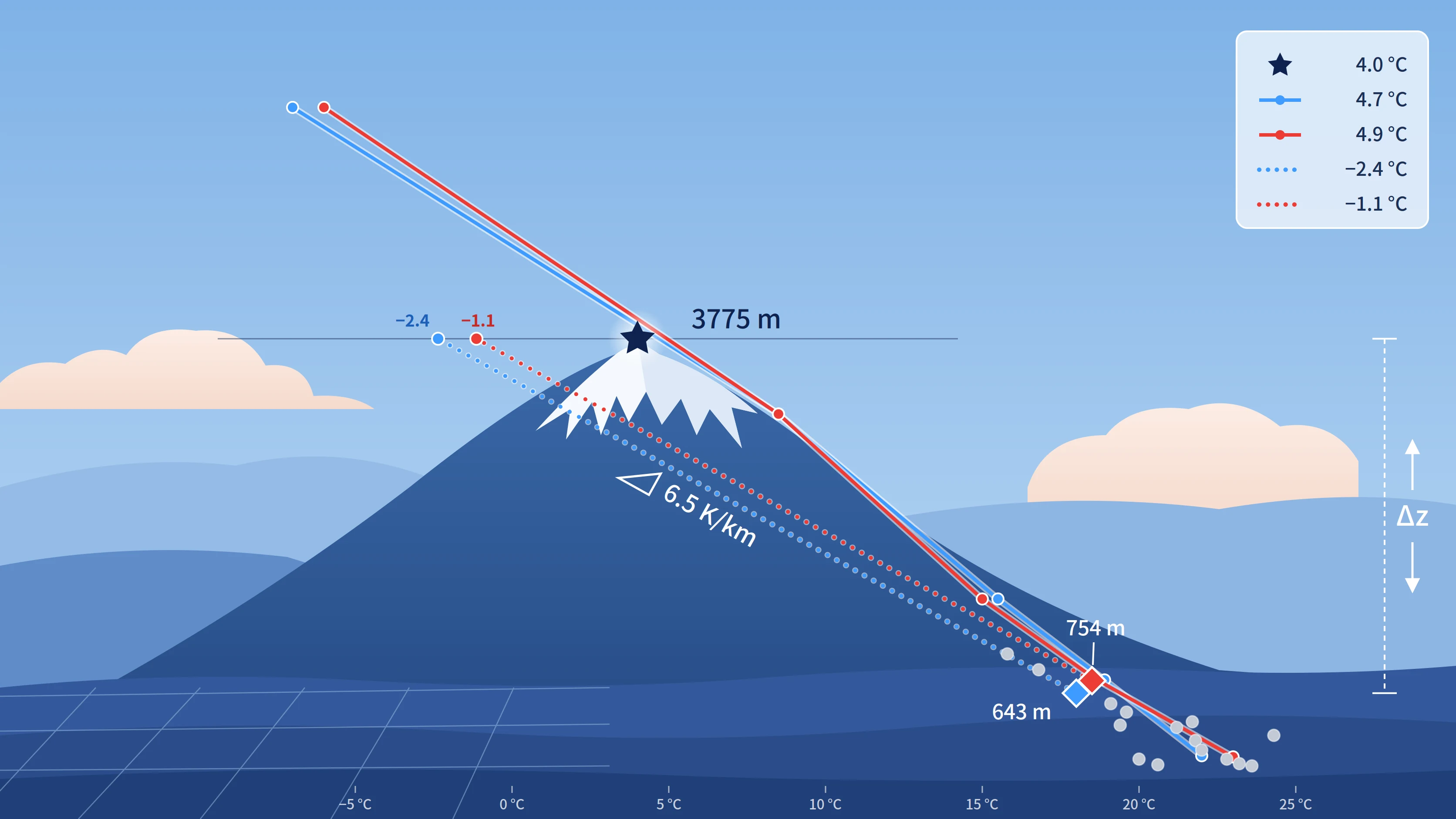
Verifying the 6.5 K/km elevation correction of GFS and ECMWF 2 m temperature against about 3000 stations over four seasons, and the pressure-level method with a decaying near-surface anomaly that xue now uses
In the previous post, 雪:更快速更流畅的气象数据动画 (Chinese), I packed forecast variables into a single-file container, .xue, which the browser read frame by frame through its index. For two variables of one GFS run, per-frame precolored PMTiles (zoom 0–4) came to 3,205.87 MB, the source GRIB2 was 137.73 MB, and .xue brought it down to about 65 MB. The size problem was solved. The problem with a custom container is that only its own decoder can read it. ...
Picking up where I left off: earlier this year I built a project called sitian, which analyzes weather processes from a sequence of synoptic charts over a period of time. Using it myself and backtesting it against historical weather, I found that combined analysis across multiple data sources did not work well. Take one example: a region is about to be affected by a typhoon, and the relevant data includes: Radiosonde soundings around the typhoon’s track Model forecast data Satellite observations Radar data Surface observations as supporting context The previous setup made it awkward to handle fairly complex combinations of input data. It also meant maintaining and integrating several data sources. So the sitian project has, in practice, stopped running. ...
ringsaturn/shachen The DEBRA algorithm (Miller et al. 2017, doi:10.1002/2017JD027365) is a method I have been following for a long time for identifying dust from satellite data. The unique aspect of this algorithm is its background estimation method, which avoids interference from special ground backgrounds such as deserts and lakebeds. Furthermore, the algorithm is designed for highly targeted engineering applications, aiming to be an all-weather recognition algorithm that provides users with fast, high-contrast output, bypassing the traditional need to introduce aerosol optical thickness.
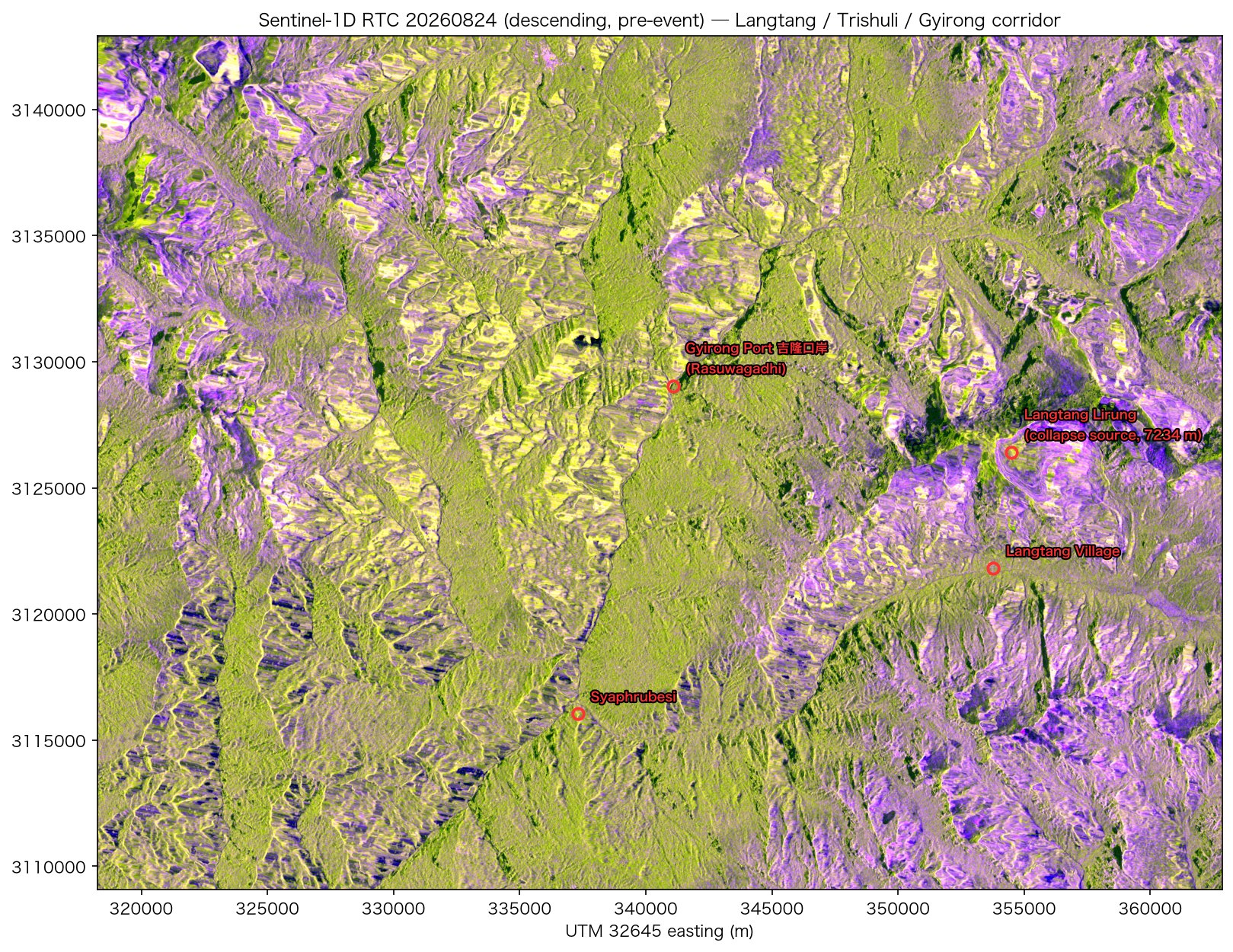
Note The satellite data in this post (Sentinel-1, NISAR and the optical scenes) was retrieved, processed and composited by the author. Claude compiled the text from those processed results and from public news reporting. Processing parameters and acquisition times are taken from the data itself; the event description and casualty figures come from the public sources linked in the text. At 02:52:10 UTC on 2026-08-26 (08:37 Nepal time, 10:52 China time), an ice and rock cliff on the north side of Langtang Lirung collapsed inside Langtang National Park. USGS located the source from seismic waves, on the north face of a peak roughly 7,200 m high; the main event released energy equivalent to M5.2, followed about 3 hours later by a secondary collapse equivalent to M4.2. AntarcticGlaciers gives the detachment coordinates as 28.2853°N, 85.5252°E and states that the present evidence does not support a glacial lake outburst flood (GLOF); the proposed mechanism is a multi-hazard cascade of ice and bedrock failure, rock/ice avalanche and debris flow, temporary river blockage, then outburst flooding. The author describes all of these as preliminary. The debris flow travelled about 100 km down the Bhote Koshi and Trishuli rivers and destroyed the customs facilities at the Rasuwagadhi border crossing along with the China–Nepal highway. The Wikipedia article records, as of 28 August, 547 dead and 977 missing on the Nepali side and 5 dead and 558 missing on the Chinese side; the search is ongoing, sources differ in what they count and when they were updated, and the figures are still changing. The same area saw a large ice and rock avalanche during the 2015 Gorkha earthquake that buried villages in the Langtang valley and killed more than 350 people. This post records the data work done in the two weeks after the event: building the Sentinel-1 pre-event baseline, processing the first obtainable post-event SAR data (NISAR, L-band) and the first post-event Sentinel-1 scene, and then the four viewing geometries that followed. ...

It has been a few years since the tzf project family was started. The last systematic look back at its development history was History of package tzf in early 2023. Since then, there have been various updates and maintenance work, mostly focused on non-core optimizations and supplementary features. In spring 2026, several long-pending important changes were finally completed: Introducing topology-aware processing to eliminate gaps and overlaps introduced during polygon simplification; Based on topology-aware processing, developing a more efficient data distribution format — ~17 MB for full-precision data and ~5.4 MB for simplified data; Introducing YStripes index acceleration, inspired by the tg project. Topology-Aware Processing The raw data is essentially a collection of polygons. Because the raw boundaries are highly detailed, the data volume is large, so polygon simplification is necessary. Many of these polygons share boundaries, but in the previous approach, each polygon was simplified independently using RDP. This caused a known issue that existed since the project’s early days: gaps appearing in areas that should be fully covered, and unwanted polygon overlaps introduced by simplification: ...