)](https://blog.ringsaturn.me/img/china-weather-radar/shanghai_wsr88d_002.jpg)
Historical Fragments of China's Meteorological Radars
Some historical fragments discovered while researching.
Some historical fragments discovered while researching.

This article introduces two major pain points in Python project maintenance\nand their solutions: 1) Passwordless publishing using PyPI’’s Trusted Publishers\nwith GitHub Actions, and 2) Ultra-fast dependency locking with the uv tool. It also\ndiscusses version management when depending on machine learning frameworks like\nPyTorch, providing specific configuration examples.\n
At work, we use uv to manage Python projects, which allows us to quickly install dependencies and lock sub-dependency versions. After returning from a period of leave, I routinely updated the packages on my computer and noticed that uv had a new version, so I updated it. However, after updating the uv.lock file in a project, I found that many wheels for dependencies had disappeared from the lock file. For example, here’s the configuration of the pyproject.toml file: ...
I want to share 2 storirs about me on handling work status: Short term remote work Get more focus time in the morning Life in Suzhou Back in the summer of 2021, my house rental was canceled by the owner, and I had to move to another place. By then, the renting prices in Beijing were too high for me to rent a house. Fortunately, I was lucky enough to book a house one month after my current house was canceled. So, I needed to find a place to live for one month. My friend decided to move to Suzhou, a city near Shanghai, which is much more affordable than Beijing. For a month, I sat in a coffee shop and worked remotely. ...

This article is reposted from Building a High-Performance Elevation API At ColorfulClouds Technology(彩云科技, “cai yun” in Pinyin for 彩云), we are committed to providing users with meteorological data at higher temporal and spatial resolutions. Over the years, we have consistently faced a challenge: due to limitations in elevation data resolution, outdoor activity enthusiasts, particularly those involved in hiking and cross-country activities, often experience noticeable discrepancies between ColorfulClouds’ data and their actual experiences. This issue is especially prominent in mountainous and plateau regions with dramatic elevation changes. ...
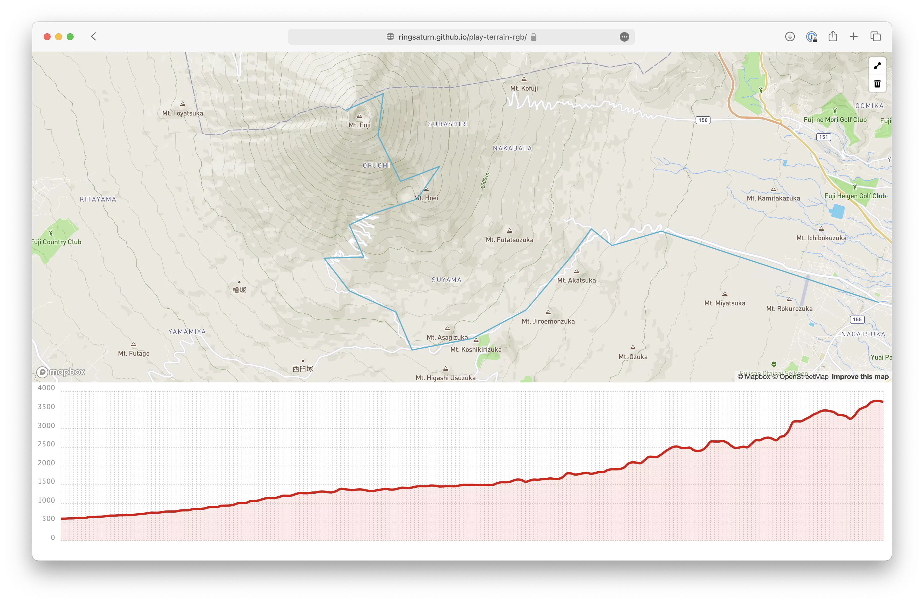
TLDR A few days ago, while searching for information, I discovered MapTiler’s elevation profile visualization page, which works excellently: This is really well done, and it’s entirely implemented in the browser https://t.co/R1vQMbdYAo pic.twitter.com/IyTYy5Fxo1 — ringsaturn.me (@ringsaturn_me) January 10, 2024 On their official blog, I found a 2019 post mentioning that the technique encodes elevation data into the RGB channels of an image and then decodes it in the browser. This allows elevation visualization directly in the browser—especially for continuous profile data—by downloading a few images to plot a continuous elevation curve. ...
Personally, I’m very disappointed about the some Python community people/projects. It’s been years that PEP 3000(the year was 2006) came up, but we need to wait years until Python 3.11(the year was 2022) to get real performance improvements? Why people keep using Python and spending lots of time to add typing which doesn’t have run time check instead of rewriting codes in Go to get huge speed up while enjoying static language’s safe static type? ...
Note ...

Introduces the evolution of tzf, from the initial implementation in Go, to the later Python extension, and finally to the current Rust implementation with a PyO3 wrapper.