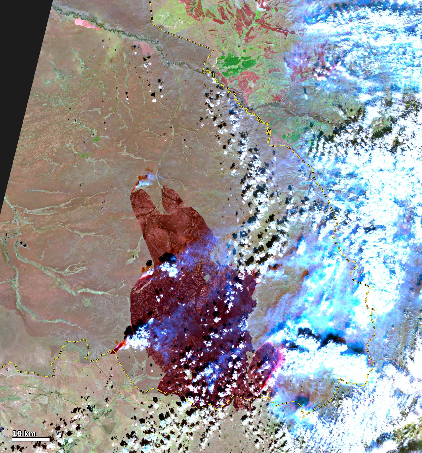
VIIRS 375 m active fire (NASA) detections accumulated hour by hour, 10-08 11:00 to 10-16 14:00 UTC+8, one frame per hour. Bright yellow: detected within 3 h; orange: 3–12 h; dark red: earlier. Lower right: total FRP per overpass. At the end the 10-16 NOAA-21 false colour (M11-I2-I1) fades in, where dark red is burn scar; yellow circles are MODIS fire detections (FIRMS) of the new fire south of the main fire on 10-15. Base map: Copernicus DEM hillshade; dashed line: border (OSM). Overpass times are L2 granule start times, a few minutes earlier than the FIRMS acquisition times used in the text and in the other fire-detection figures; the first detection, for example, is at 12:06 here and at 12:08 in FIRMS.
Around noon on 2026-10-08, a fire started near Nömrög (Нөмрөг; also romanised Numrug or Nomrog) in Khalkhgol soum, Dornod Province, Mongolia, about 27 km from the China–Mongolia border. Two geostationary satellites put the ignition between 11:41 and 11:51, the first FY-4C detection published by the National Satellite Meteorological Centre (NSMC) was at 11:501, and Mongolia’s National Emergency Management Agency (NEMA) received the call at 11:552. The Mongolian telecom operator Mobicom is a subsidiary3 of Japan’s KDDI. Its statement of 10-124 says that a vehicle caught fire while a group was handing over telecommunications work at border outposts and the Sümber border crossing and surveying local conditions, and that this started the grassland fire. The statement5 of Mongolia’s General Authority for Border Protection says the vehicle caught fire “due to the carelessness of citizens who entered the border zone”. The Dornod Province police department began investigating6 the cause of the fire on 10-17; as of 10-25 no findings have been published.
The fire peaked twice, on the evening of 10-10 and during the day on 10-11, and on 10-11 and 10-12 its front reached the border west of Arxan City, Hinggan League, Inner Mongolia. After a cold front passed early on 10-12 the fire weakened. Residual burning continued intermittently inside the Mongolian fire area until the afternoon of 10-15, after which the satellites detected no more fire pixels; NEMA declared the fire fully extinguished at 07:00 on 10-167. From the afternoon of 10-22 several new fires started in western Hulunbuir and eastern Mongolia, at least 172 km from this burn scar and unrelated to this fire; see New fires on 10-22. The burned area is about 4,900 km². Montsame, quoting the Mongolian emergency services, reports that about 80% of the Nömrög Strictly Protected Area burned8; the preliminary estimate of Mongolia’s Ministry of Environment and Climate Change on 10-20 is 528,765.5 hectares, of which 468,965.7 hectares, or 79.8% of the protected area, lie inside it9. On 10-28 the ministry set the official figure, from Sentinel-2 10 m imagery of 10-25, at 504,960.4 hectares in total (about 5,050 km²), of which 448,993.6 hectares, or 76.4% of the protected area, lie inside it10.
China deployed first more than 2,00011 and then more than 3,40012 personnel along the border, and its reports say the fire did not cross the border line. The satellites show no contiguous burned area extending into China. On the Sentinel-2 scenes of 10-20, 54–62 km² burned on the Chinese side within 2 km of the border, of which 34–38 km² lies within 0.5 km of the line, consistent with the hundred-metre buffer that Hinggan League counter-burned (对冲点烧, backburning toward the oncoming fire) along the border from 10-11. The parts more than 1 km from the line are concentrated in three sections: about 21 km² in the south section on the East Ujimqin Banner side, up to 3.6 km from the line, whose main patch is consistent with the backburning operations that the East Ujimqin Banner authorities reported publicly; about 11.5 km² west of Arxan, up to 2.2 km, where VIIRS fire pixels crossed the border at midday on 10-12; and about 6 km² on the east front, up to 1.7 km. The imagery cannot distinguish fire that crossed from Mongolia from backburning on the Chinese side. Smoke reached Hailar on 10-11 and Baicheng on 10-12, and the PM2.5 peaks in the two cities on those days contain smoke from this fire.
This post records the accounts from the parties involved, the ignition time and the spread, the weather at the fire area, the burned area, the assessment of burning near the border, and the smoke transport. The confidence in each conclusion is listed at the end.
Note
This post was written in Chinese with the help of an LLM and translated into English by Claude. Unless stated otherwise, times are China Standard Time (UTC+8).
The author has no affiliation with any of the agencies or companies mentioned in this post. This post compiles public satellite data and the public statements of the parties involved; the cause of the fire and responsibility for it rest on the findings of the Mongolian investigation. Statements are quoted as published, and quoting one does not mean this post endorses it. The figures and videos made by the author are licensed under CC BY 4.0; when reposting one on its own, credit ringsaturn, link to this post and keep the data sources named in its caption. See Reuse and License.
Fire spread animations
Two interactive replays of this fire are available on Xue:
- Fire pixels, NOAA-21 false color and GFS winds: VIIRS/MODIS fire pixels from 10-08 to 10-15, with GFS 10 m wind, gusts, temperature and dew point
- Himawari-9 10-minute infrared: 3.9 µm and 10.4 µm, 120 hours from 08:00 on 10-08, with the same fire pixels; press H in the right panel to show hotspots
Accounts from the parties involved: Mongolian agencies, Mobicom and China
Statements and interviews from the Mongolian agencies, Mobicom and KDDI, and the Chinese side, with a comparison of the accounts, are now in a separate post: Nömrög Grassland Fire in Dornod, Mongolia: Accounts from the Parties Involved. As of 10-25, the Mongolian side has published no findings on the cause.
Ignition and spread of the Nömrög fire, 10-08 to 10-15
The Nömrög fire started around noon on 2026-10-08 near 46.88°N, 119.40°E. It was weak that afternoon, flared up again on the night of 10-09, and the fire area elongated northwest–southeast. It peaked twice, on the evening of 10-10 and during the day on 10-11, and on 10-11 its eastern edge reached the border. After the cold front passed early on 10-12 it weakened, then resurged during the day at a lower intensity than on the previous two days. From 10-13 only residual burning remained in the unburned island in the middle of the fire area and along its edge, and the fire went out on the afternoon of 10-15. The table below records the sequence observation by observation.
VIIRS 375 m active fire (NASA) detections by day (days in UTC+8). Dashed line: China–Mongolia border (OSM). Grey lines: roads on the Mongolian side (solid unclassified, dotted track). Green line: Nömrög Strictly Protected Area boundary. Triangles: Sümber and Arxan border ports. Cyan star: ignition point. Roads, ports, places and the reserve boundary: OSM 2026-10-25 snapshot, © OpenStreetMap contributors (ODbL). For 10-13 daytime the only VIIRS overpass is NOAA-20. Black dots also mark an unnamed building in OSM and Хар Хоног, tagged landuse=military, 24.1 km south-southwest of the ignition point.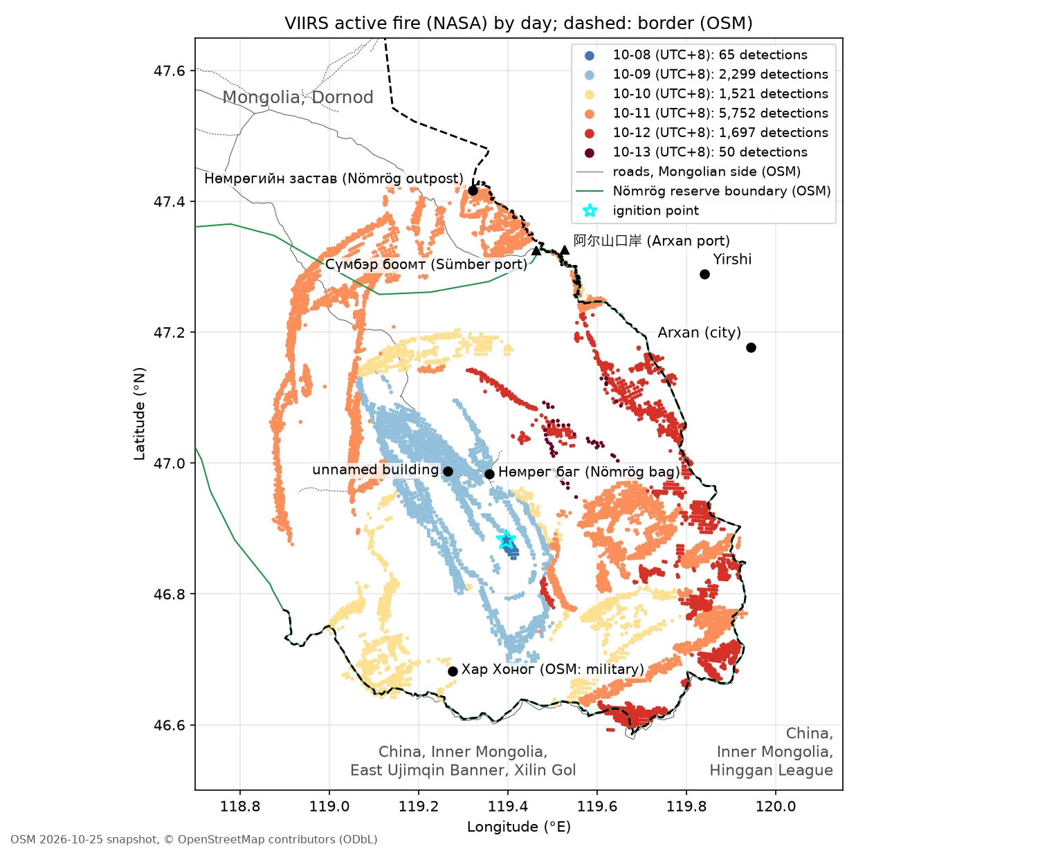
Total fire radiative power (FRP), number of fire pixels and the east and west edge longitudes of the fire detections for each polar-orbiting satellite overpass, 10-08 to the morning of 10-13 (UTC+8).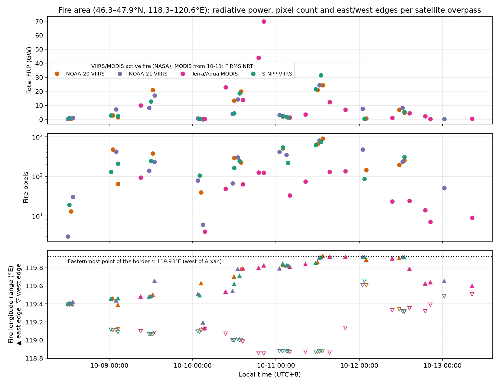
Himawari-9 10-minute hotspot time series, 10-08 to 10-13 22:00 UTC+8; grey shading is night. From the afternoon of 10-13 the fire area is under cloud.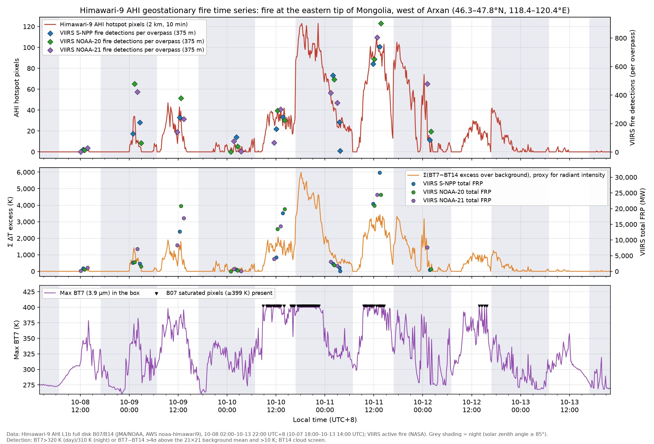
| Time (UTC+8) | Event | Source |
|---|---|---|
| 10-08 10:45–11:15 | No fire or smoke near 46.88°N, 119.40°E; maximum surface temperature about 21 °C | Landsat 9 thermal infrared, Sentinel-2C |
| 10-08 11:50–11:51 | First warming of the ignition pixel on Himawari and GK-2A, 5.9 K and 8.4 K above background; no signal on either satellite at 11:40–11:41 | Himawari, GK-2A |
| 10-08 12:08–12:10 | First detection: NOAA-21 VIIRS at 12:08 has 3 fire pixels, 236 MW, at 46.88°N, 119.39–119.40°E, with a short wisp of smoke already drifting south; first automatic Himawari detection at 12:10 | FIRMS, AHI |
| 10-08 15:00–23:00 | No Himawari hotspots: weak fire in the afternoon, cloud at night | AHI |
| 10-09 00:10–02:30 | Nighttime resurgence, 130–480 fire pixels per overpass; the fire area elongates northwest–southeast, and its northwest end reaches 47.06°N, 119.11°E | FIRMS |
| 10-09 08:00–13:00 | Daytime peak, total FRP 13–21 GW; the eastern edge reaches 119.5–119.65°E, 5–9 km from the border | FIRMS, AHI |
| 10-10 11:05 | Three fire lines on the 10 m Sentinel-2 image: a flaming line about 15 km long on the southeast flank, with its southern end at the border; a convective smoke column at the northwest head; and a wedge-shaped fire band at the southwest corner that reaches a bend in the border | Sentinel-2 |
| 10-10 17:50–22:20 | Main peak: 123 Himawari hotspots, B07 saturated at about 400 K; MODIS nighttime FRP of 44–70 GW per overpass | AHI, MODIS |
| 10-11 11:00–14:00 | Second peak: 620–900 fire pixels per VIIRS overpass, total FRP 21–31 GW; the eastern edge reaches 119.93°E, on the border | FIRMS, AHI |
| Around 10-12 01:00 | Cold front passes, the wind turns northwest, and hotspots drop sharply; 1–2 mm of precipitation | AHI, FIRMS |
| 10-12 11:45–14:35 | Daytime resurgence, weaker than on the previous two days: 196–305 fire pixels per overpass, total FRP 4.9–8.2 GW; the main fire line runs along the border west of Arxan, 13–17 km from Arxan | FIRMS |
| 10-12 14:35–20:40 | Aqua has 24 fire pixels at 14:35, and MODIS has 14 at 19:00 and 7 at 20:40; after 14:35 all fire pixels are inside the Mongolian fire area, more than 5 km from the border | FIRMS |
| 10-12 16:50–19:40 | Evening hotspot count is 1/3 to 1/4 of that in the same period on the previous two days; the eastern part burns out, and residual burning is concentrated in the western half of the fire area | AHI |
| 10-12 17:00–10-13 05:00 | Himawari nighttime average of 9.9 hotspot pixels, compared with 77 and 41 on the previous two nights; 0.4 from 02:00 to 05:00 | AHI |
| 10-13 00:45 | NOAA-21 nighttime overpass: 50 fire pixels, total FRP 0.32 GW; the same overpass the night before had 480 pixels and 7.6 GW | FIRMS |
| 10-13 daytime | Terra at 08:35 has 9 fire pixels, total FRP 0.45 GW; NOAA-20 at 11:30 has 18 fire pixels, 178 MW, 0 on the Chinese side; from 13:20 the fire area is cloud-covered | FIRMS, AHI |
| 10-14 | Four nighttime VIIRS overpasses with 3–9 fire pixels and 8–32 MW each; four daytime overpasses with 10–20 pixels and 245–456 MW each; in the afternoon S-NPP at 14:12 has 31 pixels and 901 MW, Aqua at 14:14 has 6 pixels and 1.28 GW, and 1 pixel remains at 15:52; most are in the northern half of the unburned island, at least 7.9 km from the border | FIRMS |
| 10-15 | Three nighttime VIIRS overpasses with 5–8 fire pixels and 23–74 MW each; Sentinel-2C at 11:05 shows 5 clusters of active-fire pixels on the southern edge of the unburned island; three midday VIIRS overpasses with 9–18 pixels and 88–339 MW each, with the fire pixels moved to the southeastern edge of the unburned island, at least 9.7 km from the border; the last fire pixels are 1 pixel, 4 MW, from S-NPP at 13:48 and 4 pixels, 113 MW, from Aqua at 14:52 | FIRMS, Sentinel-2, VIIRS L2 |
| 10-15 14:52–19:19 | A separate small fire on the Chinese side, about 12 km south of the main fire: Aqua at 14:52 with 1 pixel and 14 MW, and Terra at 19:19 with 2 pixels and 159 MW; on the 10-16 imagery, a new burn scar about 7 km long | FIRMS, GIBS |
| 10-15 14:00–10-18 20:23 | No fire pixels at the main fire: about 30 VIIRS overpasses, and MODIS through 10-18 20:23, detected nothing; the fire area was clear on 10-16 and cloudy on 10-17 | VIIRS L2, FIRMS, GIBS |
Ignition time and the early fire
The two high-resolution images closest to ignition both show no fire: Landsat 9 at 10:45 (30 m, with thermal infrared) and Sentinel-2C at 11:15 (10 m). No other polar-orbiting satellite passed over between 11:15 and 12:08. During that interval only two geostationary satellites observed the area: Himawari-9 and GK-2A of the Korea Meteorological Administration (128.2°E). Both have 2 km fire channels and take one frame every 10 minutes. The two satellites view the area from different angles, so their observations of the ignition pixel are independent.
GK-2A 3.8 µm brightness temperature (2 km), 10-08 11:41–12:21 UTC+8. Numbers give how far the ignition pixel is above the surrounding background: at 11:41 the ignition pixel is 298.6 K against a background of 297.6 ± 2.0 K, at 11:51 it is 306.2 K and at 12:21 331.3 K. Cyan star: ignition point; dashed line: border (OSM). Native satellite projection.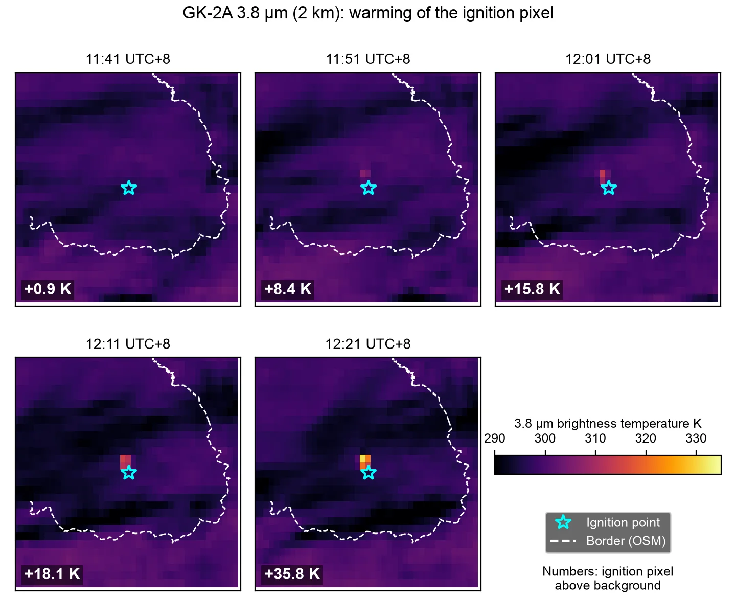
GK-2A 0.64 µm visible (0.5 km), 10-08 11:41–12:11 UTC+8. Near the ignition point there are only thin cirrus streaks. The albedo within 1.5 km of the ignition point is 0.129–0.140, less than 0.01 different from the 2–8 km ring, so no smoke plume can be made out.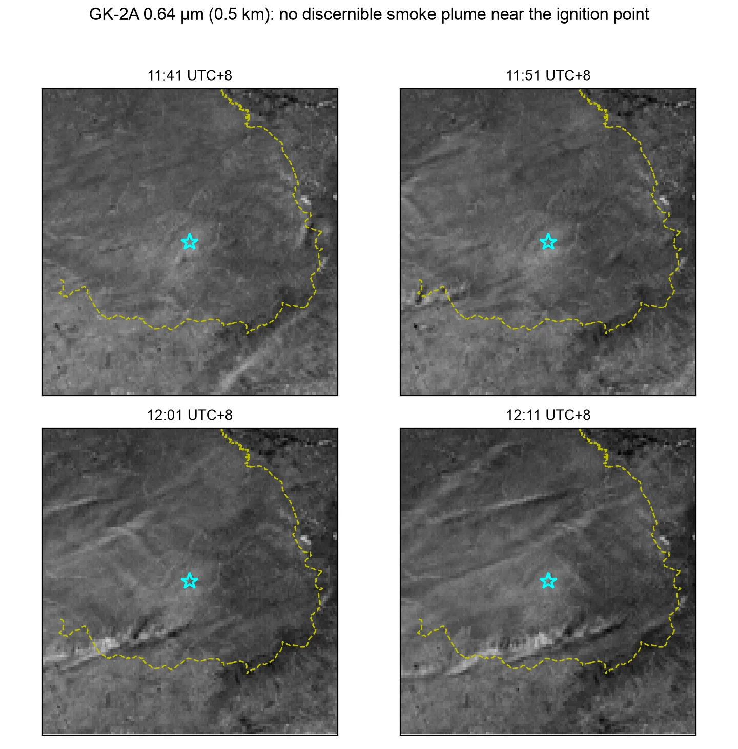
| Time (UTC+8) | Observation | Ignition pixel |
|---|---|---|
| 10:45 | Landsat 9, 30 m, with thermal infrared | No fire or smoke |
| 11:15 | Sentinel-2C, 10 m | No fire or smoke |
| 11:40–11:41 | Himawari, GK-2A | Both about 1 K above background, within noise |
| 11:50–11:51 | Himawari, GK-2A | 5.9 K and 8.4 K above background; for GK-2A, more than 3 times the background spread |
| 11:50 | FY-4C (published by NSMC) | Fire pixel, 119.40°E, 46.87°N1 |
| 12:00–12:01 | Himawari, GK-2A | Both about 16 K above background |
| 12:08 | NOAA-21 VIIRS, 375 m | 3 fire pixels, 236 MW; a wisp of smoke about 3–4 km long already extends south |
| 12:10 | Himawari | First automatic detection |
- The ignition time is therefore narrowed to 11:41–11:51 on 10-08. A 2 km pixel is insensitive to a very small early fire, so the geostationary satellites cannot show whether a very small open flame already existed around 11:40.
- In the Himawari frame at 12:00, the ignition pixel was already about 14 K above background, and all other conditions of the contextual test were met. The only reason the pixel was not selected was that its B07 brightness temperature, 309.94 K, was 0.06 K below the 310 K candidate threshold. The first automatic detection was therefore delayed to 12:10.
- Inference: by 12:08 the smoke had drifted 3–4 km south. With the surface wind of 3–4 m/s at the time of ignition, smoke takes about 15–20 minutes to drift that far. Working back from 12:08 puts the ignition at about 11:45–11:50, consistent with the two geostationary satellites.
- In the Himawari and GK-2A visible bands there are only thin cirrus streaks near the ignition point, and no smoke plume can be distinguished.
- On 10-09 NSMC published on its FY Emergency Support page that FY-4C detected a fire pixel at 119.40°E, 46.87°N at 03:50 UTC on 10-08 (11:50 UTC+8)1. The time and position agree with the table above, and the detection is 20 minutes earlier than the first automatic Himawari detection. The page also gives a time series of fire pixel area from 12:00 on 10-08 to 10:00 on 10-09, the fire pixel duration, and thematic maps of the spatial and temporal distribution.
The first three VIIRS overpasses after ignition:
The first three VIIRS overpasses after ignition, one per row. Left: wide view (true colour for NOAA-21, I1 visible for the others). Middle: I3/I2/I1 false colour, zoomed. Right: I4 fire channel with VIIRS active fire (NASA) detections. Cyan star: ignition point; dashed line: border (OSM). Middle column: white dot, Нөмрөг баг (Nömrög bag); white square, end of the OSM track nearest the ignition point (OSM 2026-10-25 snapshot, © OpenStreetMap contributors (ODbL)).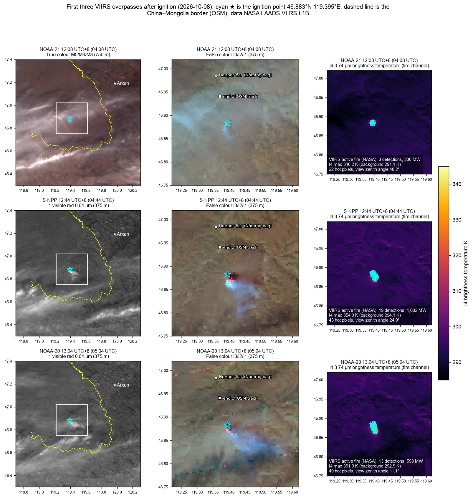
| Time (UTC+8) | Satellite | FIRMS fire pixels / FRP | Hot area | Smoke plume |
|---|---|---|---|---|
| 12:08 | NOAA-21 | 3 / 236 MW | About 1.6 × 1.6 km | About 3–4 km, toward the south |
| 12:44 | S-NPP | 19 / 1,032 MW | About 2.8 × 1.8 km | About 13 km, toward the south, slightly east |
| 13:04 | NOAA-20 | 13 / 593 MW | About 3.1 × 2.1 km | About 15 km, toward the east-southeast |
- The hot area is defined as the pixels where I4 is more than 15 K above the background within 13 km of the ignition point. Within an hour the hot area stretched north–south to about 3 km, and its main part moved south and slightly east of the ignition point. The smoke plume grew from about 4 km to about 15 km, and its direction turned from south to east-southeast.
- In all three overpasses the hot area and the smoke plume were on the Mongolian side, and the plume tip was more than 20 km from the border. The smoke did not reach the Chinese side at midday on the day of ignition.
- The few single-pixel horizontal lines in the NOAA-20 false color are detector striping and do not affect the assessment.
Surface observations at the time of ignition: Arxan station (50727, about 52 km northeast of the ignition point) and the Mongolian station Khalkh-Gol (44313, about 101 km northwest) both reported north to northwest winds of 3–4 m/s, temperatures of 10–14 °C, relative humidity of 34–46% and no weather phenomena from 11:00 to 14:00 on 10-08. With this wind direction, smoke drifts south and southeast, consistent with the plume direction seen by VIIRS. Station 44313 was drier the day before: at 14:00 on 10-07 it had a south wind of 8 m/s, 21.8 °C and 21% relative humidity.
Residual burning and extinction, 10-13 to 10-15
Fire detections from 10-13 daytime to 10-14 morning (VIIRS 375 m active fire (NASA); MODIS 1 km from FIRMS) over the 10-12 NOAA-21 burn scar (grey). Dashed line: China–Mongolia border (OSM). The white area in the middle of the fire area is the unburned island; all fire detections are on the Mongolian side.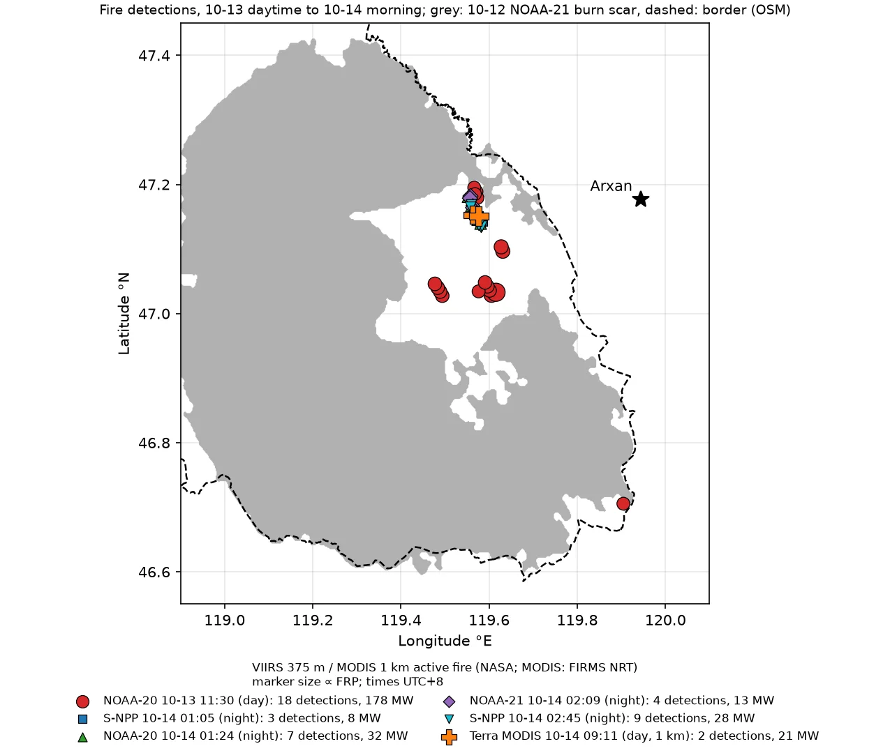
The daytime S-NPP and NOAA-21 fire data of 10-13 (00–11 UTC) were still absent from the NASA LANCE near-real-time archive as of 10-19, and the standard product has not been released either; the only daytime overpass that day is NOAA-20 at 11:30, with 18 fire pixels and 178 MW, all on the Mongolian side.
| Time (UTC+8) | Satellite | Fire pixels | Total FRP (MW) | On Chinese side | Extent | Min. distance to border (km) | Min. distance to Arxan (km) |
|---|---|---|---|---|---|---|---|
| 10-13 11:30 | NOAA-20, day | 18 | 178 | 0 | 46.71–47.20°N, 119.48–119.91°E | 1.2 | 25.4 |
| 10-14 01:05 | S-NPP, night | 3 | 8 | 0 | 47.14–47.16°N, 119.57–119.58°E | 9.6 | 27.6 |
| 10-14 01:24 | NOAA-20, night | 7 | 32 | 0 | 47.14–47.18°N, 119.55–119.58°E | 7.1 | 27.7 |
| 10-14 02:09 | NOAA-21, night | 4 | 13 | 0 | 47.16–47.18°N, 119.56°E | 6.9 | 28.9 |
| 10-14 02:45 | S-NPP, night | 9 | 28 | 0 | 47.13–47.17°N, 119.56–119.58°E | 8.4 | 27.7 |
| 10-14 09:11 | Terra, day | 2 | 21 | 0 | 47.15°N, 119.56–119.58°E | 9.8 | 28.0 |
| 10-14 11:55 | NOAA-21, day | 20 | 245 | 0 | 47.07–47.17°N, 119.50–119.58°E | 8.0 | 28.1 |
| 10-14 12:32 | S-NPP, day | 20 | 452 | 0 | 47.08–47.17°N, 119.50–119.58°E | 7.9 | 27.9 |
| 10-14 12:53 | NOAA-20, day | 14 | 252 | 0 | 47.07–47.17°N, 119.50–119.59°E | 8.1 | 27.8 |
| 10-14 13:36 | NOAA-21, day | 10 | 456 | 0 | 47.08–47.17°N, 119.50–119.59°E | 8.3 | 27.4 |
| 10-14 14:12 | S-NPP, day | 31 | 901 | 0 | 47.07–47.17°N, 119.50–119.60°E | 8.6 | 26.7 |
| 10-14 14:14 | Aqua, day | 6 | 1,278 | 0 | 47.11–47.15°N, 119.54–119.59°E | 9.2 | 27.0 |
| 10-14 15:52 | Aqua, day | 1 | 63 | 0 | 47.11°N, 119.60°E | 11.0 | 27.3 |
| 10-15 01:49 | NOAA-21, night | 7 | 49 | 0 | 47.12–47.16°N, 119.51–119.53°E | 10.3 | 31.9 |
| 10-15 02:26 | S-NPP, night | 8 | 74 | 0 | 47.12–47.16°N, 119.51–119.53°E | 10.3 | 31.9 |
| 10-15 02:45 | NOAA-20, night | 5 | 23 | 0 | 47.12–47.16°N, 119.51–119.52°E | 10.4 | 32.4 |
| 10-15 12:14 | S-NPP, day | 9 | 88 | 0 | 47.07–47.16°N, 119.51–119.62°E | 9.7 | 26.3 |
| 10-15 12:32 | NOAA-20, day | 18 | 339 | 0 | 47.06–47.10°N, 119.56–119.62°E | 11.1 | 26.5 |
| 10-15 13:16 | NOAA-21, day | 11 | 96 | 0 | 47.06–47.08°N, 119.57–119.63°E | 11.9 | 27.2 |
| 10-15 13:48 | S-NPP, day | 1 | 4 | 0 | 47.07°N, 119.62°E | 11.8 | 26.2 |
| 10-15 14:52 | Aqua, day | 4 | 113 | 0 | 47.06–47.08°N, 119.61–119.63°E | 11.4 | 26.6 |
Day-to-day change for the same satellite and the same overpass: NOAA-20 daytime from 10-12 to 10-15 is 196 pixels/6,925 MW, 18/178, 14/252 and 18/339; Terra morning on 10-13 and 10-14 is 9/448 and 2/21; NOAA-21 nighttime from 10-13 to 10-15 is 50/317, 4/13 and 7/49.
The 18 daytime NOAA-20 pixels on 10-13 fall into four groups: 8 at 47.03–47.10°N, 119.58–119.63°E, 5 at 47.18–47.20°N, 119.57°E, 4 at 47.03–47.05°N, 119.48–119.49°E, and 1 at 46.706°N, 119.905°E. The last is in the southeastern corner of the fire area, inside burn scar that already existed on 10-12, on the Mongolian side, 1.2 km from the border.
Fire detections from 10-14 daytime to 10-15 afternoon (VIIRS 375 m active fire (NASA); MODIS 1 km from FIRMS; marker size ∝ FRP) over the 10-14 NOAA-20 burn scar (grey). Dashed line: China–Mongolia border (OSM). All fire detections are on the Mongolian side, most of them inside the unburned island in the middle of the fire area; one S-NPP detection of 10-14 14:12, near 119.50°E, 47.07°N, lies on burn scar outside it. For the S-NPP overpass of 10-15 13:48 (marked *) the time is the start of the satellite data file.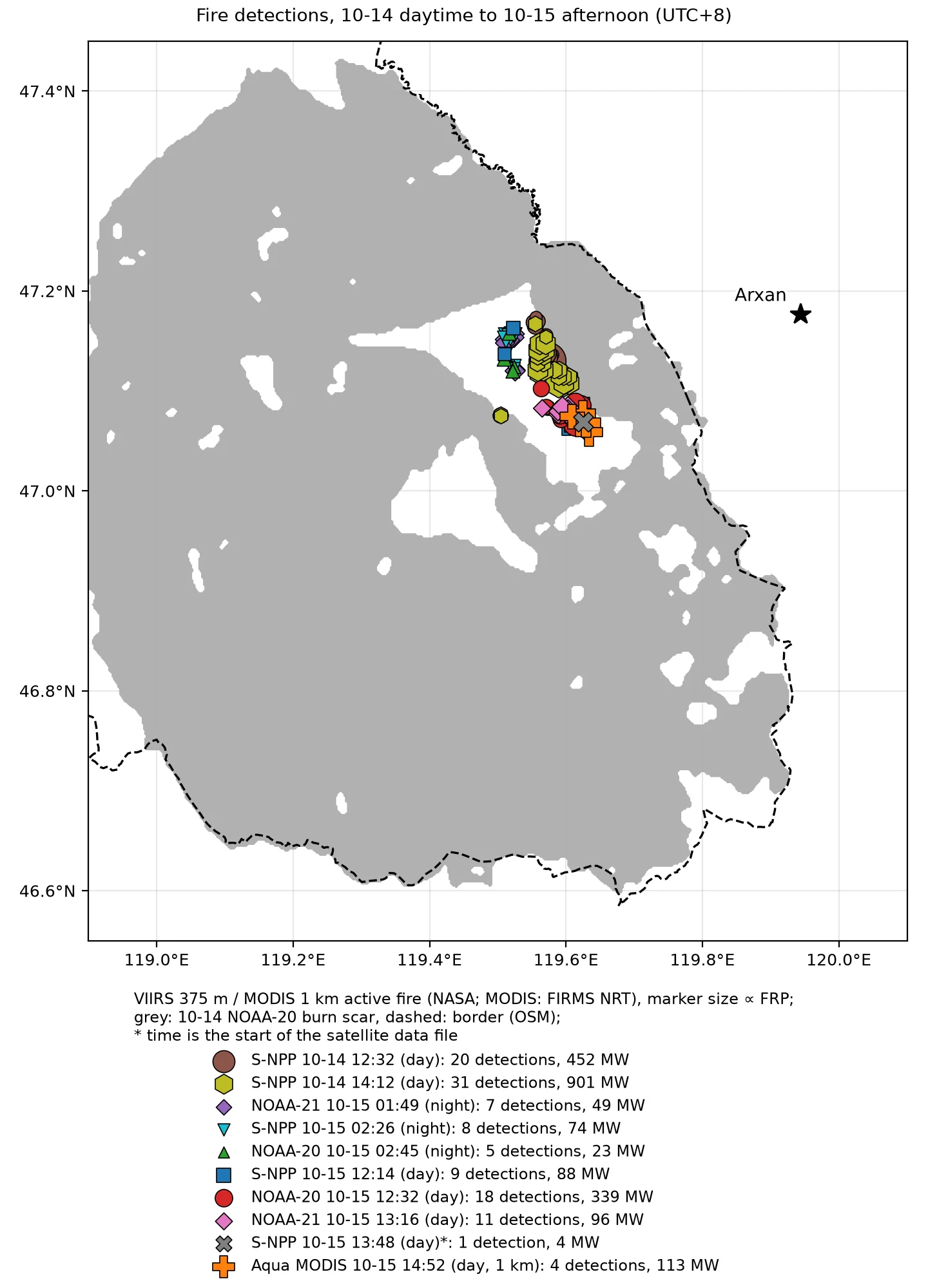
S-NPP at 14:12 on 10-14 had 31 pixels and 901 MW. Aqua at 14:14 had 6 pixels of 72–355 MW each, with confidence values of 44–93. Most were in the northern half of the unburned island, and 1 S-NPP pixel was on burn scar outside the unburned island, at about 47.07°N, 119.50°E. All were on the Mongolian side. This Aqua overpass was at the edge of the swath, with pixels of about 3.9 × 1.8 km, so its FRP has a larger uncertainty. In the same period the fire area was clear on Himawari (cloud fraction over the core 0–0.03). Each frame had 0–3 pixels with a 3.9 µm brightness temperature above 320 K, with a maximum of 348 K (13:30) against a background of about 285–297 K. This indicates sustained small-scale open flame in the afternoon, much smaller than during the day on 10-12.
The three VIIRS nighttime overpasses early on 10-15 (NOAA-21 at 01:49, S-NPP at 02:26, NOAA-20 at 02:45) each had 5–8 pixels and 23–74 MW at the same location. They were in the northwest of the unburned island, at 47.12–47.16°N, 119.51–119.53°E, 10.3–14.3 km from the border.
At midday on 10-15 the fire pixels moved to the southeastern edge of the unburned island. Aqua at 14:52 had 1 more pixel at the southern edge of the check box, at 46.499°N, 119.517°E, on the Chinese side. It is about 12 km from the southern edge of the main burn scar and about 60 km from that day’s residual burning. It belongs to a separate fire and is not included in the table above; see below.
When Sentinel-2C passed over at 11:05 on 10-15, the southern edge of the unburned island was visible through a gap in the cloud:
Sentinel-2C, 10-15 11:05 UTC+8, southern edge of the unburned island (47.04–47.12°N, 119.54–119.65°E). Left: true colour (10 m); right: SWIR false colour (B12/B8A/B4, 20 m). Red crosses: clusters of saturated SWIR pixels; other symbols: FIRMS fire detections from the same midday.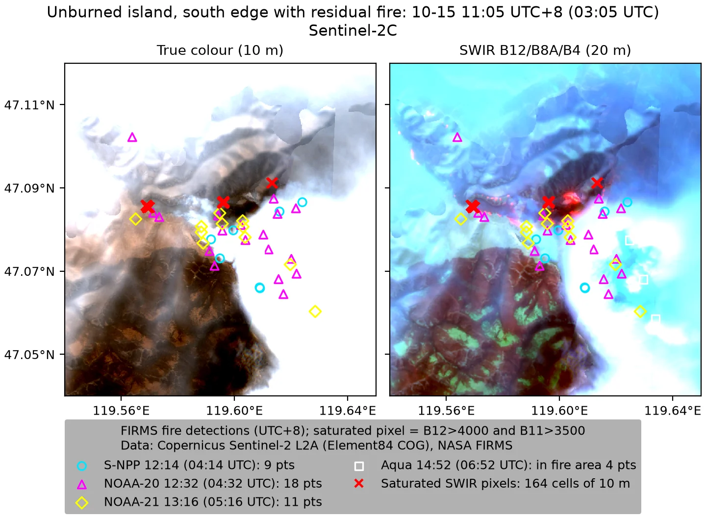
- There are 5 clusters of saturated SWIR pixels, 164 cells of 10 m in total. Their centers are at 47.0842°N, 119.5717°E (82 cells), 47.0853°N, 119.5697°E (44 cells), 47.0838°N, 119.5753°E (18 cells), 47.0865°N, 119.5961°E (17 cells) and 47.0912°N, 119.6133°E (3 cells). B12 reflectance is 1.2–1.6, above the upper limit for surface reflectance, so these are open flames.
- The five clusters are spread east–west along 47.084–47.091°N, from 119.570°E to 119.613°E, over about 3.3 km. They lie at the boundary between the black old burn scar to the south and unburned grass to the north, and smoke is visible in the true color image.
- They are 0.03–0.42 km from the fire pixels of the three VIIRS overpasses that midday and 11.2–14.2 km from the border.
- Inference: the fire line on the southern edge of the unburned island was burning north into the unburned grass and was still burning at 11:00 on 10-15. The northern half of the unburned island is cloud-covered, so whether there was fire there cannot be seen.
- The core box of the unburned island (47.04–47.20°N, 119.48–119.66°E) is only 9% clear, and pixels that are clear in both this scene and the 10-13 scene make up only 2.7%. This scene therefore cannot quantify whether the burn scar inside the unburned island grew.
After midday on 10-15 the number of fire pixels decreased with each overpass. NOAA-21 at 13:16 still had 11 pixels and 96 MW. S-NPP at 13:48 had only 1 pixel, 4 MW, at 47.069°N, 119.625°E, 11.8 km from the border; this is the last VIIRS fire pixel of this fire. The 4 Aqua pixels at 14:52, 113 MW, are the last fire pixels of the main fire. From 14:00 on 10-15 to 14:00 on 10-18, S-NPP, NOAA-20 and NOAA-21 made about 30 overpasses of the fire area, day and night, without a single fire pixel. MODIS had none through 20:23 on 10-18. The fire area was clear during the three VIIRS overpasses on 10-16, cloud-covered on 10-17, and clear over its western half on 10-18. The zero detections on 10-16 were obtained under clear sky, and on that basis the main fire is judged to have gone out on the afternoon of 10-15.
Separate fire south of the main fire
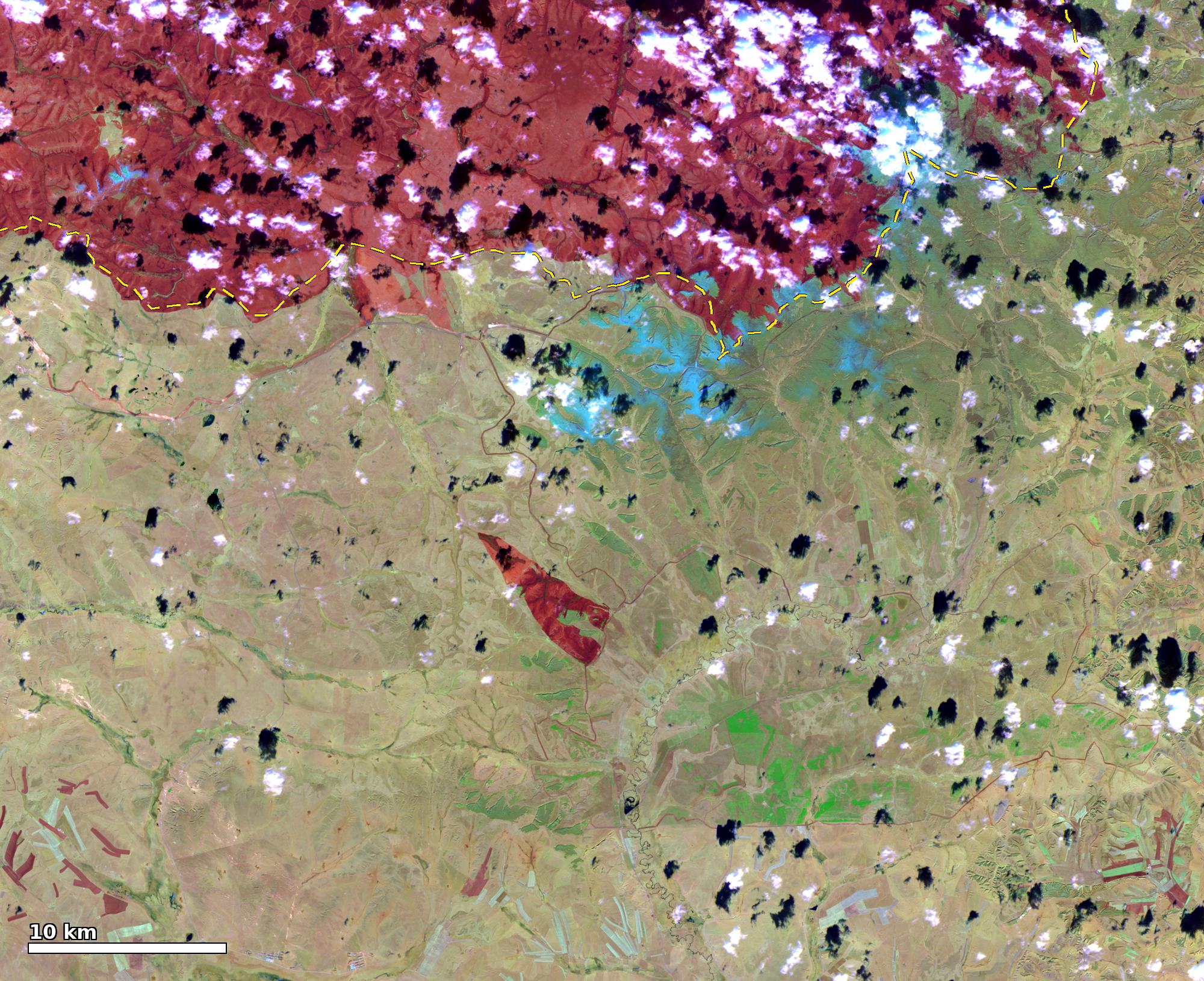
VIIRS false colour (M11-I2-I1) from NOAA-20 on 10-14 and NOAA-21 on 10-16, 46.3–46.75°N, 119.2–120.0°E. The dark red area at the top is the burn scar of the main fire. Cyan circles: MODIS fire detections from Aqua at 14:52 and Terra at 19:19 UTC+8 on 10-15; yellow line: border (OSM). On 10-16 a new burn scar, absent on 10-14, lies between the two groups of fire detections.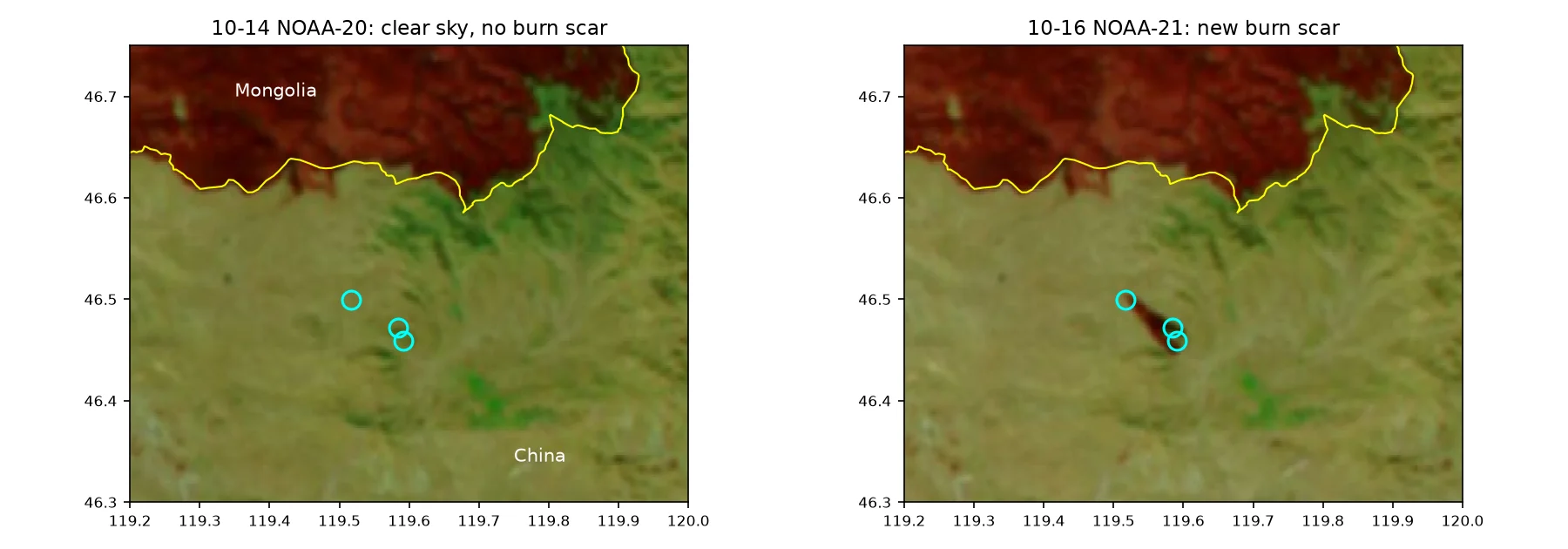
At the Aqua overpass at 14:52 on 10-15 there was 1 fire pixel south of the main fire, at 46.499°N, 119.517°E, 14 MW, on the Chinese side, 13.6 km from the border. That evening Terra at 19:19 had 2 fire pixels about 6 km to its southeast, at 46.459–46.472°N, 119.584–119.591°E, with FRP of 49 MW and 110 MW, 14.5–15.5 km from the border. By a reverse lookup of OpenStreetMap place names, this location is in Mandubaolige town, East Ujimqin Banner, Xilin Gol League.
- VIIRS did not detect this fire. The daytime VIIRS overpasses on 10-15 were at 12:14–13:48, and the nighttime overpasses started at 01:30 on 10-16. None of them had fire pixels here.
- On 10-14 this area was clear, and the imagery shows no burn scar; on 10-15 it was cloudy. All three scenes on 10-16 show a new northwest–southeast burn scar whose two ends correspond to the Aqua and Terra fire pixels. It is about 7 km long, spans 46.45–46.50°N, 119.52–119.59°E, lies entirely on the Chinese side, and is about 12 km from the southern edge of the main burn scar.
- The area is about 10 km² in the NOAA-21 scene and about 4.5 km² in the S-NPP scene. The burn scar is only a few VIIRS pixels wide and its edge error is large, so the area is given as 5–10 km². Confirming it requires 10 m imagery.
- Inference: this is a separate ignition. It started after the S-NPP overpass at 13:48, and the fire burned about 7 km from northwest to southeast before 19:19. That day the residual burning of the main fire was at 47.06–47.10°N, about 60 km away, and this distance makes spotting from the main fire unlikely. The cause is unknown.
The separate burn scar south of the main fire, Sentinel-2B on 10-20: SWIR false colour and dNBR (10-05→10-20); black: patches with dNBR > 0.20.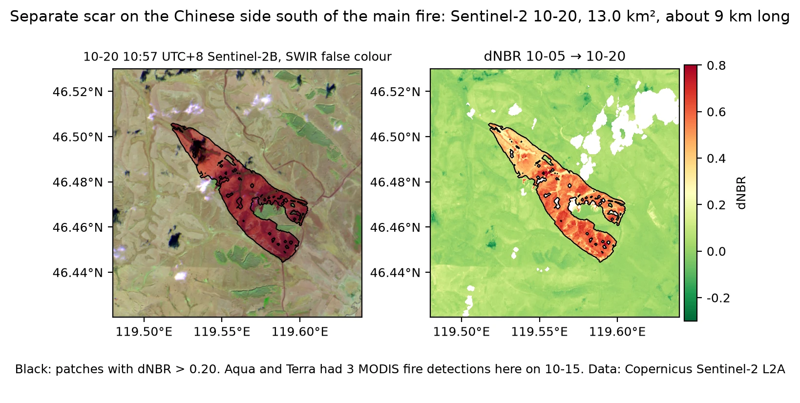
Sentinel-2B at 10:57 on 10-20 is clear here. On the 20 m dNBR the scar is a band running from northwest to southeast, 46.445–46.506°N, 119.517–119.605°E, about 9 km long and 0.5–1.5 km wide, with an area of 13.0 km² (12.3 km² at a threshold of 0.27), entirely on the Chinese side and 14.7–17.1 km from the border. Its two ends coincide with the Aqua and Terra fire pixels of 10-15.
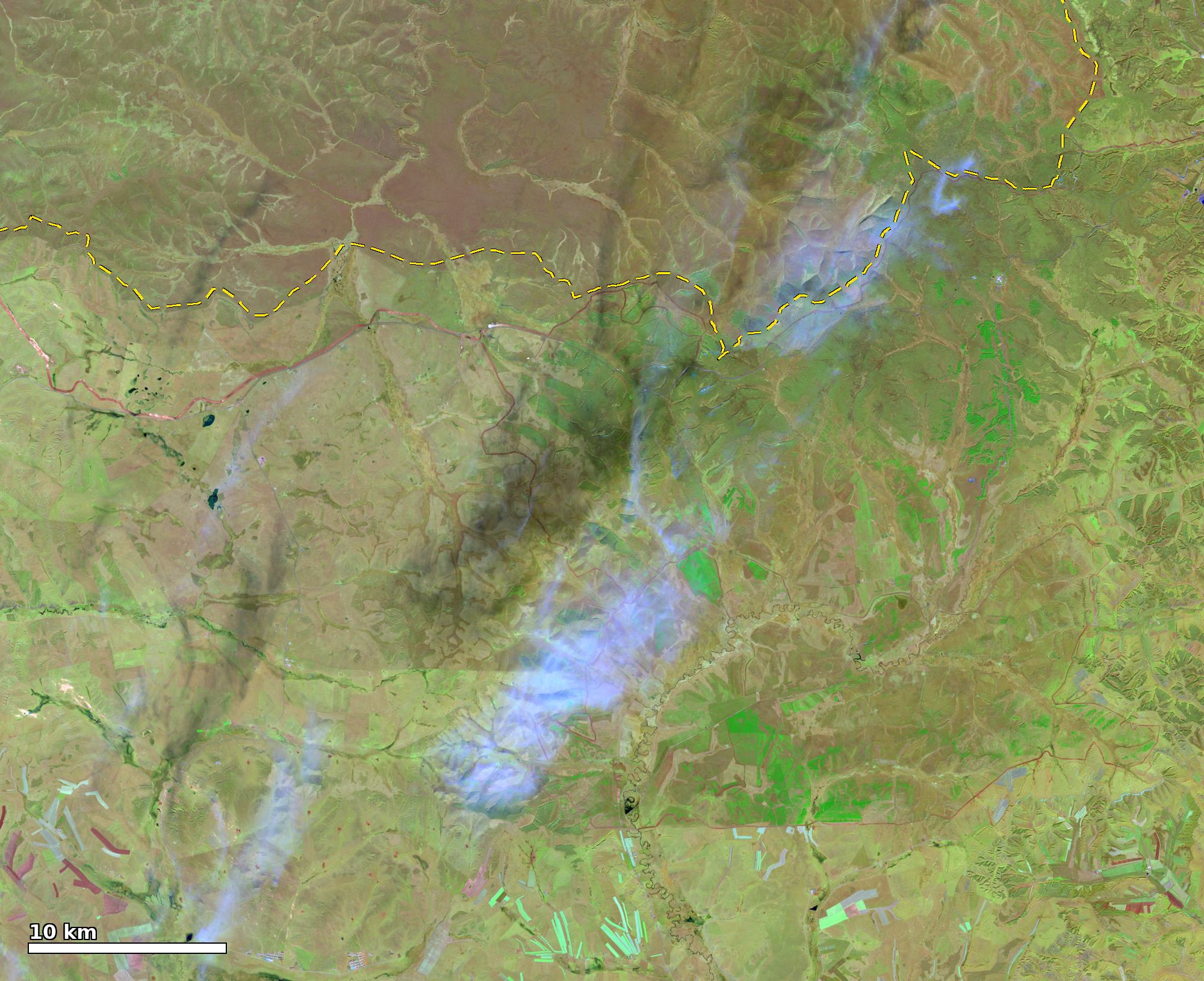 Before, 10-05 Sentinel-2C SWIR
After, 10-20 Sentinel-2B SWIR
Weather at the fire area: wind, humidity and the 10-12 cold front
Hourly weather at the fire area, 47.0°N, 119.4°E, 10-08 to 10-21. Before the magenta line (10-13 14:00 UTC+8): a model blend close to the observed weather; after it: the forecast.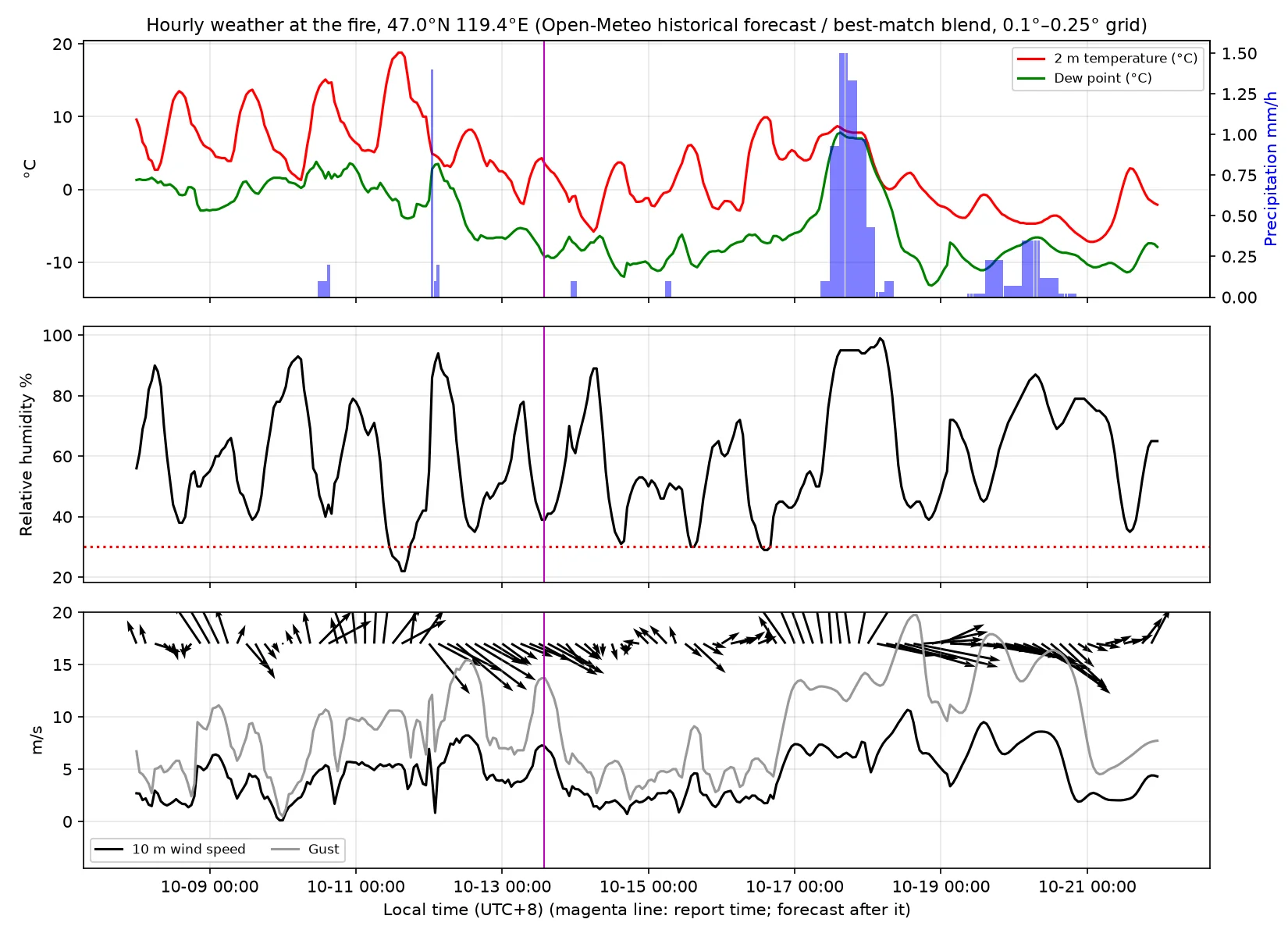
| Date | Temperature °C | Minimum relative humidity | Wind | Fire activity |
|---|---|---|---|---|
| 10-07 | 3 / 18 | 27% | Afternoon gusts 13 m/s | Day before ignition, dry |
| 10-08 | 3 / 14 | 38% | Weak north wind in the afternoon | Ignition at midday |
| 10-09 | 4 / 14 | 39% | Southeast wind 5–6 m/s at night, turning northwest in the afternoon | Fire line elongates to the northwest at night |
| 10-10 | 1 / 15 | 40% | Southwest wind 5 m/s in the afternoon, gusts 11 m/s | Main peak in the evening |
| 10-11 | 5 / 19 | 22% | South to southwest wind 5.5 m/s, gusts 10–11 m/s | Second peak; the eastern edge reaches the border |
| 10-12 | 0 / 8 | 35% | Cold front passes early in the morning; northwest wind 8 m/s, gusts 15 m/s, precipitation 1.7 mm | Weakens at night, resurges during the day, spreads southeast |
The 10-07 row comes from a different spliced series of archived forecasts. The series in the figure above starts on 10-08 and does not include 10-07. Temperatures in the two series may differ by a few tenths of a degree.
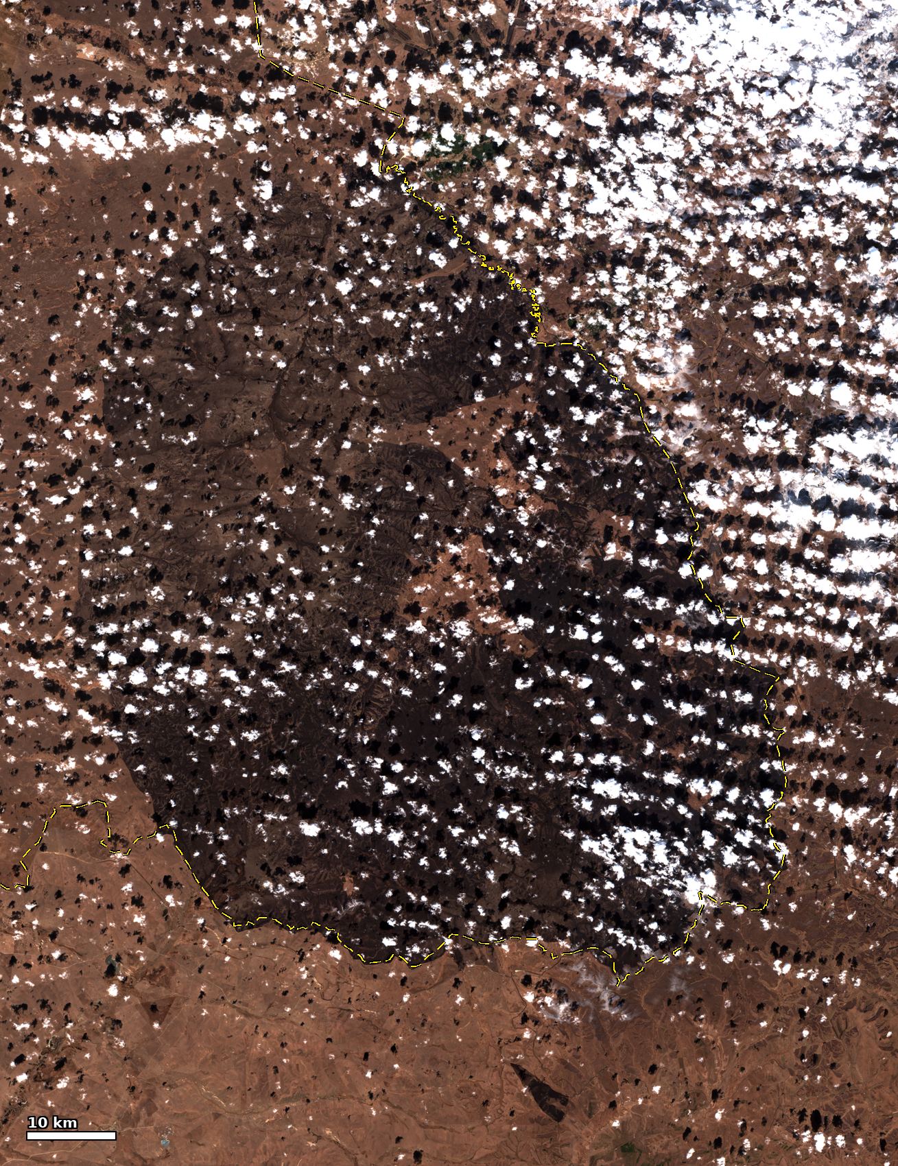
Since early October the fire area has had almost no precipitation, and surface soil moisture fell from 0.22 to 0.17 m³/m³. On the pre-fire image of 10-05, the whole grassland is already dry and yellow, forming a continuous layer of fine fuel.
On 10-10 and 10-11 the cold front had not yet passed, and in the afternoon the fire area had a southwest wind of 5 m/s with gusts of 10–11 m/s, coinciding with the two outbreaks. On the afternoon of 10-11, relative humidity fell to 22–25% and the temperature was 19 °C. After the cold front passed on 10-12, the wind turned northwest. The drop in temperature reduced fire intensity, and the wind direction pointed toward the border and Arxan.
The model forecasts initialized on 10-13 gave weak north to northwest winds for 10-14 and 10-15, and precipitation from 10-17. The main fire went out on the afternoon of 10-15, before the first forecast precipitation; the forecasts have not been checked item by item against observations.
Upper-air and surface patterns
ECMWF 10-13 00Z (top) and GFS 10-13 06Z (bottom) runs: 500 hPa geopotential height and the 250 hPa jet at 10-13 20:00 and 10-17 20:00 UTC+8.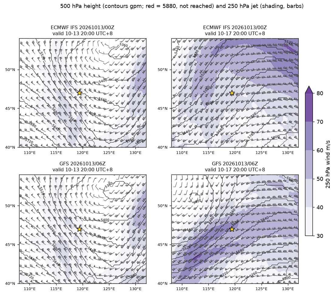
Sea-level pressure, 10 m wind and rain rate at the same two times. At 10-17 20:00 UTC+8 the ECMWF low centre is about 160 km northwest of the fire area (star), the GFS one about 490 km northwest.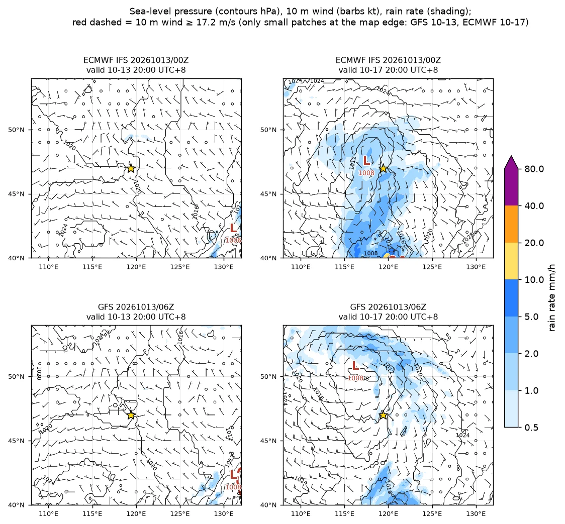
- 10-12: The cold front had moved east out of the fire area, and the fire area was in the northwesterly flow behind the front.
- The 250 hPa jet core was at 48°N, 125°E, at 75 m/s, and the fire area was beneath the jet entrance region.
- Downward transfer of momentum from aloft produced daytime surface gusts of 13–15 m/s.
- Sounding verification:
- At Hailar, from 20:00 on 10-11 to 08:00 on 10-12, the 850 hPa temperature fell from 8.7 °C to −1.7 °C, and the 500 hPa height fell by 104 gpm.
- At 20:00 on 10-13, the Hailar 500 hPa height was 5392 gpm, down 72 gpm in 12 hours (down 25 gpm in the previous 12 hours), with a temperature of −34.4 °C. At Nenjiang the height fell by 43 gpm. The low to the north was deepening and moving south.
- At the same time, the Xilinhot 500 hPa height was 5607 gpm, up 55 gpm, with a temperature of −22.6 °C, up 7.7 K, and northwest winds of 27–44 m/s from 500 to 250 hPa. The ridge to the southwest was strengthening, and the fire area lay in the tighter northwesterly flow between the two systems.
- Precipitable water was 4.2–7.8 mm, lowest at Xilinhot, and the 850 hPa dew point was −8.9 to −13.3 °C. The air was still very dry.
- Compared with the 4 sounding stations, the 6–12 hour ECMWF 00Z and GFS 06Z forecasts for 20:00 on 10-13 have a mean 500 hPa height bias of −14 gpm and a maximum of 21 gpm. The 500 hPa temperature biases are no more than 1.6 K, and the 250 hPa wind direction biases are no more than 10°.
Soundings at 10-13 20:00 UTC+8: Hailar, Xilinhot, Tongliao. Red line: temperature; green line: dew point; wind barbs in kt. The fourth panel gives each station’s precipitable water, freezing level, 850–500 hPa lapse rate and tropopause height.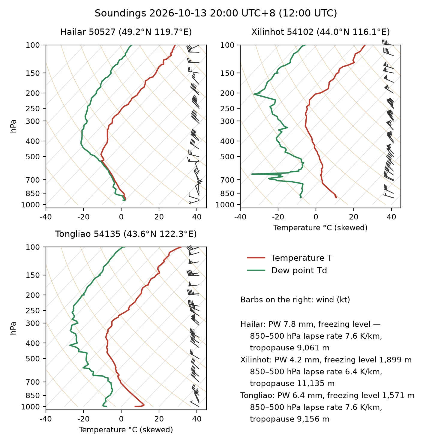
Satellite imagery: Sentinel-2, Landsat, daily MODIS/VIIRS and Himawari-9
High-resolution imagery before and after ignition
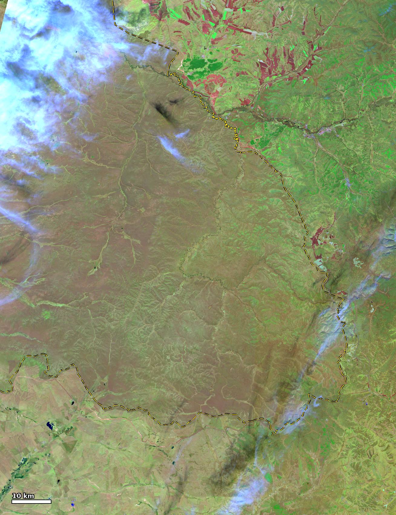 Before, 10-05 Sentinel-2C SWIR
After, 10-20 Sentinel-2B SWIR
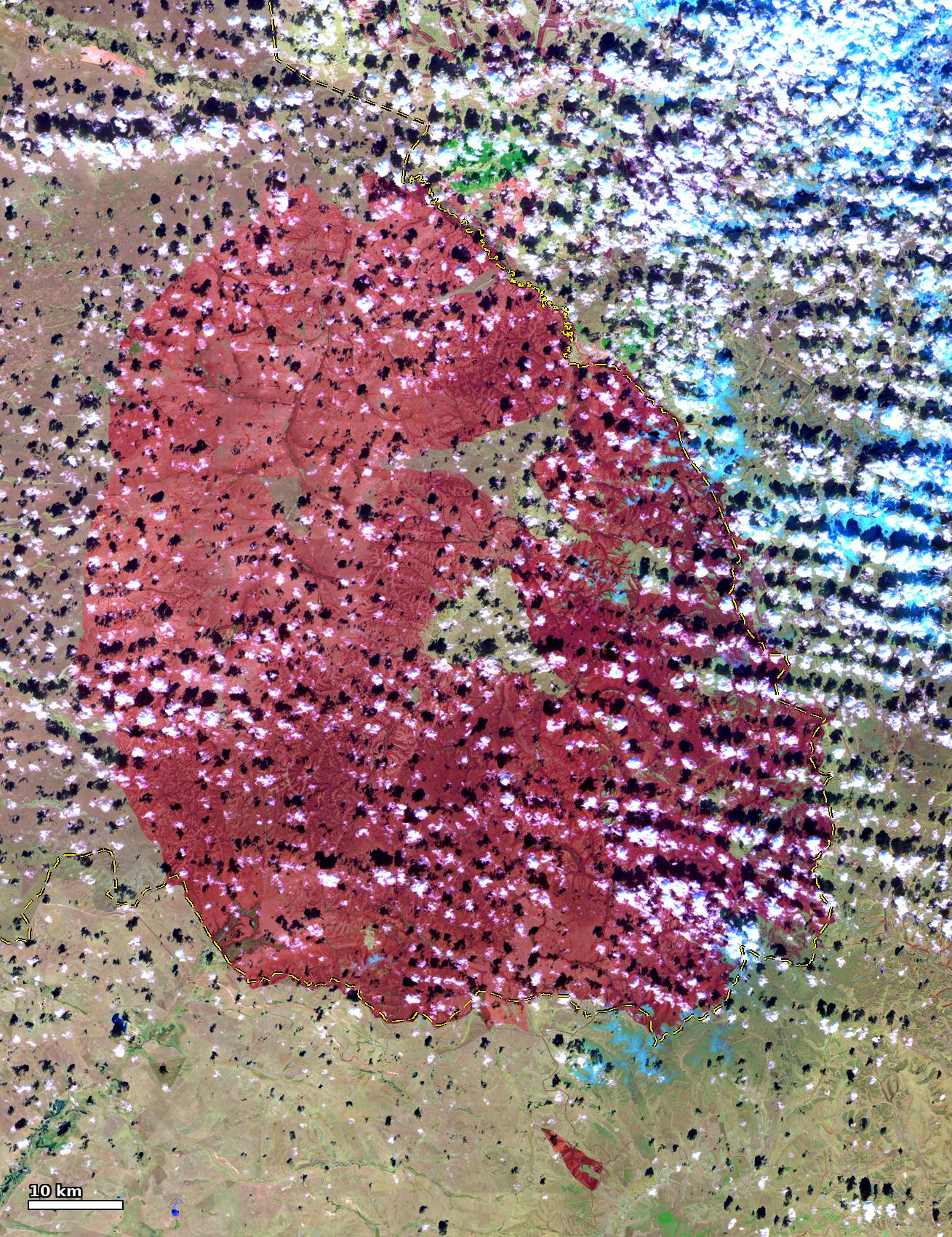
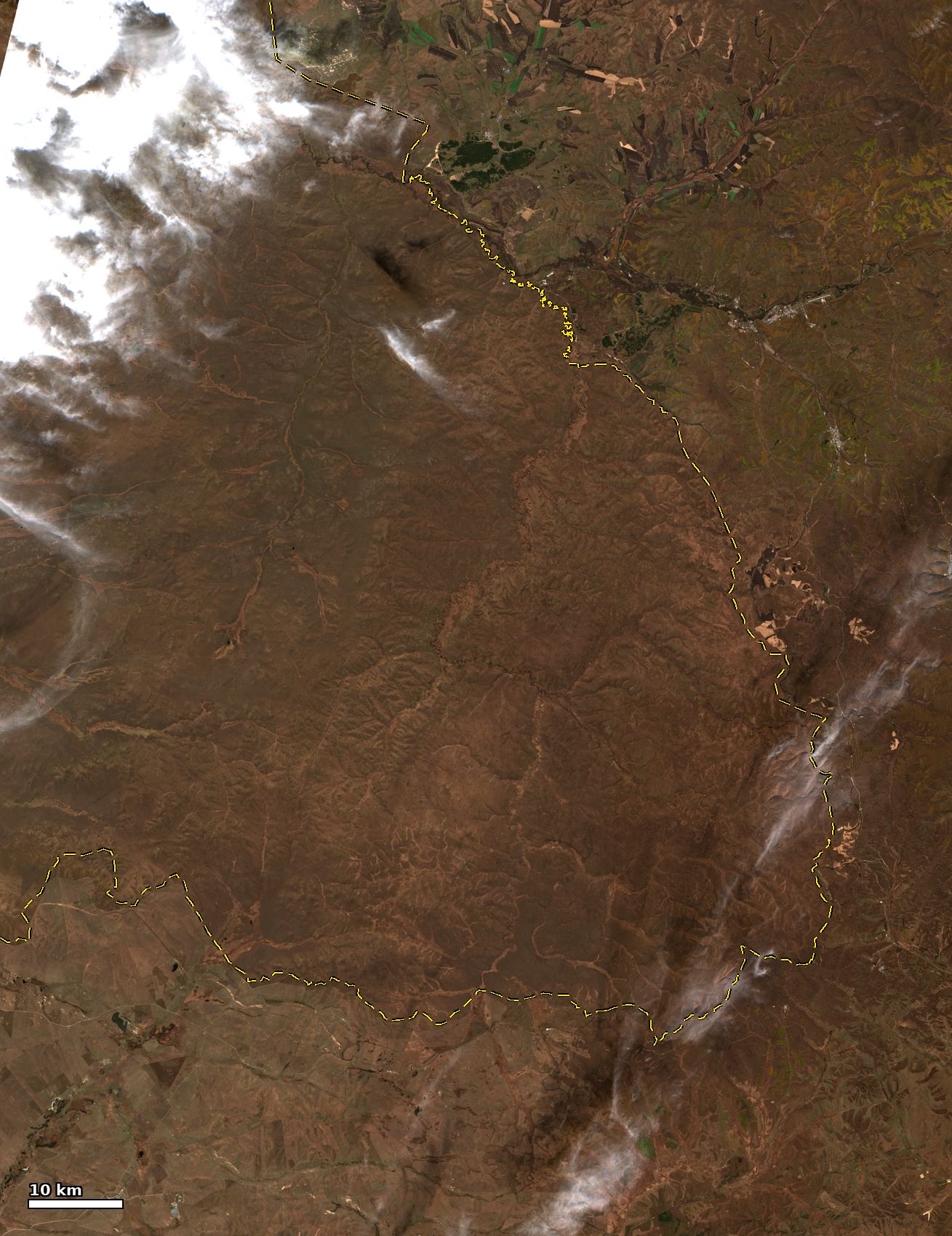 Before, 10-05 Sentinel-2C true colour
After, 10-20 Sentinel-2B true colour
Sentinel-2 comparison: 10-05 before the fire, 10-08 about 1 hour before ignition, 10-10 during the fire. Top row: true colour; bottom row: SWIR false colour (B12/B8A/B4). Yellow line: border (OSM); cyan dashed line: border (Natural Earth).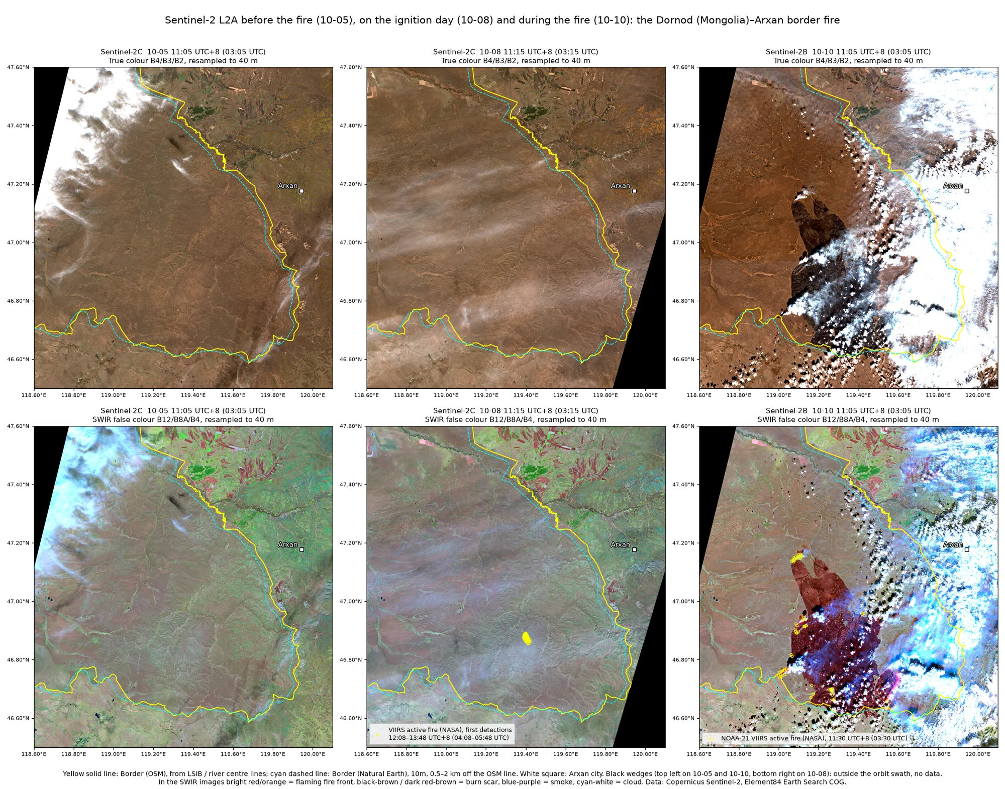
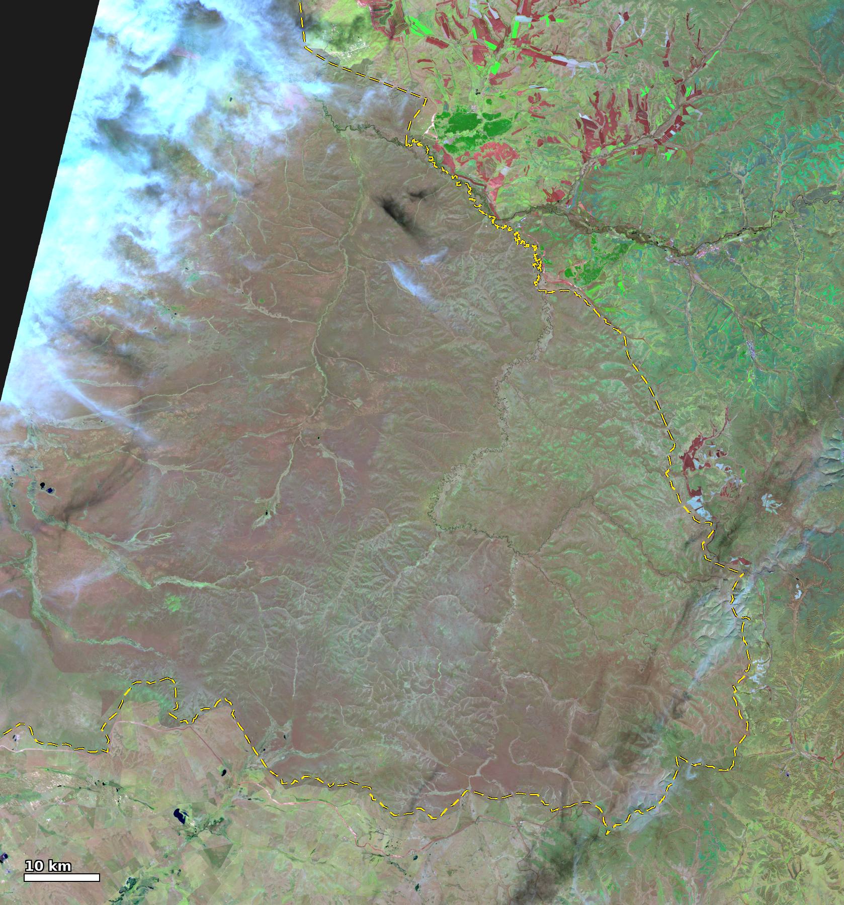 Before, 10-05 Sentinel-2C SWIR
During, 10-10 Sentinel-2B SWIR
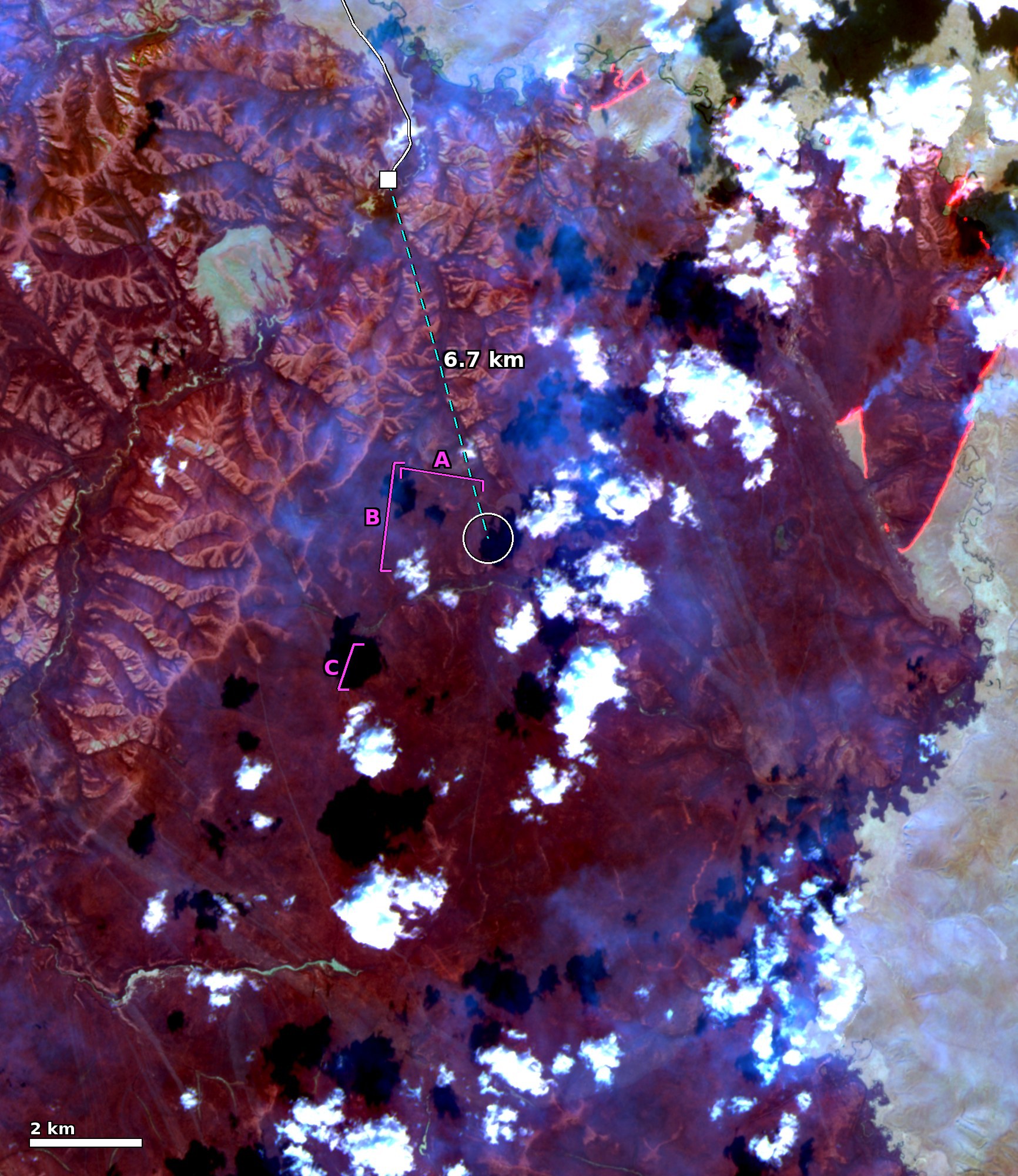
Ignition check: Landsat 9 at 10-08 10:45 UTC+8, SWIR false colour (30 m) and thermal-infrared surface temperature (fire area maximum 21 °C, no thermal anomaly), and Sentinel-2C at 11:15 UTC+8, SWIR false colour (10 m). Yellow circles: VIIRS active fire (NASA) detections of 10-08 12:08–13:48 UTC+8. Cyan star: ignition point (46.883°N, 119.395°E). White lines: OSM roads. White square: end of the OSM track nearest the ignition point (way 1571401319). Cyan dashed line: 6.7 km straight line from there to the ignition point. Magenta lines A/B/C: linear features of unknown nature on Sentinel-2 (hand-digitised, about ±50 m). Roads: OSM 2026-10-25 snapshot, © OpenStreetMap contributors (ODbL).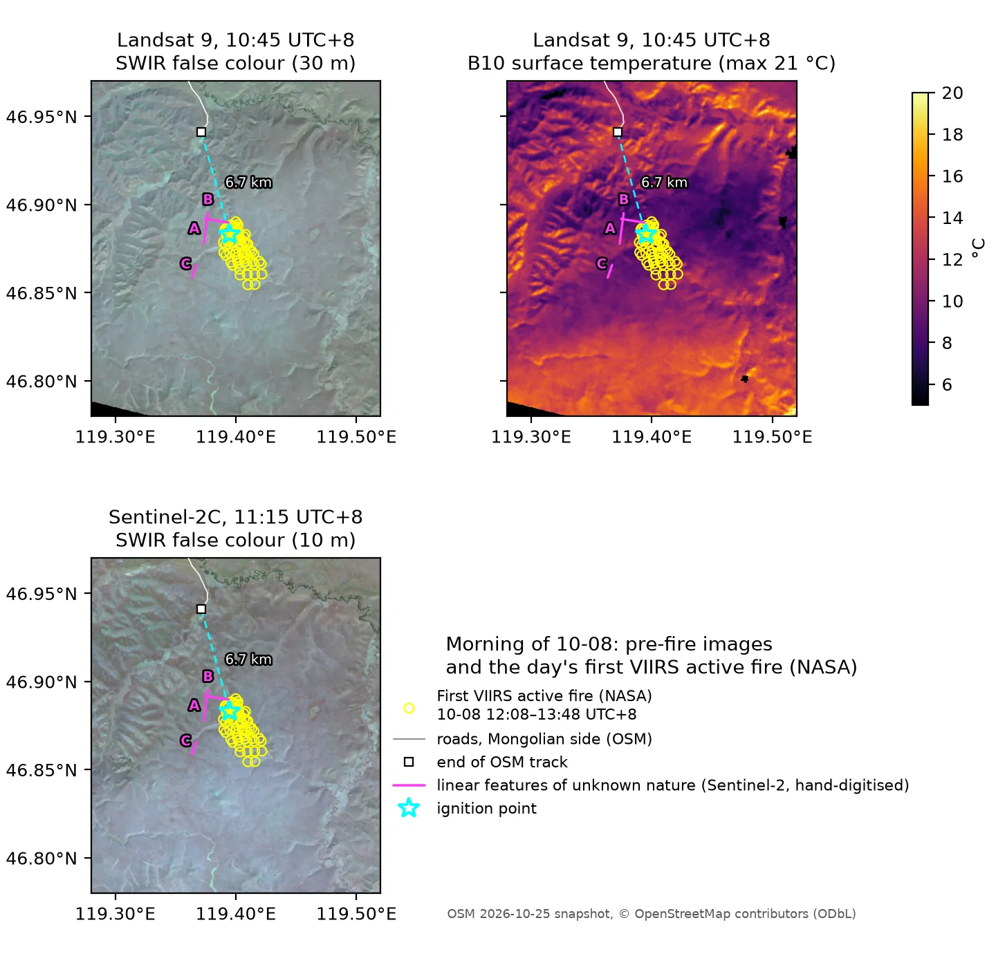
 10-08 11:15 Sentinel-2C SWIR, before ignition
10-10 11:05 Sentinel-2B SWIR, during the fire
Fire fronts at full 10 m resolution from Sentinel-2B, 10-10 11:05 UTC+8, with NOAA-21 VIIRS active fire (NASA) detections from 11:30 UTC+8.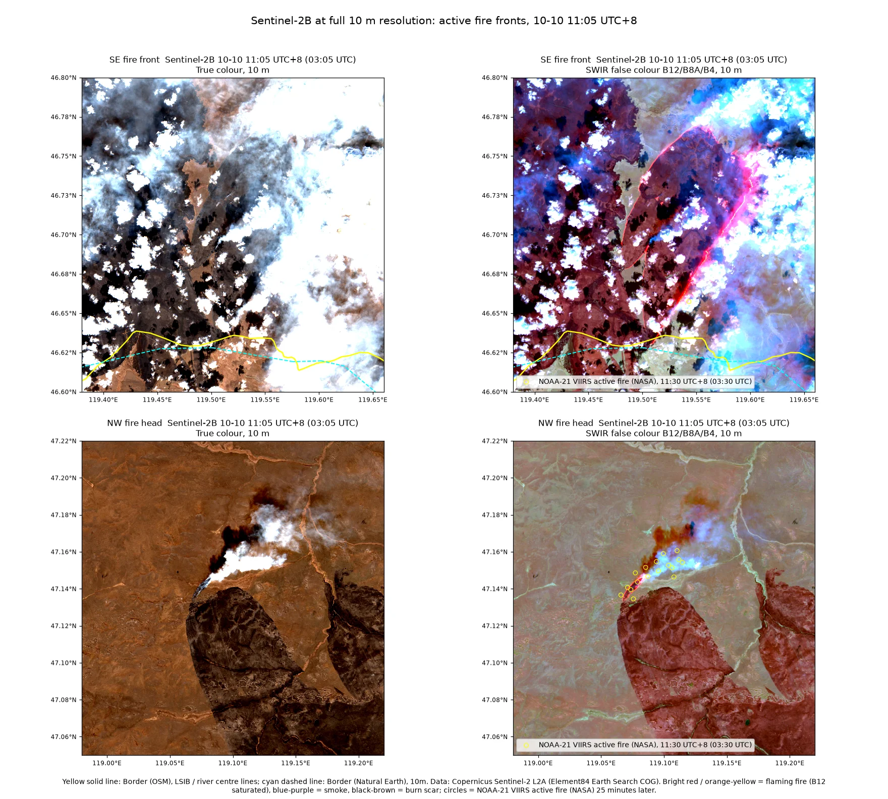
Daily imagery
Daily MODIS/VIIRS imagery, 10-07 to 10-09, 46–48°N, 118–121°E. Top row: true colour; bottom row: false colour (VIIRS M11-I2-I1 or MODIS 7-2-1). Yellow line: border (OSM); cyan dashed line: border (Natural Earth).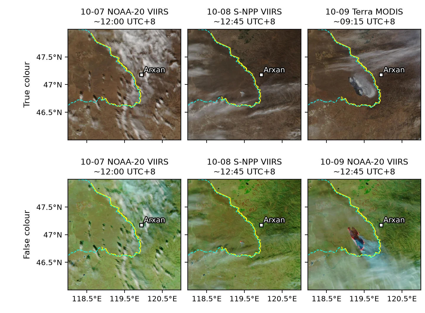
Daily imagery, 10-10 to 10-12, with the same extent and layout as above. In false colour, dark reddish brown is burn scar, bright red and orange are active fire, and cyan is smoke. The 10-12 column shows Terra only.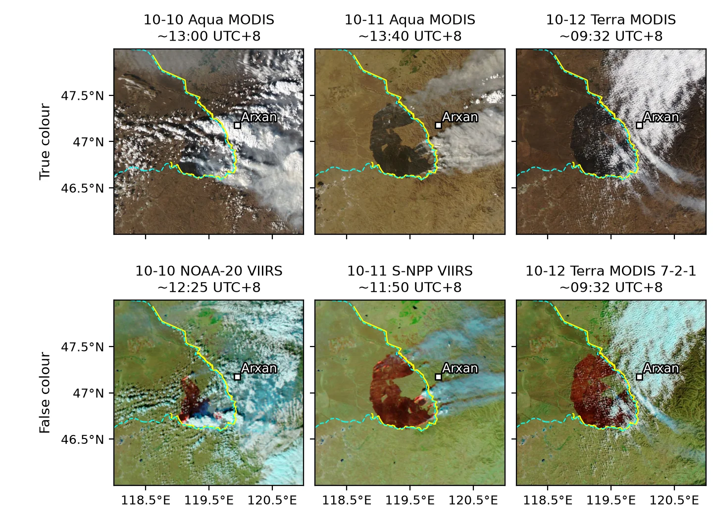
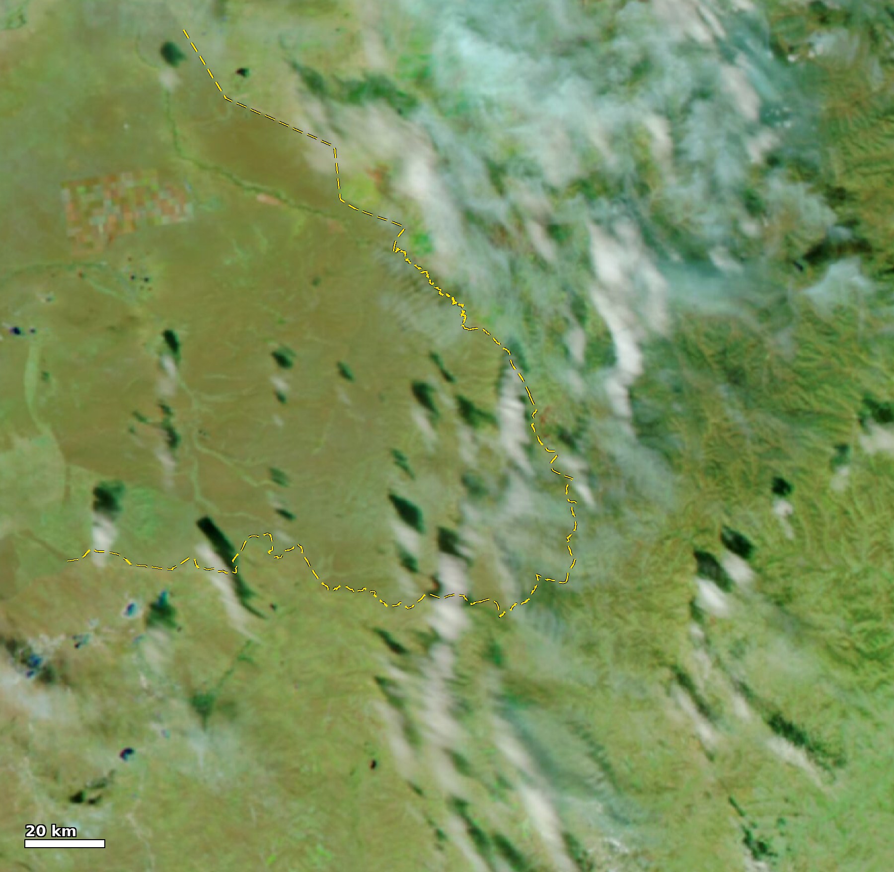 Before, 10-07 NOAA-20 VIIRS
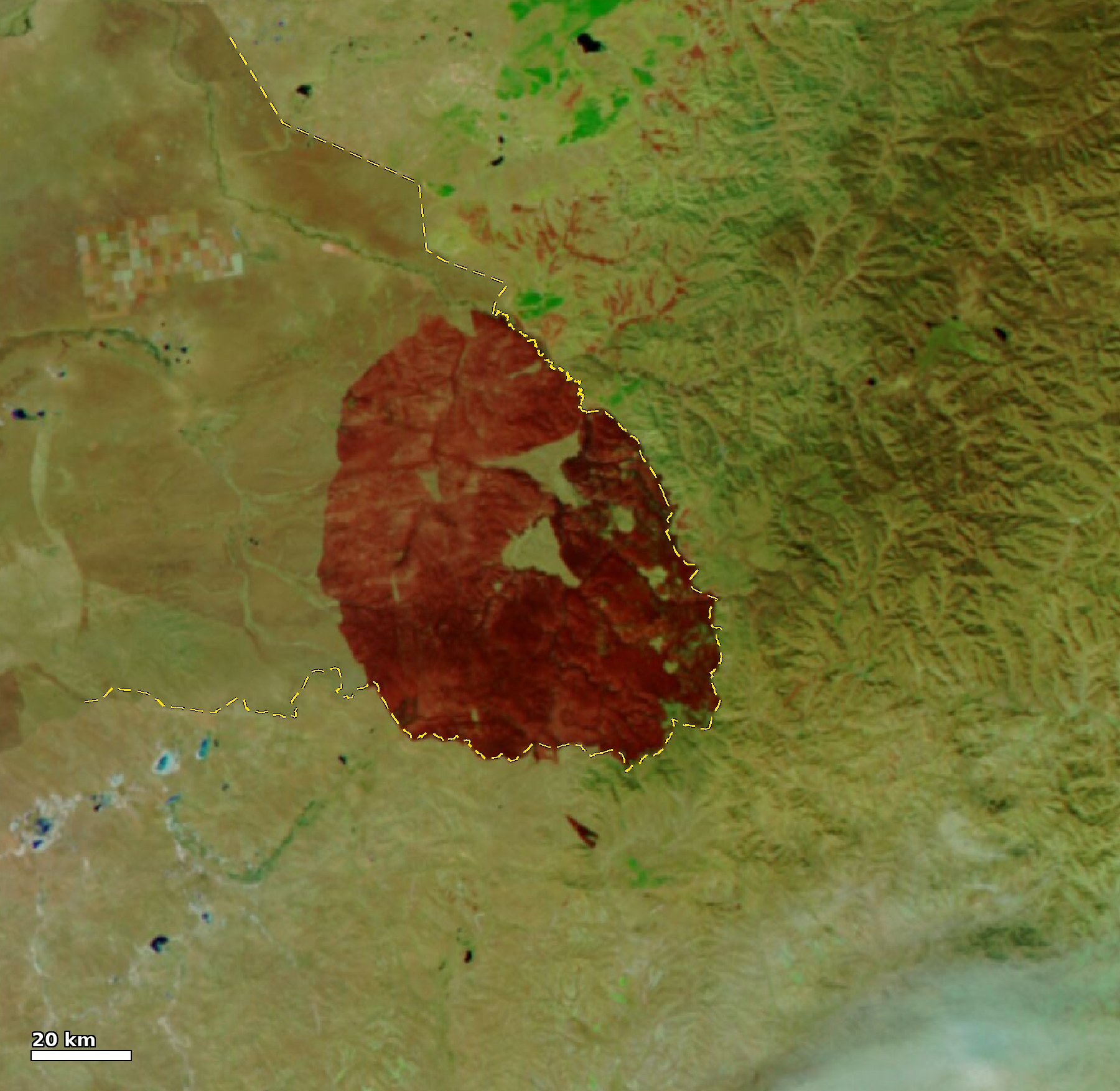
After, 10-16 NOAA-21 VIIRS
Himawari-9 fire channel
Himawari-9 B07 (3.9 µm) responds strongly to hot targets. It takes one frame every 10 minutes, which covers the intervals between polar-orbiting overpasses.
Himawari-9 B07 (3.9 µm, 2 km) brightness temperature at eight key times from 10-08 to 10-12. Cyan outlines: detected hotspots; white dashed line: China–Mongolia border (Natural Earth). The colour scale is clipped at 270–360 K; fire cores saturate at about 400 K.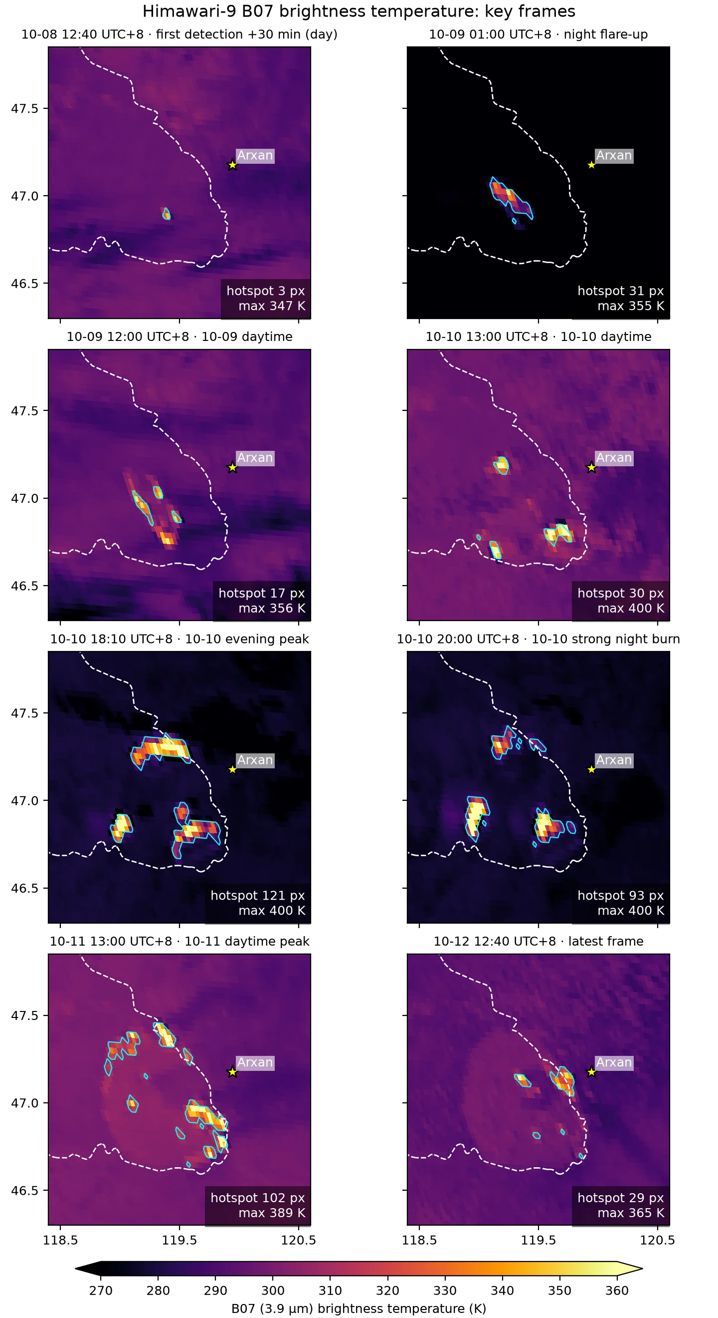
Time at which each 2 km pixel was first detected as a hotspot, with the 12-hour hotspot centroid track.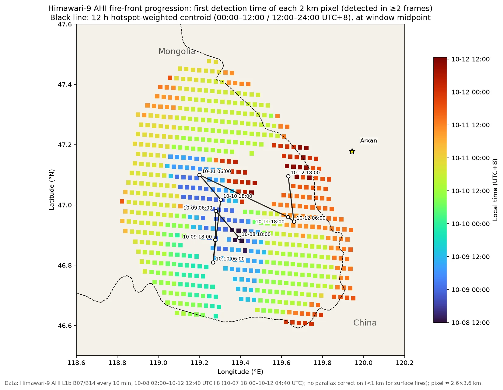
B07 brightness temperature at eight times from 10-12 12:40 to 19:40 UTC+8. Cyan outlines: detected hotspots; white dashed line: China–Mongolia border (OSM); yellow star: Arxan. The 400 K at 14:30 and 15:10 is B07 saturation. Before sunset, at 16:30, the solar zenith angle is about 82°; after that the night thresholds apply.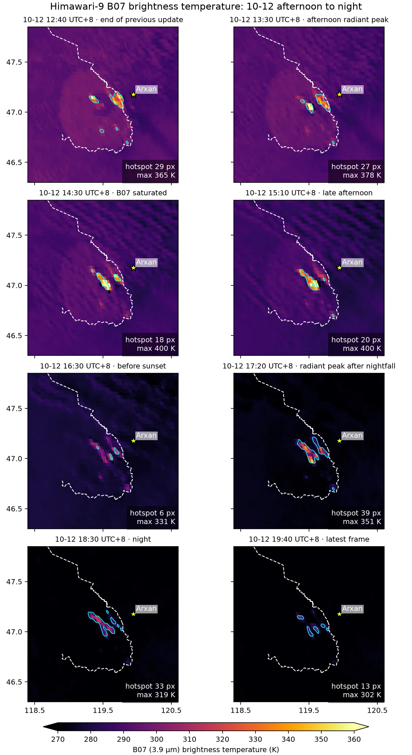
Hotspot pixels, 10-12 16:50–19:40 UTC+8. Square size ∝ number of detections, colour = time of the last detection; the circle marks 15 km around Arxan.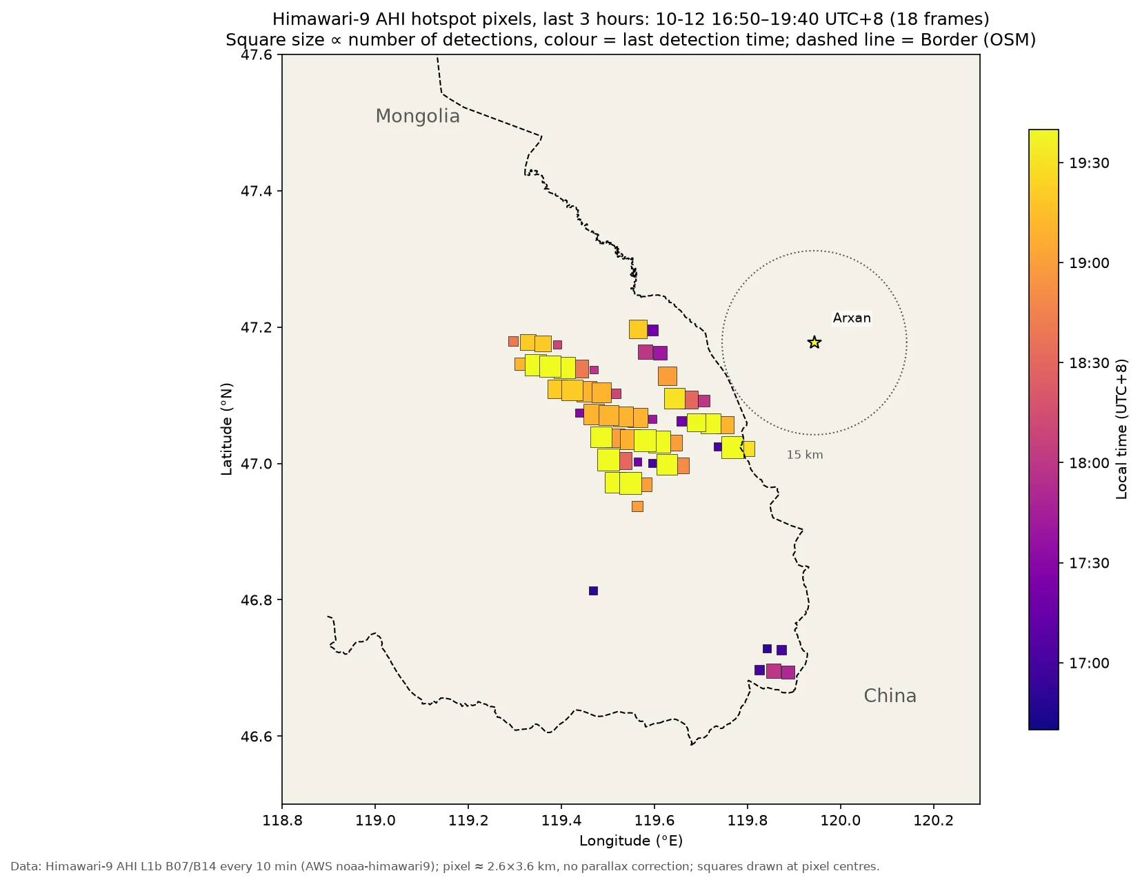
Himawari hotspot detection switches from daytime to nighttime thresholds when the solar zenith angle exceeds 85°, so the hotspot count jumps every day at 16:40–16:50. This jump comes from the detection method. The table below compares the same periods day by day:
| Period | 10-10 | 10-11 | 10-12 |
|---|---|---|---|
| Afternoon 12:00–16:00, mean hotspot pixels | 31.7 | 86.5 | 20.7 |
| Evening 17:00–19:40, mean hotspot pixels | 110 | 90 | 30 |
| Evening mean Σ(BT7−background) | 5053 K | 2453 K | 828 K |
Nights and the following mornings, compared with the same method:
| Period | Mean hotspot pixels | Mean Σ(BT7−background) |
|---|---|---|
| Night 17:00–05:00, 10-10/11 | 76.8 | 2945 K |
| Night 17:00–05:00, 10-11/12 | 41.4 | 1150 K |
| Night 17:00–05:00, 10-12/13 | 9.9 | 275 K |
| Morning 07:00–13:10, 10-12 | 10.9 | 381 K |
| Morning 07:00–13:10, 10-13 | 0.6 | 17 K |
On the night of 10-12/13 the count decreased from one period to the next: an average of 28.9 pixels from 17:00 to 20:00, 8.9 from 20:00 to 23:00, 1.4 from 23:00 to 02:00 and 0.4 from 02:00 to 05:00. In the second half of the night, the fraction of the fire core with BT14 < 265 K was 0.90–0.97, which may be low cloud, so the low values in the second half of the night may be underestimates. The 23:00 frame on 10-12 had 1 pixel on the Chinese side at 47.022°N, 119.799°E, 0.8 km from the line; an AHI pixel here is about 2.6×3.6 km, so the side of the border it is on cannot be resolved, and after 00:00 on 10-13 there were no hotspots within 5 km of the border. From 07:00 to 09:00 on 10-13 the fire area was mostly clear, and only 0–3 pixels were detected. During the day there were 9 hotspot pixels in total, at 46.97–47.20°N, 119.49–119.63°E, all on the Mongolian side, the nearest 5.2 km from the border. After 11:50 cumulus coverage was 0.42–0.87, and at 13:00 the fire core was fully cloud-covered.
From the afternoon of 10-13 the fire area was covered by cumulus. The afternoon and evening periods, compared day by day with the same method:
| Period | Date | Mean hotspot pixels | Mean Σ(BT7−background) | Frames with detections | Cloud fraction over fire core |
|---|---|---|---|---|---|
| Afternoon 13:20–16:40 | 10-10 | 28.8 | 1350 K | 21/21 | 0.15 |
| 10-11 | 68.6 | 2278 K | 21/21 | 0.00 | |
| 10-12 | 15.0 | 673 K | 20/21 | 0.01 | |
| 10-13 | 0.0 | 0 K | 0/21 | 1.00 | |
| Evening 17:00–22:00 | 10-10 | 104.4 | 4738 K | 31/31 | 0.00 |
| 10-11 | 75.7 | 1958 K | 31/31 | 0.14 | |
| 10-12 | 21.4 | 587 K | 31/31 | 0.09 | |
| 10-13 | 0.1 | 3 K | 2/31 | 1.00 |
After 13:20 on 10-13, cloud fraction over the fire core was above 0.9, and the low values on the afternoon and evening are caused mainly by cloud. From 13:20 to 22:00 there was only 1 pixel each at 18:40 and 19:50, both inside the residual burning zone in the middle of the fire area, 10.7–11.9 km from the border.
Smoke plume
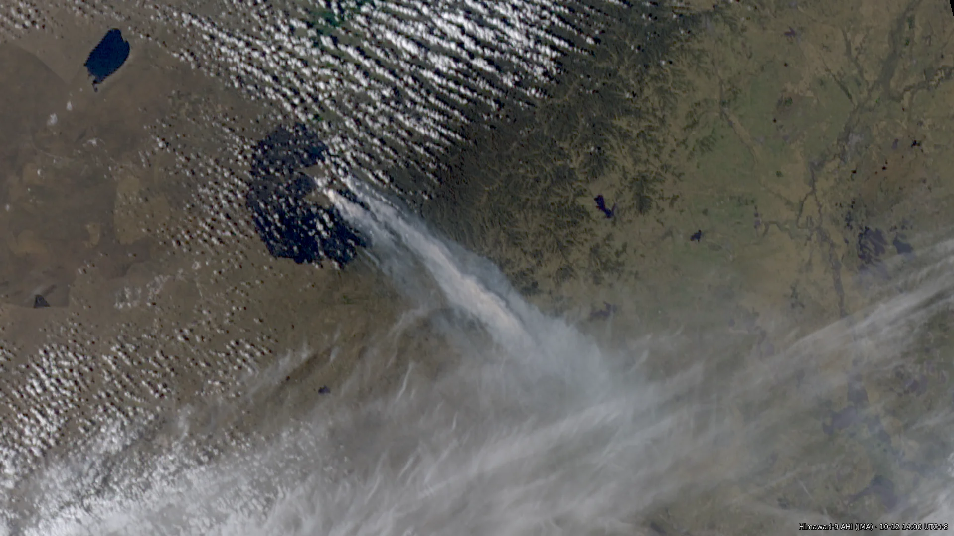
Himawari-9, 10-11 13:00 UTC+8: B03 0.5 km red band and true colour. The smoke plume heads east-northeast and passes south of Arxan.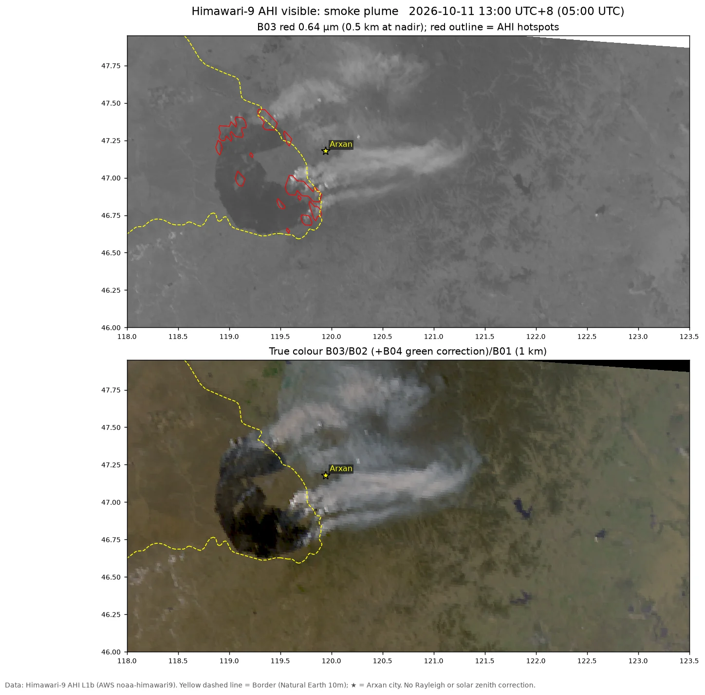
Himawari-9, 10-12 14:00 UTC+8. The smoke plume has turned southeast, crosses the border and is at least 150–180 km long. Red outlines: hotspots.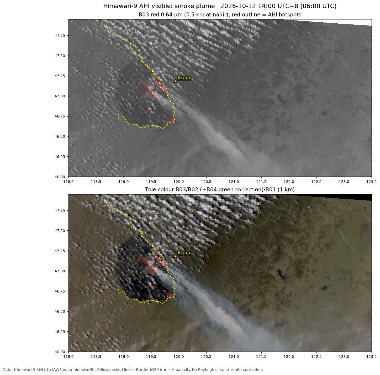
Wide-area true colour from the five satellite overpasses on 10-12, 44–50°N, 114–124°E, in overpass order. Yellow line: border (OSM); cyan dashed line: border (Natural Earth).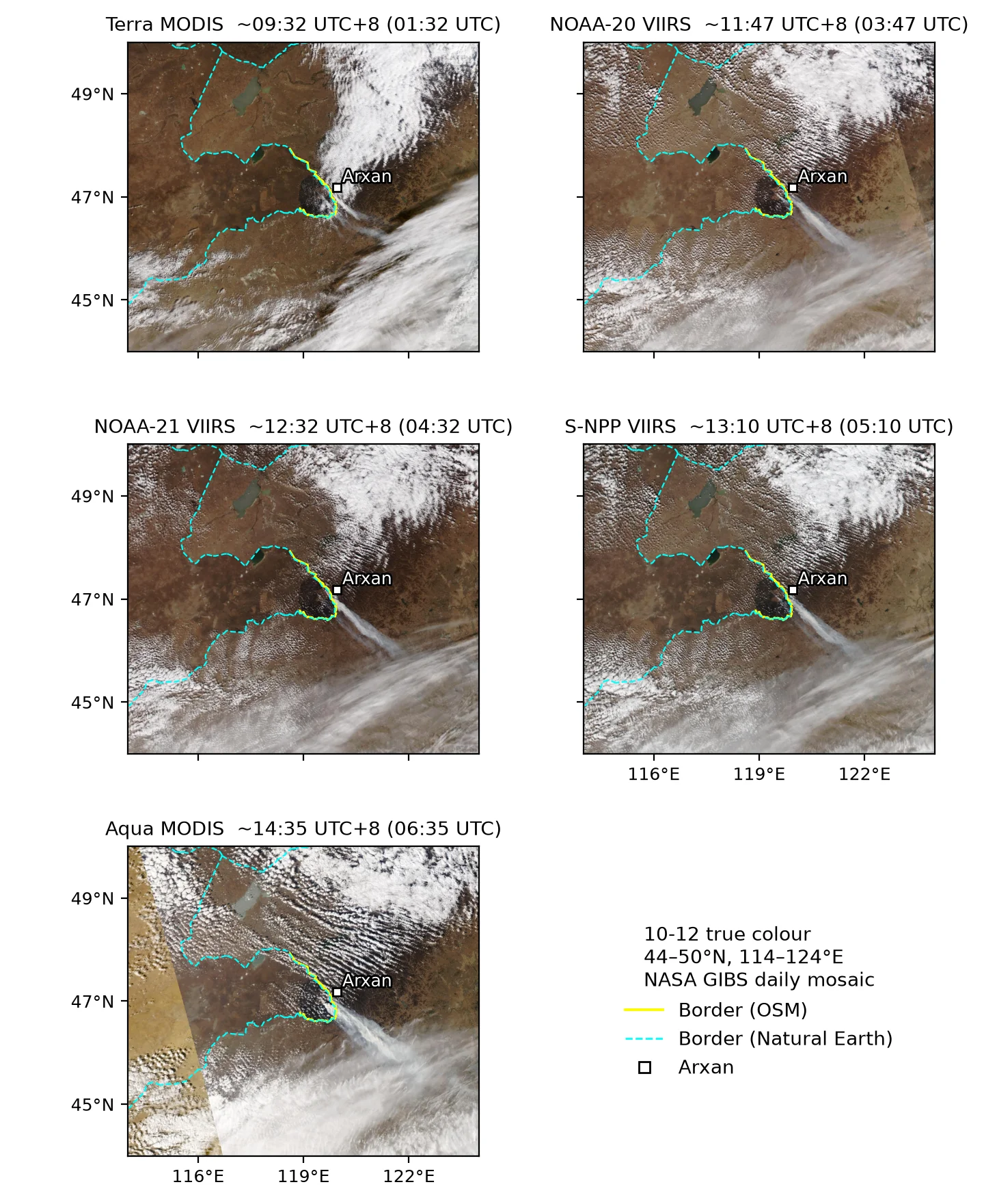
Himawari-9, 10-13 09:00 UTC+8. Top: B03 0.5 km red band; bottom: 1 km true colour. A narrow smoke band crosses the border toward the south-southeast. Red outlines: hotspots.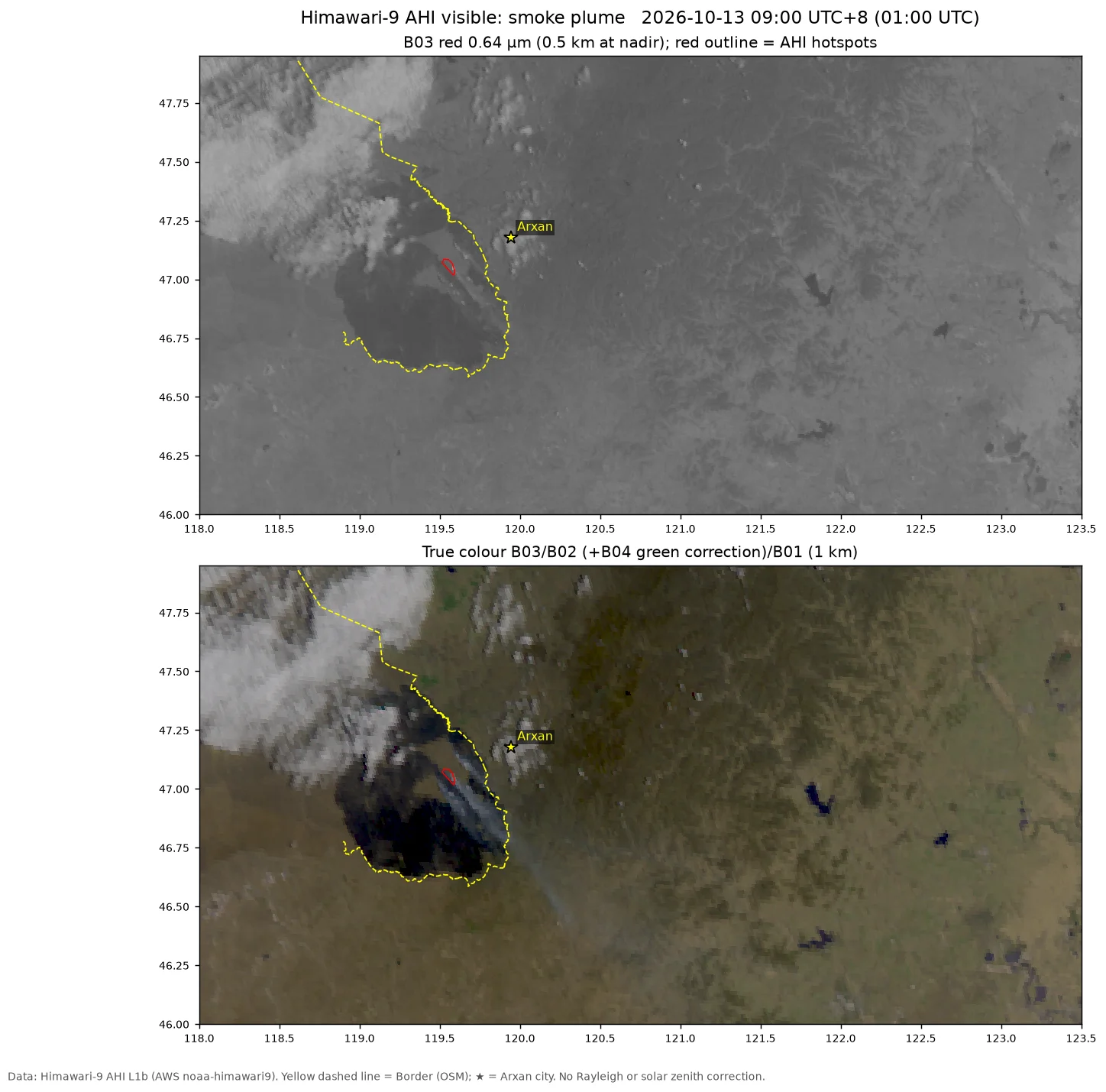
Himawari-9 visible, 10-13 14:00 UTC+8: the fire area, the border and Arxan are all under cumulus.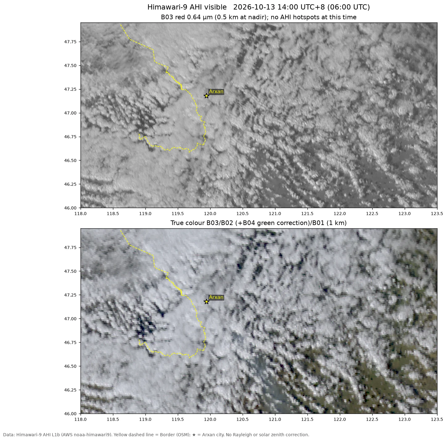
| Date | Plume direction | Area affected |
|---|---|---|
| 10-09 | Southeast to east | Toward Arxan |
| 10-10 | East to northeast, spreading toward 48–49°N | Northern Hinggan League, southern Hulunbuir |
| 10-11 | Two branches: the main branch toward east-northeast (about 75–80°), about 130 km long, reaching 121.5°E; a weaker branch toward the northeast, extending toward 120.5°E, 47.8°N | The main branch passes south of Arxan |
| 10-12 | One dense plume toward the southeast (about 140°), about 200 km long, reaching 46.0°N, 121.5–122°E | Passes 25–35 km south of Arxan, toward Horqin Right Front Banner and Ulanhot |
| 10-13 | At 09:00, a narrow smoke band at a bearing of 140–145°, from about 47.07°N, 119.55°E to 46.45°N, 120.25°E, about 90 km long and 5–10 km wide | Passes 35–40 km southwest of Arxan; downwind is western Horqin Right Front Banner |
The turn of the plume matches the change in the wind field: after the cold front passed early on 10-12, the wind turned from southwest to northwest. After 11:00 on 10-13 cumulus developed widely. At 12:00 a band of smoke haze 20–25 km wide was still visible between the clouds, with its northern end about 20 km south of Arxan, and by 13:00 only scattered smoke haze remained. After 14:00 the fire area, the border and Arxan were all under cumulus and mid-level cloud, and no smoke plume could be distinguished.
Burned area: about 4,900 km², compared with the NMC estimate of 5,050 km²
Burned area extracted automatically from the imagery of the five satellite overpasses on 10-12 (magenta outline); each panel title gives the burned area and the part outside the border line (OSM). Cyan in the southeast: smoke plume; yellow line: border (OSM); cyan dashed line: border (Natural Earth).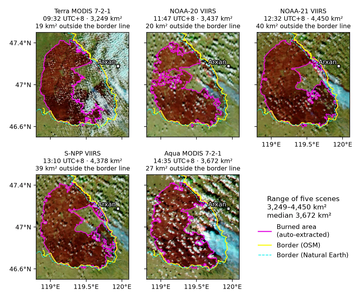
| Time | Method | Area |
|---|---|---|
| 10-10 11:05 | Sentinel-2 dNBR > 0.27 (20 m), counting only regions connected to fire pixels | 865 km² (lower bound) |
| 10-10 11:05 | As above, plus the outer extent after morphological closing and hole filling (including areas under cloud and smoke) | 1,150 km² |
| 10-11 to morning of 10-12 | Threshold extraction from MODIS/VIIRS false color, 4 scenes | 3,340–3,710 km² |
| Midday 10-12 | Same method, using the two clearest scenes, from NOAA-21 and S-NPP (1.6% apart) | About 4,400 km² (3,800–5,000) |
| 10-13 08:35 | One Terra scene, green-channel threshold relaxed from < 75 to < 110 | Largest connected region 4,193 km², all regions 4,273 km² |
| Midday 10-14 | Same method, using the two fully clear S-NPP and NOAA-20 scenes of 10-14, minus the still-unburned part of the unburned island in the middle | 4,905–4,948 km²; best estimate about 4,900 km² (4,750–5,000) |
| Midday 10-16 | Same method, using the two fully clear NOAA-21 and NOAA-20 scenes of 10-16, without hole filling | 4,898–4,915 km²; still about 4,900 km² (4,750–5,000) |
| Morning 10-20 | Sentinel-2 20 m dNBR (10-05/08→10-20, threshold 0.20), same area rules, minus the unburned island | About 4,850 km²; thresholds 0.10–0.27 give 4,540–5,015 km²; still about 4,900 km² |
Burned area extracted automatically from the two clearest VIIRS scenes of 10-12 and from Terra at 10-13 08:35 UTC+8. Magenta: main patch; cyan: all patches of 5 km² or more; cyan numbers: areas of the detached patches (km²). White circles: hotspot positions reported by the China Meteorological Administration from FY-4C; yellow line: border (OSM). Panel 3 uses the original threshold; panel 4 relaxes the green-channel threshold.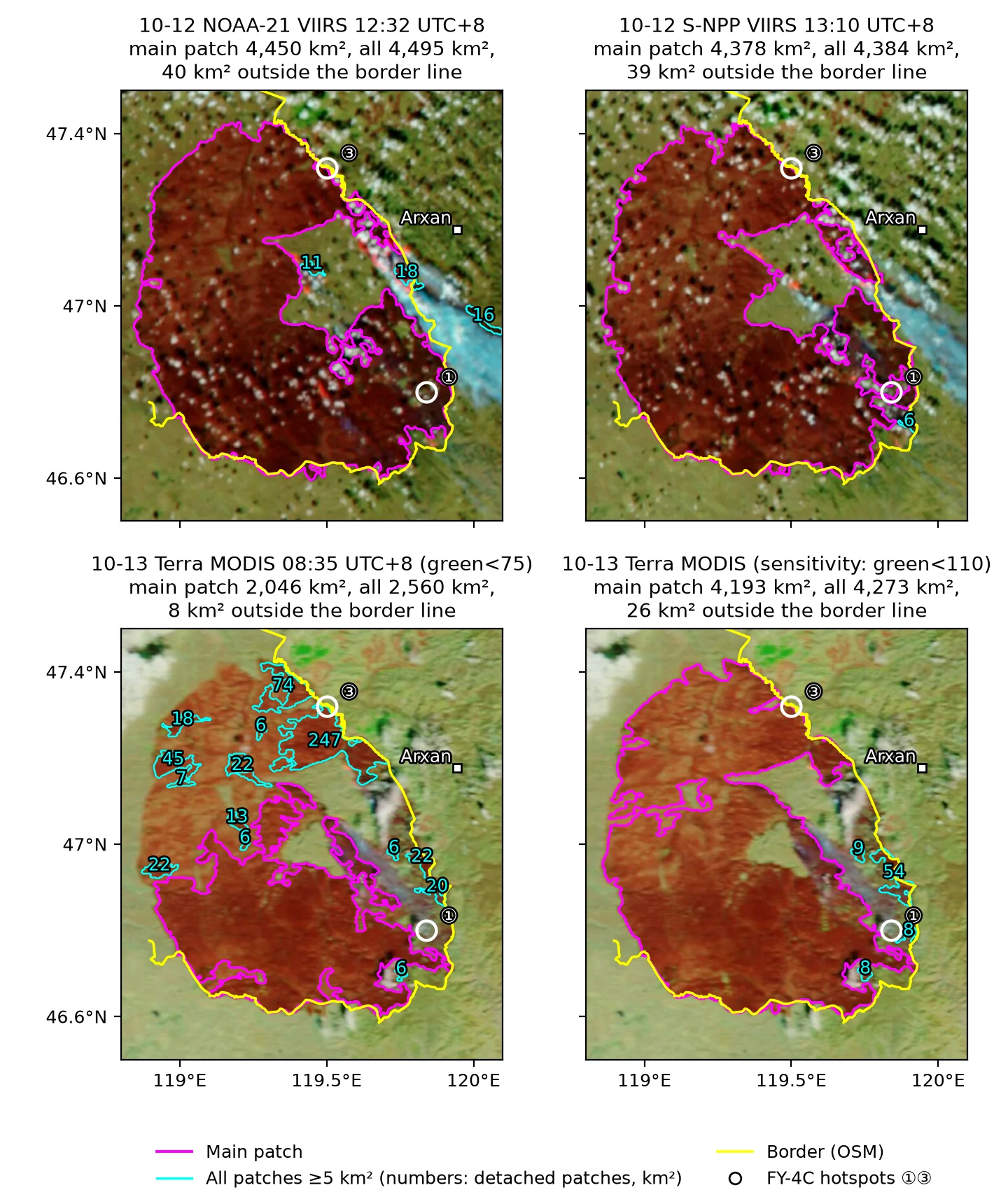
In the 10-13 NOAA-20 VIIRS scene, most of the fire area is covered by cumulus. The same method extracts only 47–219 km², broken up by cloud, which cannot be used to update the area; the clear part shows no new cross-border burn scar. On 10-13, therefore, only the Terra scene is usable. It lies at the eastern edge of the swath, where pixels are large and the image is bright. The original threshold gives only 2,046 km², split into a dozen or more pieces, so the green-channel threshold was relaxed with the other conditions unchanged. The result agrees within error with the 4,380–4,450 km² from the two 10-12 VIIRS scenes. About 110 km² inside the unburned island on the 10-13 Terra scene was not counted at the time; see below. The area is measured to the outer edge of the burn scar. It includes small unburned patches inside the fire area and excludes separate small fires outside it.
Recalculation on 10-14 and 10-16
At midday on 10-14 the S-NPP and NOAA-20 scenes were fully clear over the fire area, and the area was recalculated with the same threshold. Recalculating the 10-12 and 10-13 scenes reproduces every earlier result; for example, 10-12 NOAA-21 is still 4,450 km².
Burn scar change: the 10-12 NOAA-21 reference burn scar (white line) and the new burn scar on 10-14 S-NPP and 10-15 NOAA-21 (magenta, holes not filled), with the daytime FIRMS fire detections of the same day. Yellow line: border (OSM). In the 10-15 scene the southern half of the fire area is under cloud.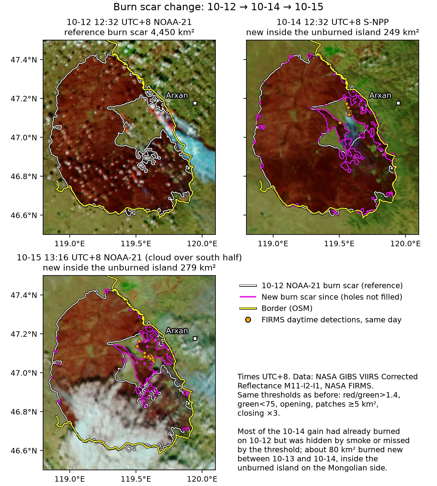
On 10-12 the unburned island in the middle of the fire area was open to the east, so it was not filled in and counted. By 10-14 it was surrounded by burn scar on all sides. The original hole-filling step would therefore also count the 357–386 km² inside it that was still unburned, which gives largest connected regions of 5,291 km² and 5,304 km² for the two scenes. Subtracting this part gives 4,905 km² and 4,948 km².
Relative to the 4,450 km² of 10-12 NOAA-21, the roughly 500 km² added consists of three parts (the two numbers are for S-NPP and NOAA-20):
| Part | Area (km²) | Timing |
|---|---|---|
| Inside the unburned island in the middle, 46.95–47.25°N, 119.25–119.70°E | 249 / 278 | Taking NOAA-20 as an example, about 180 km² of the 278 km² was already burn scar on Terra at 08:35 on 10-13; about 80 km² burned between the morning of 10-13 and midday on 10-14, mainly in the eastern half of the unburned island, 119.5–119.7°E |
| Eastern front, 46.85–47.13°N, 119.70–119.93°E | 125 / 131 | About 90 km² of the 131 km² was already burn scar on 10-12 S-NPP; in the 10-12 NOAA-21 scene this area was hidden by smoke |
| Narrow band along the edge of the 10-12 burn scar, ≤ 1.5 km from the edge | 127 / 128 | 1–4 pixels wide; may come from differences in viewing geometry and brightness between the two scenes, and is not necessarily new burning |
Most of the increase had already burned on 10-12 but was hidden by smoke in the 10-12 NOAA-21 scene or missed by the threshold; the comparison with the NMC estimate below gives details. The roughly 190 km² that newly burned between the afternoon of 10-12 and midday on 10-14 is all inside the unburned island on the Mongolian side. About 110 km² of it already appears on Terra at 08:35 on 10-13 and in none of the five 10-12 scenes, and about 80 km² burned between the morning of 10-13 and midday on 10-14. Excluding the narrow band along the edge, the total is about 4,780 km². The best estimate is therefore revised to about 4,900 km², with a range of 4,750–5,000 km²; the lower end excludes the narrow band along the edge.
In the NOAA-21 scene at 13:16 on 10-15, the unburned island is 99% clear, and the burn scar inside it is 279 km², level with the 278 km² of 10-14 NOAA-20. Before midday on 10-15, therefore, there was no resolvable growth inside the unburned island. This scene has cloud over the southern half of the fire area (south of about 46.95°N) and cannot be used for the total area. In the 10-14 Terra and Aqua scenes, as in the 10-13 Terra scene, the burn scar appears too bright and the original threshold fails, so areas from 10-14 onward use VIIRS only.
The fire area was fully clear during the three VIIRS overpasses on 10-16, and the area was recalculated with the same threshold. The largest connected regions (without hole filling) in the NOAA-21 and NOAA-20 scenes are 4,915 km² and 4,898 km². The western half of the S-NPP scene is bright and its burn scar is broken up, giving only 4,195 km²; with the green-channel threshold relaxed to < 110 it is 4,743 km². The estimate remains about 4,900 km² (4,750–5,000 km²), with no growth after 10-14. The new burn scar south of the main fire is not included.
Method and errors
- dNBR: NBR = (B8A − B12)/(B8A + B12), and dNBR is the pre-fire NBR minus the post-fire NBR. The pre-fire image is from 10-05, with cloudy areas filled from 10-07.
- Reasons dNBR is biased low:
- dNBR is biased low under dense smoke.
- The Sentinel-2 scene classification often misclassifies black burned ground as “cloud shadow”, so only the cloud classes were masked.
- Error of moderate-resolution imagery: 250–375 m imagery is affected by pixel size, cloud shadow and smoke, with an error of about ±10–15%.
- The roughly 800 km² added from 10-11 to 10-12: Part of it is area that was hidden by smoke on 10-11 and became visible on 10-12. The rest is actual spread of the fire on the east side of the fire area and into unburned patches in the middle.
- The 10-13 Terra result: With the relaxed threshold it agrees with VIIRS. It is used only as supporting evidence that there was no growth and does not replace the 10-12 estimate.
Comparison with the NMC estimate
The Global Severe Weather Monitoring and Forecast Bulletin (《全球灾害性天气监测预报快讯》)13 issued by the NMC and other agencies at 19:00 on 10-12 states that “based on satellite remote sensing estimates, the burned area is about 5,050 square kilometers” (通过卫星遥感估算,过火区面积约 5050 平方公里). The bulletin does not give the satellite, time or method behind this estimate; the latest image in the same bulletin is from FY-4C at 14:40. The figure of 5,050 km² is about 15% above this post’s 10-12 estimate of 4,400 km², about 3% above the recalculated 10-14 figure of about 4,900 km², and about 1% above the upper end of the range, 5,000 km². The two agree within the error of the two satellites and methods.
Of the gap of about 600 km² between 4,450 km² and 5,050 km², about half comes from the 250–300 km² missed by the single-scene method on 10-12; the rest may come from pixel size or the area definition, see below.
There are five GIBS scenes on 10-12, all earlier than 14:40. The earlier approach extracted each scene separately and used only the clearest scene, from NOAA-21, which gave 4,450 km². Each scene misses different parts of the edge. The part of each scene that extends beyond NOAA-21 is compared with the 10-14 NOAA-20 burn scar:
| 10-12 scene | Beyond NOAA-21 (km²) | Of which inside the 10-14 burn scar (km²) |
|---|---|---|
| Terra 09:32 | 56 | 49 |
| NOAA-20 11:47 | 168 | 161 |
| NOAA-21 12:32 | 45 | 21 |
| S-NPP 13:10 | 245 | 226 |
| Aqua 14:35 | 159 | 102 |
The NOAA-21 row is the difference between all connected regions and the largest connected region. In the NOAA-21 scene the eastern front is hidden by smoke, while S-NPP at 13:10 shows this section. The union of the NOAA-21 and S-NPP scenes is 4,724 km², of which 4,686 km² is inside the 10-14 burn scar. In the union of all five scenes, the part confirmed by 10-14 is 4,743 km²; another 98 km² lies outside the 10-14 burn scar and is probably false patches caused by cloud or smoke. Using only the 10-12 data, combining several scenes therefore gives an estimate of about 4,700 km².
A gap of about 350 km² remains between 4,700 km² and 5,050 km². There are two possible sources. Their shares cannot be determined, because the NMC has not published its method:
- Later burning: Between the afternoon of 10-12 and midday on 10-14, about 190 km² more burned inside the unburned island. About 110 km² of this already appears on Terra at 08:35 on 10-13, and about 80 km² burned between the morning of 10-13 and midday on 10-14. This burning is later than the FY-4C image at 14:40, so the 5,050 km² should not include it.
- Pixel size or burn scar threshold: An FY-4C pixel at 47°N is about 2.5–3 km, which expands the burn scar edge outward. Expanding the 10-12 VIIRS burn scar boundary outward by 0.5 km adds 285–326 km², and by 1 km adds 496–570 km². Larger pixels and a looser threshold both expand the boundary.
Two other items:
- Detached small patches: Keeping all connected regions of 5 km² or more adds only 6–45 km² (0.1–1%) to the two 10-12 VIIRS scenes, and 15.5 km² of that is false patches under smoke. The gap does not come from this item.
- Area definition: The table below gives the two 10-12 VIIRS scenes recalculated with different definitions.
| Definition | NOAA-21 (km²) | S-NPP (km²) |
|---|---|---|
| Burned pixels only, excluding unburned patches inside the fire area | 4,117 | 3,935 |
| Definition used in this post: fill unburned patches fully enclosed by burn scar | 4,450 | 4,378 |
| Outer outline, including indentations into the fire area up to 1 km wide | 4,583 | 4,529 |
| Outer outline, indentations up to 2 km wide | 4,639 | 5,195 |
| Outer outline, indentations up to 3 km wide | 4,682 | 5,247 |
| Outer outline, indentations up to 5 km wide | 4,764 | 5,294 |
| Convex hull (polygon enclosing the fire area) | 5,603 | 5,531 |
The definition used in this post already includes the unburned patches fully enclosed by burn scar (334 km² and 443 km²). Not excluding unburned patches inside the fire area therefore does not by itself explain the gap.
The following is an inference, since the NMC has not published its estimation method. The 5,050 km² may have been calculated from the outer outline of the fire area, which includes unburned areas that extend into the fire area, such as the unburned island in the middle. Recalculated with this definition, the data in this post give 4,500–5,300 km², and 5,050 km² falls within that range. This definition is sensitive to the choice of indentation width. For S-NPP, going from 1 km to 2 km adds about 670 km², because the unburned island in the middle of the fire area has an opening about 2 km wide, and at 2 km the whole unburned island is counted. The convex hull gives 5,500–5,600 km², larger than 5,050 km². This inference uses single-scene burn scars and does not include the additional 250–300 km² or so from combining several scenes, described above. Pixel size and the burn scar threshold also remain possible causes.
Southern Weekly on 10-1814 quotes Bao Yulong (包玉龙) of Inner Mongolia Normal University: “Based on an estimate from the published remote-sensing fire monitoring maps, the burned area of the wildfire inside Mongolia is expected to reach about 610 thousand hectares as of October 13.” (根据公开的火情遥感监测图估算,截至 10 月 13 日,蒙古国境内的野火过火面积预计达到约 61 万公顷。) Note: 610 thousand hectares is about 6,100 km², about 22% above the upper end of this post’s range, 5,000 km². The report does not say which monitoring maps or which area definition were used, and this post has not checked the figure.
The preliminary estimate published by Mongolia’s Ministry of Environment and Climate Change on 10-20 (Montsame English edition9) reads:
The fire, which broke out on October 8, burned a total of 528,765.5 hectares, including 468,965.7 hectares within Numrug Strictly Protected Area, or 79.8% of the protected area’s total land, according to preliminary estimates.
528,765.5 hectares is about 5,288 km², about 8% above this post’s 4,900 km², about 6% above the upper end of the range, 5,000 km², and about 5% above the NMC’s 5,050 km². The report does not say which imagery or which date the estimate used; it says only that the formal assessment will use satellite imagery, field measurements and laboratory analyses. In the table of area definitions above, 5,288 km² falls between the S-NPP results for the outer outline with notches up to 2 km and up to 5 km wide (5,195–5,294 km²). One possible explanation is the same as for the NMC figure: an outer-outline calculation that includes the unburned area in the middle of the fire. The roughly 190 km² that burned after 10-12 would also make any estimate made after 10-14 higher than this post’s 10-12 figures.
On 10-28 the Ministry of Environment and Climate Change published the official result (Montsame10):
Нөмрөгийн ДЦГ орчимд гарсан түймрийн талбайн хэмжээг Sentinel-2 хиймэл дагуулын 10 метрийн орон зайн нарийвчлалтай мэдээлэлд үндэслэн зураглахад түймэрт өртсөн нийт талбай 504,960.4 га болж байна.
Mapping the burned area around the Nömrög Strictly Protected Area from Sentinel-2 satellite data at 10 m spatial resolution gives a total burned area of 504,960.4 ha.
Of the protected area’s 587,744.1 hectares, 448,993.6 hectares burned, or 76.4%; 55,966.8 hectares burned outside it. The mapping was done by the Satellite Application and Remote Sensing Division of the Information and Research Institute of Meteorology, Hydrology and Environment, under the National Agency for Meteorology and Environmental Monitoring. The imagery date, 10-25, appears in reports by ikon.mn and others; this Montsame article does not give it. 504,960.4 hectares is about 5,050 km², about 3% above this post’s 4,900 km², about 1% above the upper end of the range, 5,000 km², and the same as the NMC’s 5,050 km² of 10-12. The two figures differ in imagery, date and method, and the NMC figure predates the roughly 190 km² that burned after 10-12. The official result is about 238 km² (4.5%) less than the preliminary estimate of 10-20; the report does not give a reason.
Recalculation from Sentinel-2 on 10-20
Burned area on Sentinel-2 of 10-20: SWIR false colour (left) and dNBR (10-05/08→10-20, right). Black: main patch after thresholding dNBR > 0.20 and filling holes; magenta: the 4,450 km² burn scar of NOAA-21 at 12:32 on 10-12; yellow dashed: OSM border.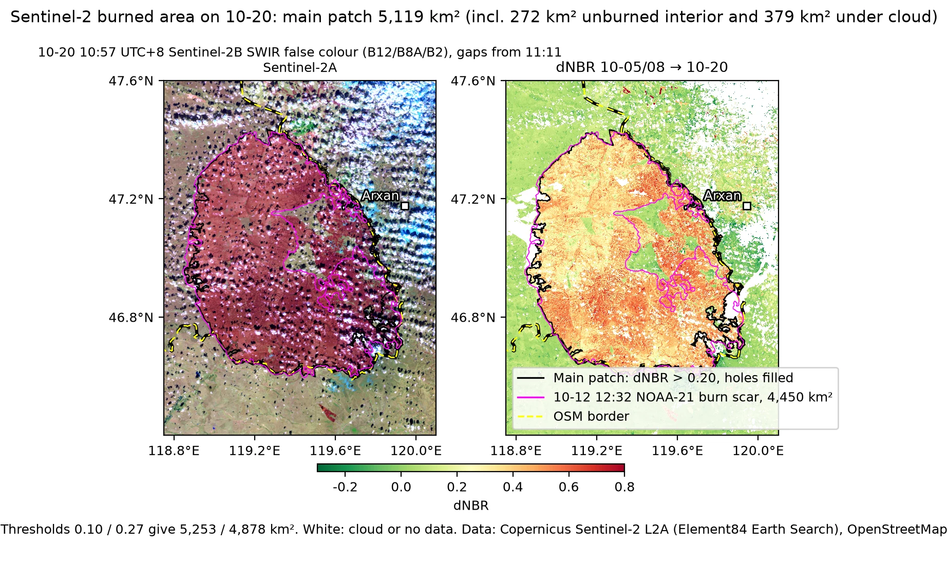
Sentinel-2B at 10:57 and Sentinel-2A at 11:11 on 10-20 passed 14 minutes apart. Cloud cover is 3–10% over the southern half of the fire area and about half over the northern half; after combining the two scenes, 7% of the main burned area has no data. With 10-05 as the pre-fire reference (gaps filled from 10-08, 27 minutes before ignition), dNBR was computed on a 20 m grid, burned pixels were taken as dNBR above a threshold, and the same rules as for the VIIRS burn scars above were applied: opening twice, keeping connected regions of at least 5 km², closing three times, filling holes and taking the largest connected region.
| Threshold | Main patch, km² | Unburned inside, km² | Of which unburned island, km² | Under cloud inside, km² | Share of the 10-12 NOAA-21 scar inside it |
|---|---|---|---|---|---|
| 0.10 | 5,253 | 395 | 238 | 415 | 96% |
| 0.20 | 5,119 | 567 | 272 | 379 | 95% |
| 0.27 | 4,878 | 922 | 339 | 326 | 90% |
Twelve days after ignition and five after extinction, the dNBR of the grassland burn scar is already decreasing: of the pixels inside the 10-12 scar (more than 0.5 km from its edge), only 84% exceed 0.27, 93% exceed 0.20 and 97% exceed 0.10, so 0.20 is used here. In this post’s definition, the main patch of 5,119 km² minus the 272 km² of unburned island gives about 4,850 km²; thresholds of 0.10 and 0.27 give 5,015 and 4,540 km². This is within 1–2% of the 4,905–4,948 km² from VIIRS on 10-14, and the estimate of about 4,900 km² stands. Without subtracting the unburned island, 5,119–5,253 km² is within 1–3% of the 5,288 km² of Mongolia’s Ministry of Environment and Climate Change. 94.5% of the 10-12 NOAA-21 scar lies inside the 10-20 main patch; the area burned after 10-12 is mainly inside the unburned island (about 300 km²) and on the east front. The main patch has 5,052 km² on the Mongolian side and 67 km² on the Chinese side; the latter is discussed in the next section.
The Mongolian Ministry of Environment and Climate Change gives the burned area inside the reserve as 468,965.7 ha, about 4,690 km², or 79.8% of the reserve9, which implies a reserve area of 5,877 km². OSM has no boundary for the Nömrög Strictly Protected Area; the World Database on Protected Areas (WDPA, October 2026 release) does: site ID 93518, IUCN category Ib, reported area 5,877 km², 5,715 km² as computed from the polygon. Overlaying this polygon on the main patch at the 0.20 threshold gives 4,497 km² inside the reserve, 79% of the polygon area and 88% of the main patch, 4% less than Mongolia’s 4,690 km². Counting only pixels above the dNBR threshold, without hole filling, gives 3,637 km² inside the reserve, 64% of the polygon area. The part of the main patch outside the reserve is 622 km², of which 363 km² lies north of 47.3°N.
Compared with the official result of 10-28: inside the reserve, Mongolia gives 4,490 km² and this post 4,497 km², a difference of 0.2%; outside the reserve, Mongolia gives 560 km², and 67 km² of this post’s 622 km² lie on the Chinese side, which leaves 555 km², a difference of 1%; this post’s main patch on the Mongolian side totals 5,052 km², and Mongolia’s total is 5,050 km². This post’s main patch is hole-filled and includes 567 km² of pixels that are unburned at the 0.20 threshold; the report does not say whether Mongolia’s definition is the same. The WDPA polygon is 162 km² smaller than Mongolia’s reserve area, so the split between inside and outside the reserve also depends on the boundary. The report does not say whether Mongolia’s 55,966.8 hectares outside the reserve include the Chinese side.
Burned area near the China–Mongolia border: 54–62 km² on the Chinese side within 2 km of the line
All assessments of burning near the China–Mongolia border use the OSM border line, which is based on LSIB and the median line of boundary rivers. On this section, the commonly used Natural Earth 1:10m border is offset from it by a median of 2.2 km and a maximum of 4.4 km; with the fire pixels up to 09:30 on 10-12, the number of “fire pixels on the Chinese side” is 258 using the OSM line and 602 using the Natural Earth line. Along a 300 km border, a strip one 250–375 m pixel wide corresponds to an area of 75–110 km². By the OSM line, 313 FIRMS fire pixels from 10-08 to 14:35 on 10-12 fall on the Chinese side. Their median distance past the line is 0.35 km; 71 are more than 0.75 km past the line and 12 are more than 1.5 km past it. The 375 m pixel size plus a geolocation error of 0.2–0.5 km can account for most of them. After 14:35 on 10-12, none of this fire’s pixels are on the Chinese side. The 3 MODIS fire pixels on the Chinese side south of the main fire on 10-15 belong to the separate fire described above.
On the 10-13 Terra image, burn scar outside the OSM line totals 26 km², of which 3.6 km² is more than 1 km from the line and 1.6 km² is more than 2 km from it, up to 3.2 km. On the two 10-12 VIIRS scenes it is 39–40 km², up to 4.2 km from the line. The difference between them is within pixel error, and there is no new cross-border area. Apart from the south section and the section west of Arxan listed in the table below, the remaining parts outside the line are narrow margins 0.2–1.2 km wide along the line, within the error of 1–3 pixels.
On the two fully clear 10-14 VIIRS scenes, burn scar outside the OSM line is 58–60 km², about 20 km² more than on 10-12. The new burn scar on the Chinese side, outside the 10-12 burn scar, is 24.5 km² (S-NPP) and 26.7 km² (NOAA-20). It consists entirely of narrow strips within 1.3 km of the line, and most of it already appears on 10-12 S-NPP or 10-13 Terra. On the east side, at 46.85–47.13°N, 119.76–119.92°E, there are seven pieces totaling about 14 km², with median distances from the line of 0.1–0.4 km. In the south section, the pieces at 46.60–46.66°N belong to the burned area already listed for the south section in the table below. Only one piece, 1.2 km², is absent from all earlier scenes. It is at 47.102–47.129°N, 119.757–119.772°E, at the southern end of the southern cluster west of Arxan, with a median distance from the line of 0.23 km and a maximum of 0.74 km. It is at pixel scale, and confidence is low. There is no new large cross-border area on 10-14. On the Sentinel-2C image at 11:05 on 10-15, 99–100% of the Chinese side of the south section and of the section west of Arxan is cloud-covered, so this scene cannot be used to assess border crossing.
VIIRS active fire (NASA) detections on 10-12 daytime, border section west of Arxan (marker size ∝ FRP, colour = overpass time).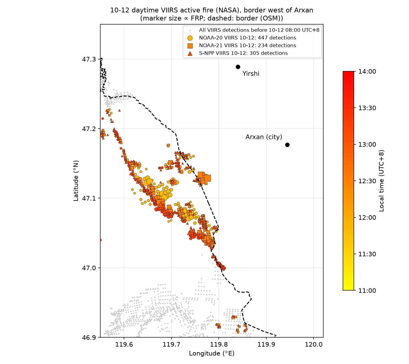
| Section | Observation | Assessment |
|---|---|---|
| South section, 46.61–46.64°N, 119.39–119.51°E (East Ujimqin Banner, Xilin Gol League) | Sentinel-2 dNBR on 10-10 shows a main body of about 12 km² outside the line, at a median of 1.6 km and up to 3.6 km from the line, absent on 10-05; its southern edge lies on a strip of land 100–190 m wide that existed before the fire. It burned between the night of 10-09 and the morning of 10-10, and only 2 FIRMS fire pixels fell outside the line over the whole period | Burned area on the Chinese side confirmed; consistent with the backburning operations reported publicly by the East Ujimqin Banner authorities; see below |
| Near the Arxan border crossing, 47.26–47.33°N | Fire pixels run along the boundary river, all on the OSM line or within 0.5 km of it on the Mongolian side | The fire line stopped at the boundary river and did not enter China |
| Southern cluster west of Arxan, 47.12–47.14°N, 119.76–119.78°E | The near-nadir NOAA-21 overpass at 12:30 on 10-12 (pixel size 0.44 km) detected about 2.4 km² of open flame east of the border; the farthest fire-pixel center was 1.4 km past the line (the fire pixels more than 0.75 km past the line are 0.8–1.4 km past it); in the false color the active-fire pixels extend 0.5–1 km east, with a maximum FRP of 363 MW; the image check box is 47.115–47.14°N, 119.745–119.80°E; in the overpasses before and after, the burn scar threshold gives 0, and the area east of the line is still green vegetation. Burn scar outside the line is 0 km² on the 250–500 m imagery of 10-12 and 10-13. On 10-13 Sentinel-2B the Chinese side is only 16% clear, and 0.11 km² of the 0.55 km² clear area is burned. The area is in Arxan City, Hinggan League; on pre-fire Sentinel-2 this section has no continuous firebreak 100–300 m wide, only a river channel and a parallel dirt road 0.1–0.6 km inside the border | Either a border crossing or backburning on the Chinese side is possible; extent ≤ 2–3 km²; Hinggan League reported backburning along the border patrol road from 12:40 on 10-11, and the fire pixels east of the line at 12:30 on 10-12 came after the backburning began |
| Northern cluster west of Arxan, 47.155–47.19°N, 119.70–119.76°E | Fire pixels on 10-12 are 1.0–1.5 km from the line. On 10-13 Sentinel-2B the area is 67% clear; dNBR > 0.27 east of the line covers about 0.9 km², made up of several small pieces of 0.1–0.3 km², 0.2–1.3 km from the line | About 0.9 km² burned on the Chinese side; inferred to be fire that crossed the border by about 1 km and was stopped by the backburn firebreak along the river valley; see below |
| East and southeast sections | A few pixels 1–3 km outside the line from 10-11 to early 10-12; some fall on geometric dark patches that existed before the fire, possibly firebreaks from planned burning or plowed land | Single-pixel scale, no contiguous entry |
| 10-20 Sentinel-2 check | 20 m dNBR: 54–62 km² east of the line within 2 km, 34–38 km² within 0.5 km; west of Arxan 11.5 km² (up to 2.2 km), east front 5.9 km² (1.7 km), south section 21.2 km² (3.6 km), all continuous with the Mongolian scar | A continuous burned band on the Chinese side along the line; fire from Mongolia and backburning cannot be separated, see below |
| Total | On the two clearest 10-12 scenes, burn scar outside the line is 39–40 km², of which only 7–10 km² is more than 1 km from the line; 26 km² on 10-13 Terra; 58–60 km² on the two 10-14 VIIRS scenes, where the additions are all narrow strips within 1.3 km of the line | No large area entered China; no new cross-border area |
South section: burn scar edge (magenta) and border (OSM, yellow line) on four GIBS scenes at 250–375 m from 10-12 and 10-13. Each panel title gives the burned area outside the border line (OSM) inside the box and the farthest distance from the line. The 10-13 Terra scene uses the relaxed green-channel threshold; the edge error is 1–2 pixels (0.4–1 km).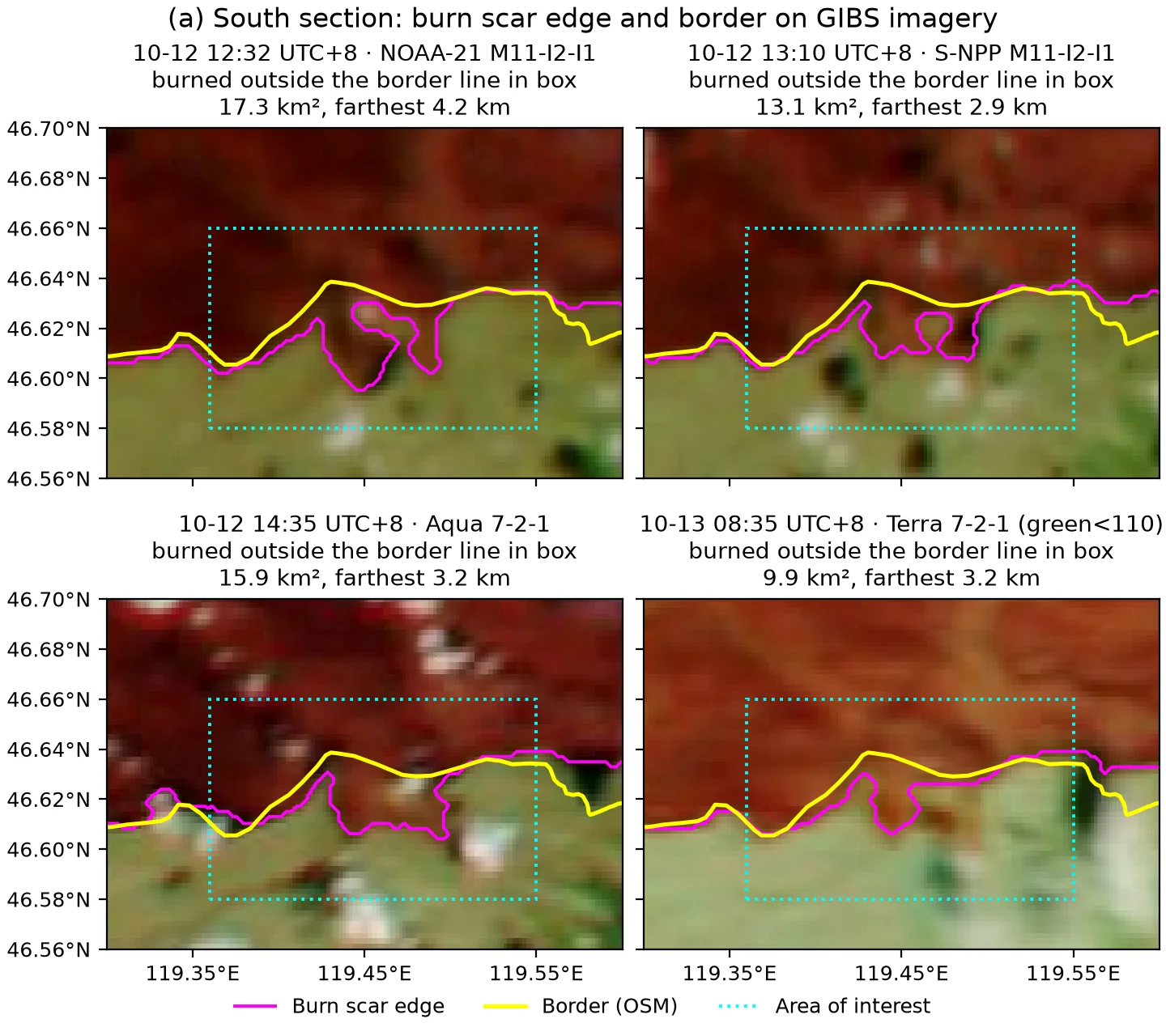
West of Arxan: the same four scenes, legend as above. In all four scenes the burned area outside the border line inside the box is 0 km².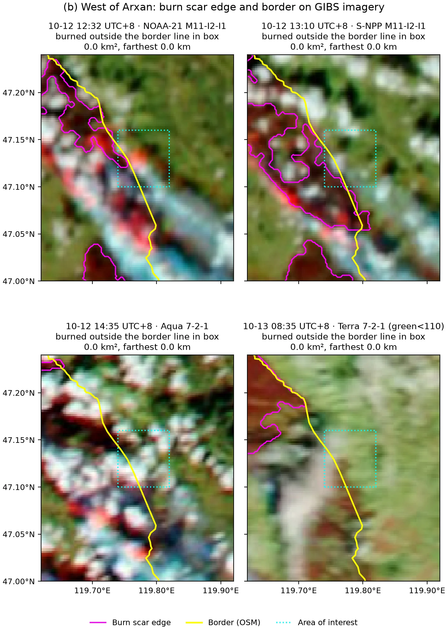
Near the Arxan border crossing: before the fire (10-05) and during the fire (10-10), with the border and VIIRS/MODIS active fire (NASA) detections. White triangles: Sümber (Сүмбэр боомт) and Arxan border ports. Thin white lines: roads on the Mongolian side. Both from the OSM 2026-10-25 snapshot, © OpenStreetMap contributors (ODbL).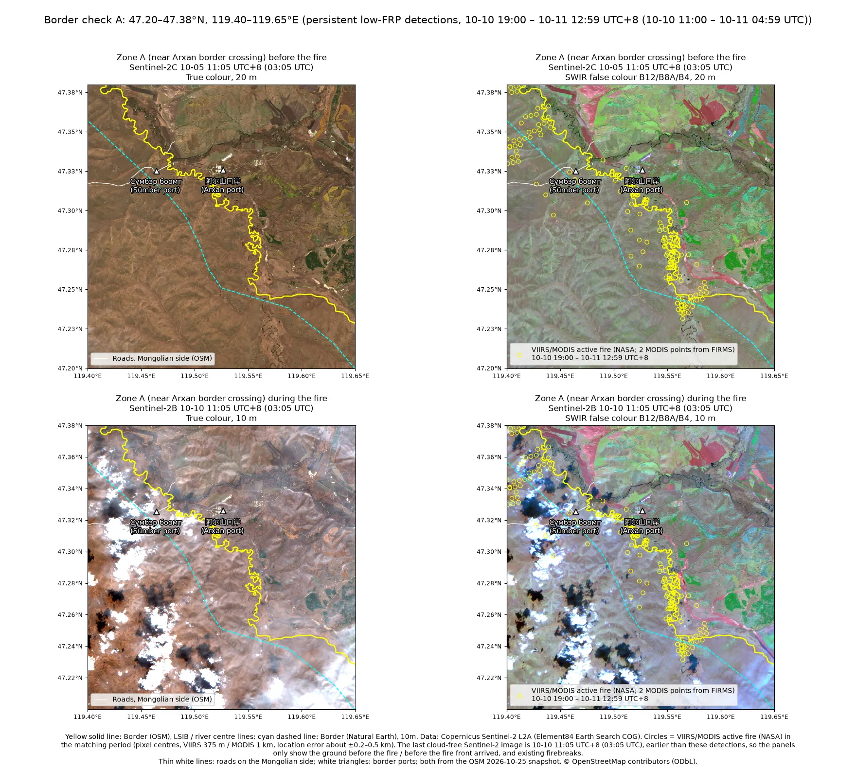
Scene-by-scene check of the two fire-detection clusters that cross the border west of Arxan, false colour, five scenes of 10-12. Yellow line: border (OSM); magenta dashed boxes: the two check boxes east of the border; white circles: FIRMS fire detections from the same overpass on the Mongolian side; cyan circles: fire detections east of the OSM line. Bright red and orange: active fire; dark reddish brown: burn scar; cyan: smoke.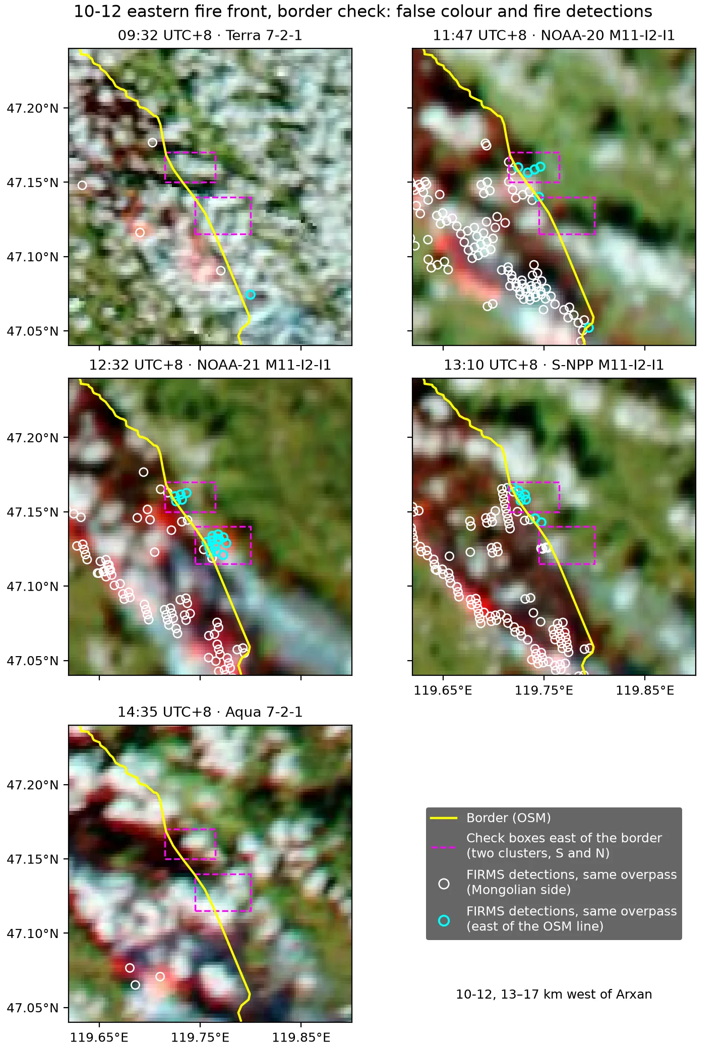
The same five scenes in true colour, used to tell cloud, smoke and burn scar apart. Yellow line and magenta dashed boxes as above.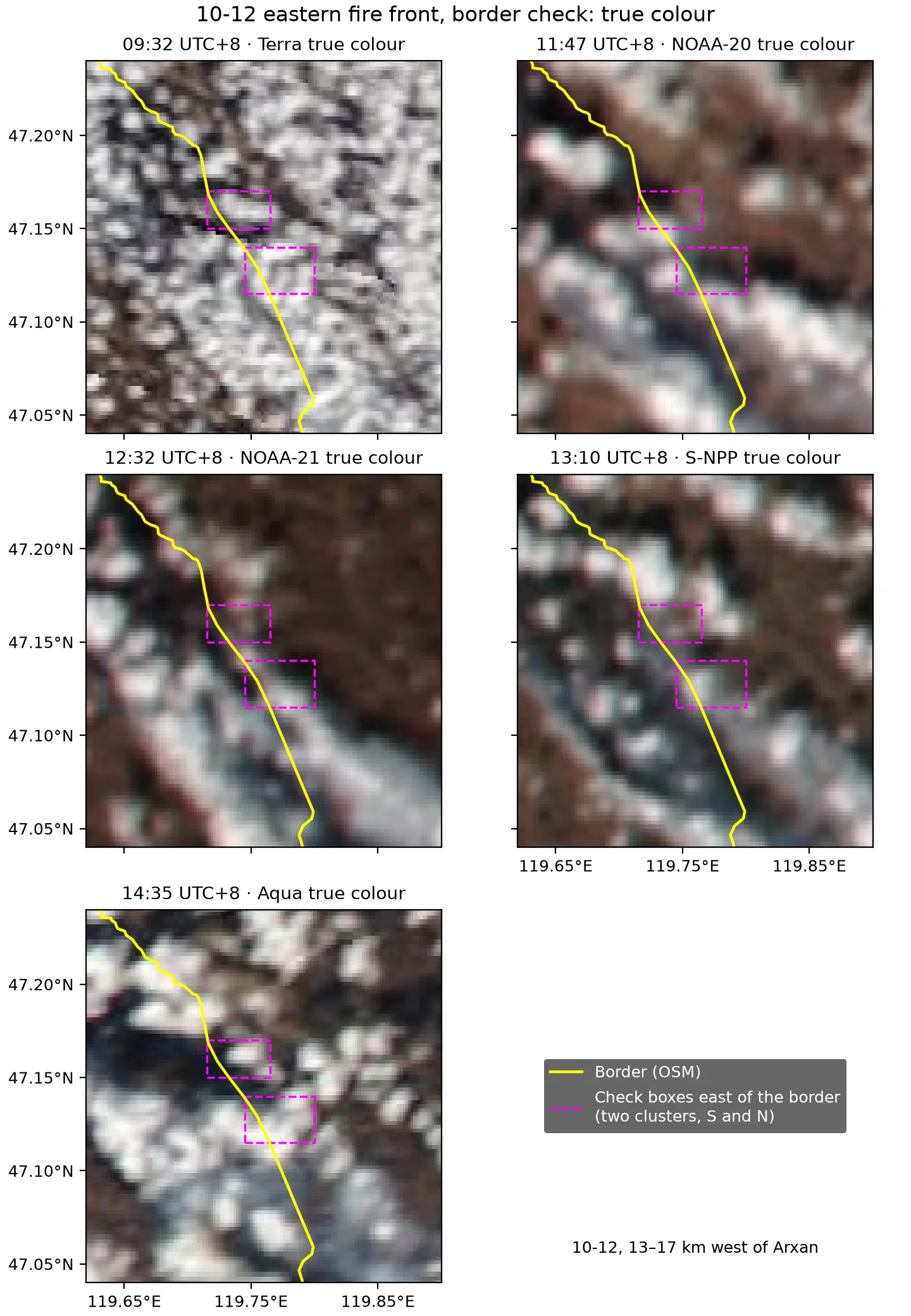
The Chinese official statements at each level are quoted above, in the section on the Chinese border response. Note: at the large scale these statements agree with the satellite assessment, which finds no contiguous burned area entering China. However, west of Arxan, VIIRS fire pixels crossed the border at midday on 10-12, up to 1.5 km past it, and Sentinel-2 on 10-20 shows about 11.5 km² burned on the Chinese side of this section, up to 2.2 km from the line. In the south section about 21 km² burned on the East Ujimqin Banner side, of which the main patch of about 13 km² is consistent with backburning, and on the east front a further 6 km² or so; see the 10-20 check below. The official statements do not mention these places. The Xinhua report of 10-1312 lists the measures as “suppression and blocking along the line, widening firebreaks, and clearing combustible material” (沿线扑救堵截、拓宽隔离带、清理可燃物). The statements of the Arxan City Emergency Management Bureau and the Hinggan League Fire and Rescue Mobile Detachment quoted by the Beijing News on 10-1115 mention only border deployment and blocking. The backburning on the Hinggan League side is described in the report of the Hinggan League Forestry and Grassland Bureau on 10-1616: from 12:40 on 10-11 it “used the border patrol road to carry out precise counter-burning in the hundred-meter buffer between the border wire fence and the firebreak” (依托边境巡逻路,对国境铁丝网至防火隔离带百米缓冲区开展精准对冲点烧作业), including 23 km in the Arxan City sector and 21 km in the Wuchagou sector (Xinhua Inner Mongolia on 10-1417 also reported the 21 km at Wuchagou). A firefighter with the Arxan City Forestry and Grassland Bureau interviewed by Southern Weekly on 10-1814 said that the firebreak is backburned routinely every late autumn: “As originally planned, the backburning of the firebreak was scheduled for October 10. But that afternoon they saw a smoke column and fire glow rising in the direction of Mongolia, and immediately switched to fire watch” (按原计划,阻隔带的点烧定在 10 月 10 日进行。但当天下午,他们发现了蒙古国方向腾起烟柱和火光,随即转入火场戒备); by the Hinggan League Forestry and Grassland Bureau’s report, the backburning took place after 12:40 on 10-11. A National Forestry and Grassland Administration report of 2025-1118 says Hinggan League has built a 131 km firebreak, 100–300 m wide, along the China–Mongolia border.
Burned area on the Chinese side in the south section
Southern border zoom, Sentinel-2: true colour and SWIR false colour (B12/B8A/B4) before the fire on 10-05 and during the fire on 10-10, and SWIR false colour on the ignition day 10-08; the last panel is dNBR (10-05→10-10). Yellow dashed line: border (OSM); white arrow: a strip already present on 10-05, 100–190 m wide and 2.5–3.3 km from the border.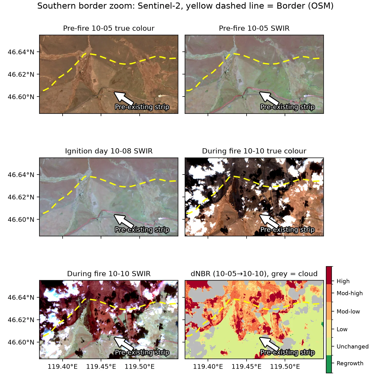
By the geoBoundaries county-level boundaries, this burned area lies in East Ujimqin Banner, Xilin Gol League. It is 44–53 km from the boundary of Horqin Right Front Banner, Hinggan League, and 53–59 km from the boundary of Arxan City. The CNR Xilin Gol report of 10-1219 covers the response on the East Ujimqin Banner section: “relying on the existing firebreaks, firefighters were organized to continue backburning in areas where conditions allowed backburning to be done safely” (依托现有防火隔离带,组织扑火人员对具备安全点烧条件的区域,继续实施点烧作业).
- On the pre-fire images of 10-05 and 10-08, a strip of land 100–190 m wide with parallel stripes already runs along a dirt road 2.5–3.3 km south of the border. Its appearance matches a firebreak made by plowing.
- The southern edge of the burned area at 11:05 on 10-10 lies on this strip. For example, at 119.455°E the southern edge of the burn scar is at 46.6087°N and the northern edge of the strip is at 46.6085°N. To the north, the burned area is continuous with the Mongolian burn scar, with no unburned gap at the border. On the west side it is bounded by a river valley.
| Time (UTC+8) | Observation |
|---|---|
| 10-09 12:44–13:27 | The Mongolian fire front is 5–8 km north of the border, total FRP about 10 GW |
| 10-09 22:00–10-10 06:00 | 10 m wind over the fire area 0.1–2.3 m/s, turning southerly (150–210°) after midnight; relative humidity 78–92% |
| 10-10 01:43, 02:41 | VIIRS has only 1 fire pixel outside the line (0.4 km from it, 1 MW) and 3 inside |
| 10-10 09:52 | MODIS fire pixels reach the border (0.2 km from the line) |
| 10-10 11:05 | On Sentinel-2 the burned area on the Chinese side has already formed |
The shape of the burn scar alone cannot distinguish between two cases. In the first, the Mongolian fire crossed the border and was stopped by the firebreak. In the second, the Chinese side backburned north from the firebreak, and the backburn merged with the incoming fire. In both cases the southern edge is straight. The conditions during burning fit the second case better. This area of about 12 km² formed at night, with near-calm wind, relative humidity of 78–92%, and a southerly wind in the second half of the night. A southerly wind pushes fire north, opposite to the direction in which this burned area extended south. In addition, the two nighttime VIIRS overpasses detected almost no open flame. Under these conditions, it is unlikely that the Mongolian fire advanced 3 km south against the wind. The specific backburning locations and times have not been published, so they cannot be matched to the burned area piece by piece.
On the Sentinel-2B image at 11:15 on 10-13, about 56% of the Chinese side of this section is covered by cumulus and cloud shadow. Among the pixels that are clear in both the 10-10 and 10-13 scenes (34% of the Chinese side), new dNBR > 0.27 since 10-10 totals 0.14 km², all in scattered pixels of 0.01–0.02 km². The burned area did not grow south or east. The clear areas show no SWIR signal at active-fire levels.
South section, Sentinel-2B on 10-13: 10-10 true colour, 10-13 true colour and SWIR, and dNBR (10-05→10-13; grey = cloud and cloud shadow). Yellow dashed line: border (OSM); arrow: the strip that existed before the fire.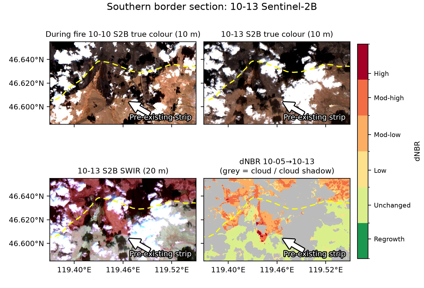
Burned area on the Chinese side in the section west of Arxan
On the Sentinel-2B image at 11:15 on 10-13, about 77% of the Chinese side of the section west of Arxan (47.08–47.22°N, 119.66–119.84°E) is covered by cumulus and cloud shadow. The scene classification does not separate cloud shadow from burn scar, so here the two are separated using SWIR: cloud shadow has low B12 reflectance, and burn scar does not.
Section west of Arxan, Sentinel-2B on 10-13: pre-fire 10-05 true colour, 10-13 true colour and SWIR, and dNBR (10-05→10-13; grey = cloud and cloud shadow). Yellow dashed line: border (OSM); arrow: burned area east of the line that joins the burn scar on the Mongolian side.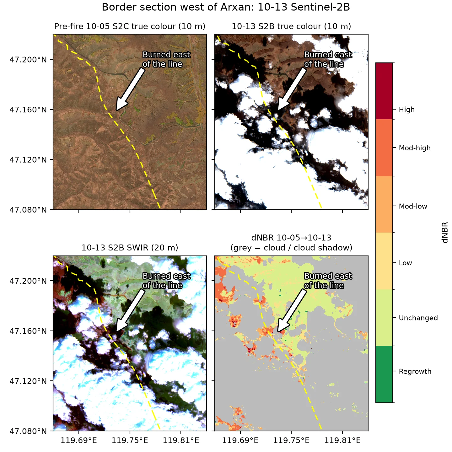
- The northern part, 47.155–47.19°N, 119.70–119.76°E, is 67% clear. dNBR > 0.27 east of the line covers about 0.9 km², split into several small pieces of 0.1–0.3 km². The largest piece, at 47.155–47.165°N, 119.72–119.745°E, connects to the Mongolian burn scar to the west and lies 0.2–1.3 km from the line. Its eastern edge is roughly at the river valley inside the border.
- This burned area has an irregular shape, with no straight edge parallel to the border. Its position matches the 5–18 fire pixels detected on the Chinese side in the four daytime overpasses on 10-12 (up to 1.5 km from the line). The burned area extends east from the border, and its eastern edge stops at the river valley inside the border; it has no straight edge parallel to the border like a backburn strip. The Hinggan League Forestry and Grassland Bureau reported backburning “along the border patrol road” (依托边境巡逻路) from 12:40 on 10-11, about 100 m wide16; near the southern cluster, the patrol road runs along the river channel inside the border (see the table above). Inference: the Mongolian fire crossed the border by about 1 km during the day on 10-12 and was stopped at the river valley by the firebreak created by the backburning. The 10-13 imagery does not resolve a backburn strip along the valley, and most of the area east of the northern cluster is cloud-covered, so no imagery directly supports this inference.
- The narrow strip to the south, at 47.12–47.14°N, 119.76–119.78°E, is only 16% clear on the Chinese side, which is not enough to judge its shape; its cause is undetermined. The parallel dirt road 0.1–0.6 km inside the border may be the road along which the backburning was carried out, the “border patrol road” (边境巡逻路) of the report, and the strip could be a backburn strip, but most of it is cloud-covered on the 10-13 image and this cannot be confirmed. The clear fraction over the whole 47.10–47.16°N range is 13%.
- The clear areas show no SWIR signal at active-fire levels.
An area of 0.9 km² is smaller than 1–3 VIIRS or MODIS pixels, so moderate-resolution imagery cannot resolve burned area of this size. The 10 m imagery can resolve this burned area east of the line.
Check on Sentinel-2 of 10-20
Sentinel-2 on 10-20, three border sections: SWIR false colour and dNBR (10-05/08→10-20) west of Arxan, on the east front and in the south section. Black: patches with dNBR > 0.20 east of the line, ≥ 0.05 km² and reaching within 0.5 km of the line; panel titles give their area and farthest distance from the line. Yellow dashed: OSM border; magenta: 10-12 NOAA-21 burn scar; white: cloud or no data.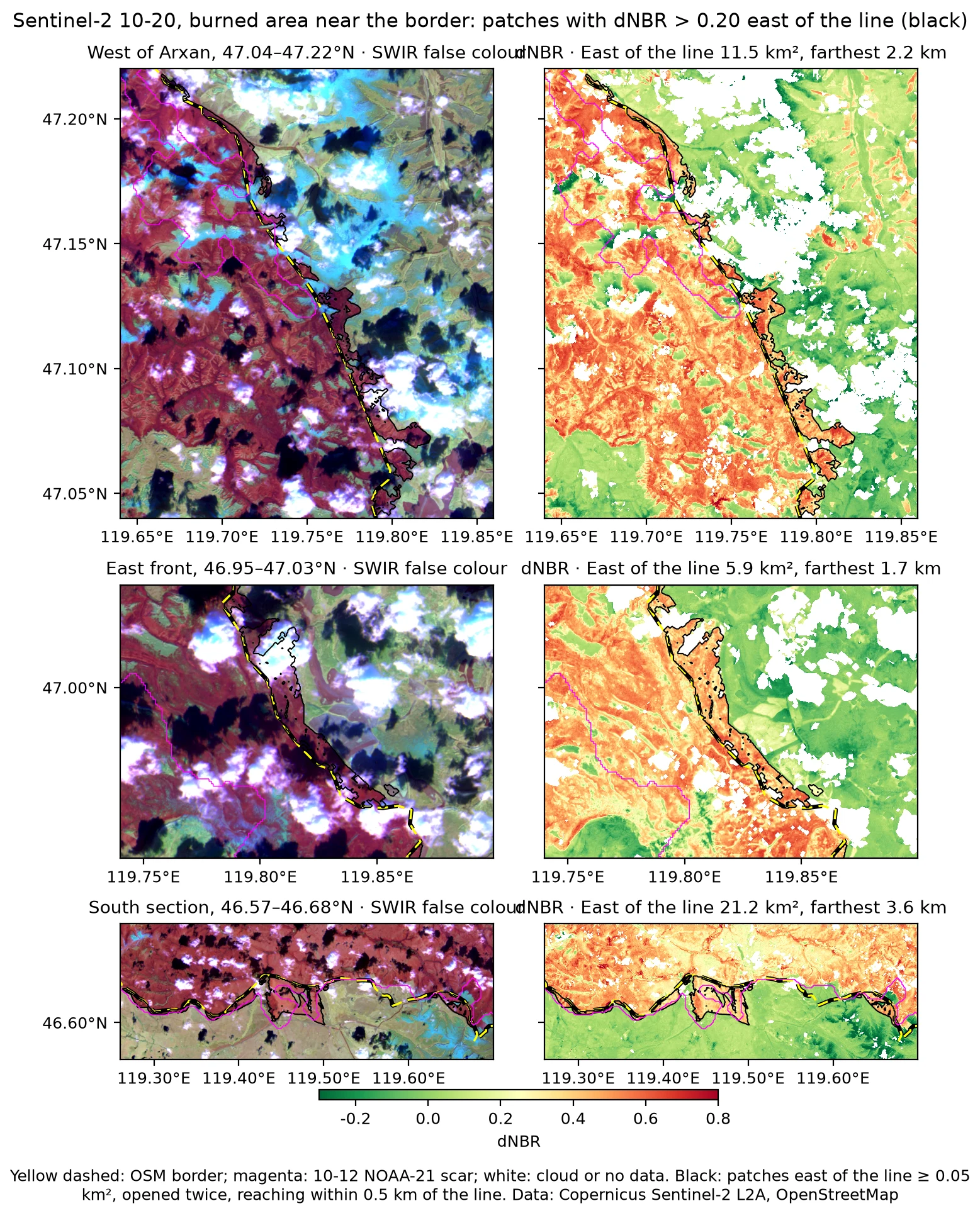
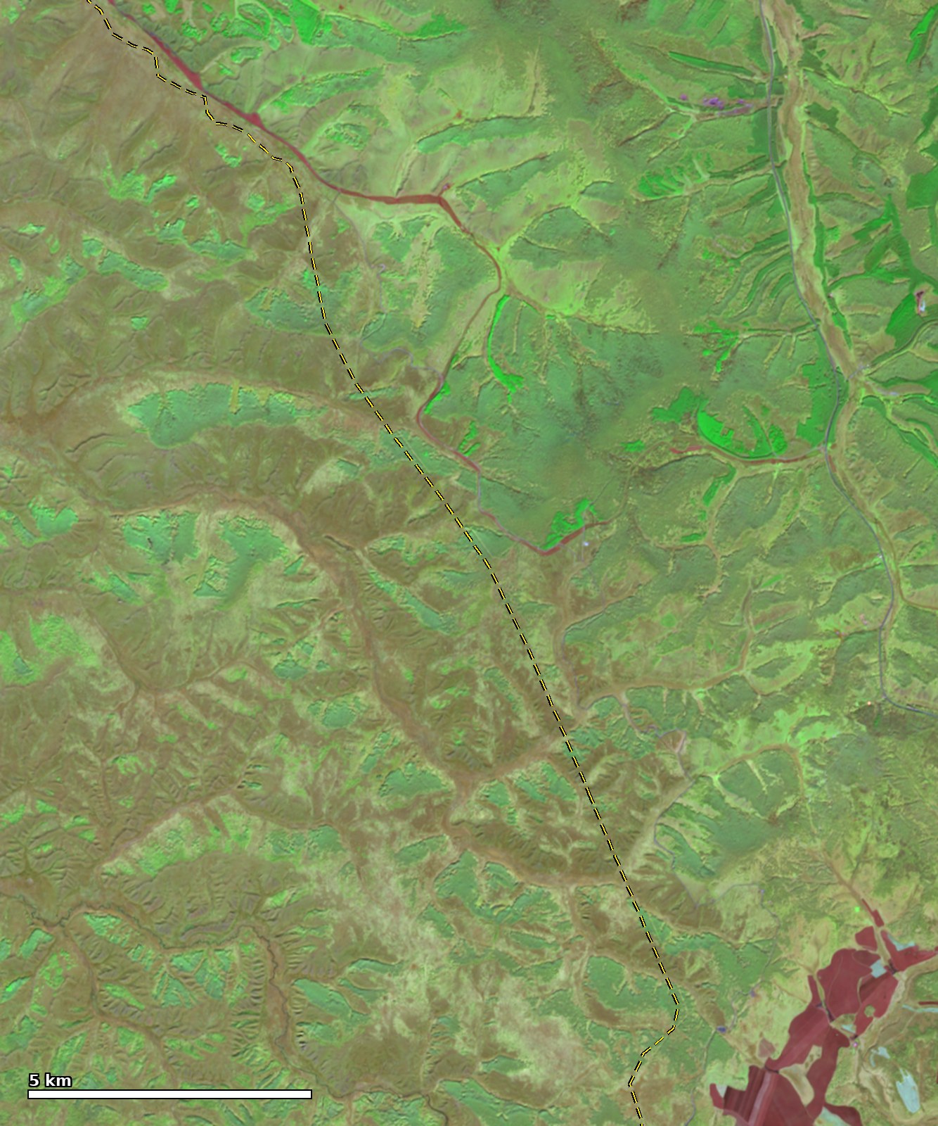 Before, 10-05 Sentinel-2C SWIR
After, 10-20 Sentinel-2B SWIR
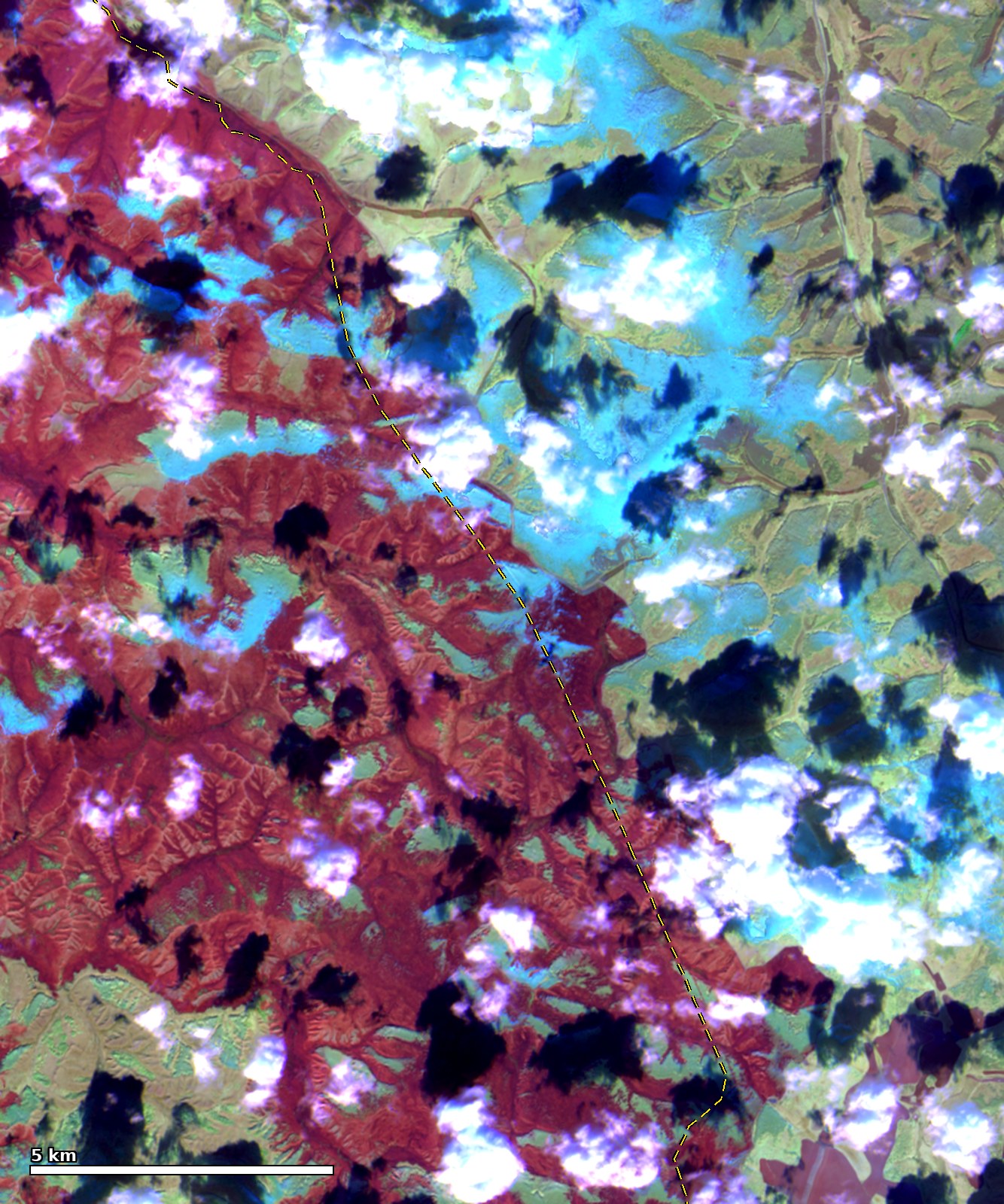
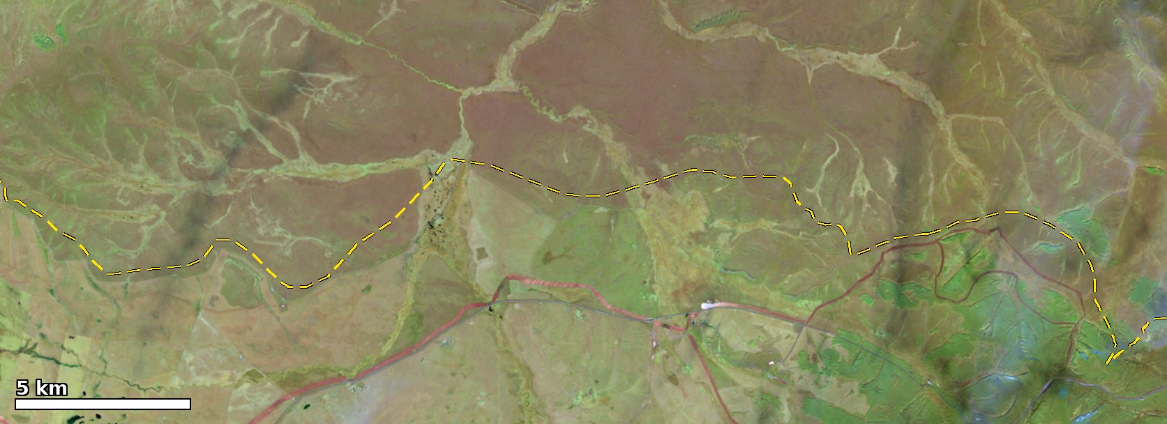 Before, 10-05 Sentinel-2C SWIR
After, 10-20 Sentinel-2B SWIR
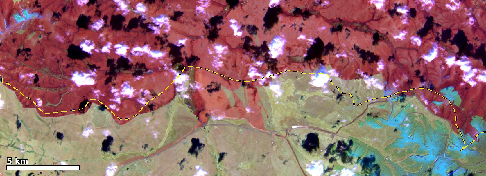
Sentinel-2B at 10:57 and Sentinel-2A at 11:11 on 10-20 are the first scenes after the fire went out with most of the border line clear: about 70% of the Chinese side is clear in the section west of Arxan and 97% in the south section. On the 20 m dNBR (pre-fire 10-05 and 10-08, post-fire 10-20; method in the burned-area section), the burned patches of at least 0.05 km² east of the OSM line are distributed by distance from the line as follows:
| Distance from the OSM line | Burned east of the line, km² (thresholds 0.27–0.20) |
|---|---|
| 0–0.25 km | 20–22 |
| 0.25–0.5 km | 15–17 |
| 0.5–1 km | 12–15 |
| 1–2 km | 7.5–9.6 |
| 2–3 km | 4.4–5.9 |
Within 2 km the total is 54–62 km², close to the 58–60 km² of the 10-14 VIIRS scenes, but at 20 m pixel size these areas can no longer be explained by pixel geometry. The 34–38 km² within 0.5 km runs along the whole line and is consistent with the backburning that Hinggan League reported along the border patrol road in “the hundred-metre buffer between the border wire fence and the firebreak”; the positional error of the border line itself is of the same order. The parts more than 1 km from the line are concentrated in three sections:
- West of Arxan (47.04–47.22°N): 11.5 km² east of the line and connected to it, up to 2.2 km. Between 47.05 and 47.14°N there is a continuous burned band 0.5–2 km wide along the line, which includes the narrow strip that was cloud-covered on 10-13 and extends 1–2 km east of the line; the piece in the north at 47.155–47.19°N is the roughly 0.9 km² seen on 10-13. NOAA-21 at 12:30 on 10-12 detected fire pixels 0.8–1.4 km past the line here, and the burned band matches their position.
- East front (46.95–47.03°N): 5.9 km², up to 1.7 km, a band 0.3–1 km wide along the line. The 10-14 VIIRS scenes already showed narrow strips 0.1–0.4 km from the line here.
- South section (46.57–46.68°N): 21.2 km², up to 3.6 km, of which 12.7 km² is the main patch discussed above, with a median distance of 1.6 km; the rest are strips 0.2–1 km wide along the line.
In all three sections the burned area is continuous with the Mongolian burn scar, with no unburned gap on the border. Fire that crossed the border and was stopped by a backburn strip, and backburning from the patrol road westward that met the oncoming fire, leave the same burn-scar shape, and the 10-20 imagery cannot separate them. The burned band west of Arxan is 0.5–2 km wide, wider than the reported hundred-metre buffer: if it is all backburning, the backburn line lay 0.5–2 km east of the border; if it is the oncoming fire, the fire crossed the border by 0.5–2 km.
Smoke on the Chinese side: PM2.5 in Hailar and Baicheng, GEFS-Aerosols simulation
On the day of ignition, 10-08, the smoke from the Nömrög fire did not reach the Chinese side. From 10-09 the smoke plume turned southeast, east and northeast with the wind; see the smoke plume section above. Arxan City has no national air-quality monitoring station, and Hinggan League has had no data for a long time in the air-quality data used here. The effect of the smoke on the Chinese side therefore has to be assessed by combining satellite data, back trajectories, visibility at weather stations and official statements.
Weather station observations:
- The Mongolian station Khalkh-Gol (44313, northwest of the fire area) reported smoke twice: at 08:00 on 10-09 with visibility of 20 km, and at 11:00 on 10-10 with visibility of 2 km. Both times the wind was from the southeast (130–140°), blowing from the fire area toward the station.
- At Arxan station (50727), visibility was 30 km (the upper limit of the code) all day on 10-09, and there was rain and snow from the afternoon of 10-10 to the morning of 10-11. During the day on 10-11 the wind turned south-southwest to southwest, blowing from the direction of the fire area, with relative humidity of 20–45%. Visibility was 13–21 km at 11:00, 17:00 and 20:00, and at 23:00 it fell to 3.9 km with haze reported. The air was dry, which rules out fog and mist; the observations are consistent with smoke. From 10-12 the wind turned northwest at 5–8 m/s, and visibility returned to 30 km.
Smoke transport and air quality: the PM2.5 peaks at Baicheng and Hailar both contain smoke from this fire. For Baicheng there are three lines of evidence, the satellite smoke plume, the back trajectories and the model smoke plume; the model plume arrives late. For Hailar the satellite evidence is weaker, and the timing and magnitude of the model smoke plume agree with the observations. The back trajectories are computed kinematically from hourly ECMWF IFS 0.25° winds (10 m, 925, 850 and 700 hPa), without vertical motion or diffusion; over about 10 hours the error is a few tens of km.
Sentinel-5P TROPOMI carbon monoxide total column (top) and UV aerosol index (bottom) on 10-11 and 10-12; times in brackets are the two overpasses. Overlaid are 36-hour back trajectories computed from hourly ECMWF winds: on 10-11 arriving at Hailar at 09:00 UTC+8 (10 m, 925, 850 and 700 hPa), on 10-12 arriving at Baicheng at 19:00 UTC+8 (925, 850 and 700 hPa). Black dashed line: China–Mongolia border (OSM).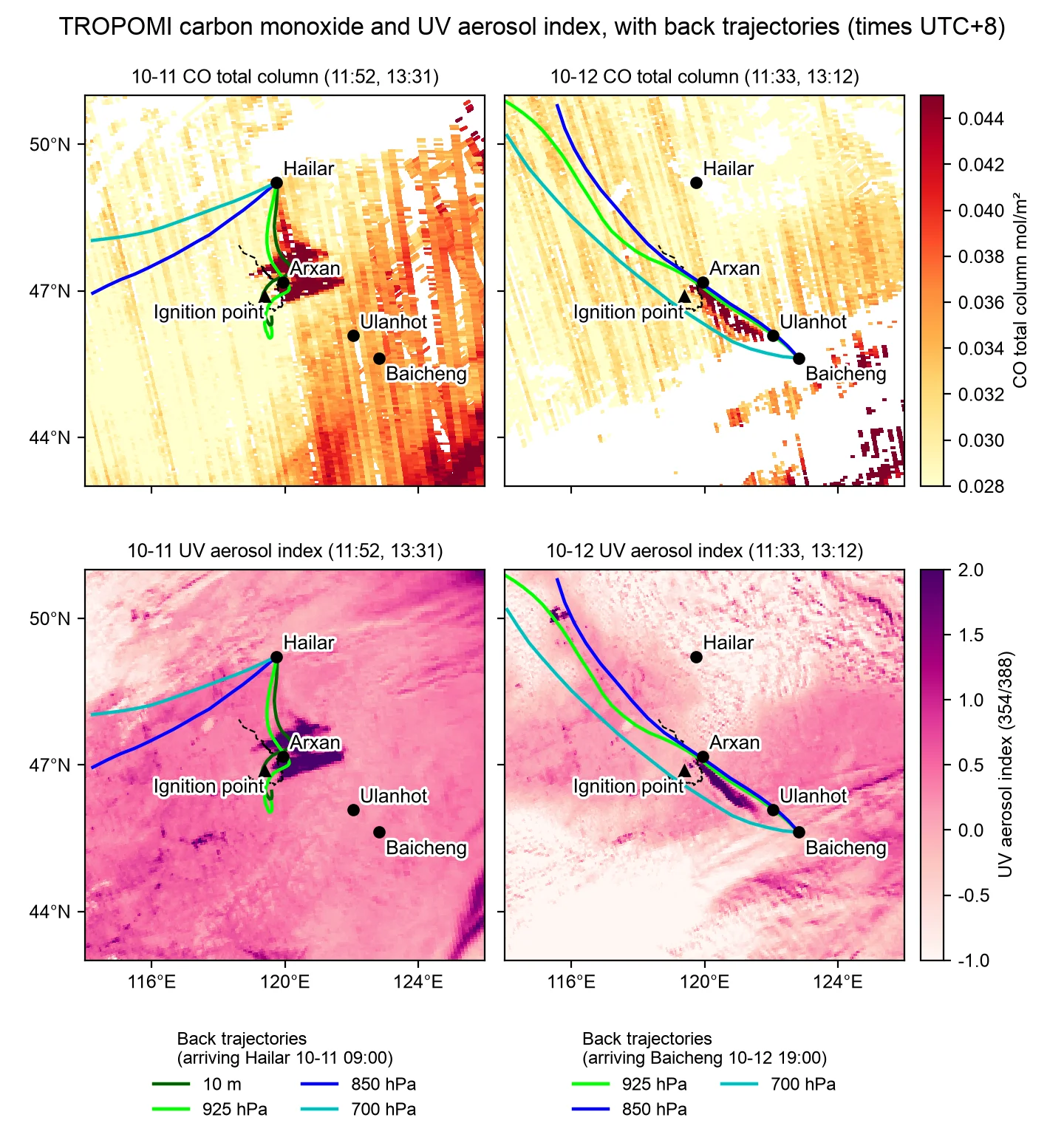
Hourly PM2.5, PM10 and CO at Hulunbuir (Hailar) and Baicheng (China national real-time city air-quality release, via the quotsoft.net mirror). Orange: peak periods when the back trajectories pass over the fire area.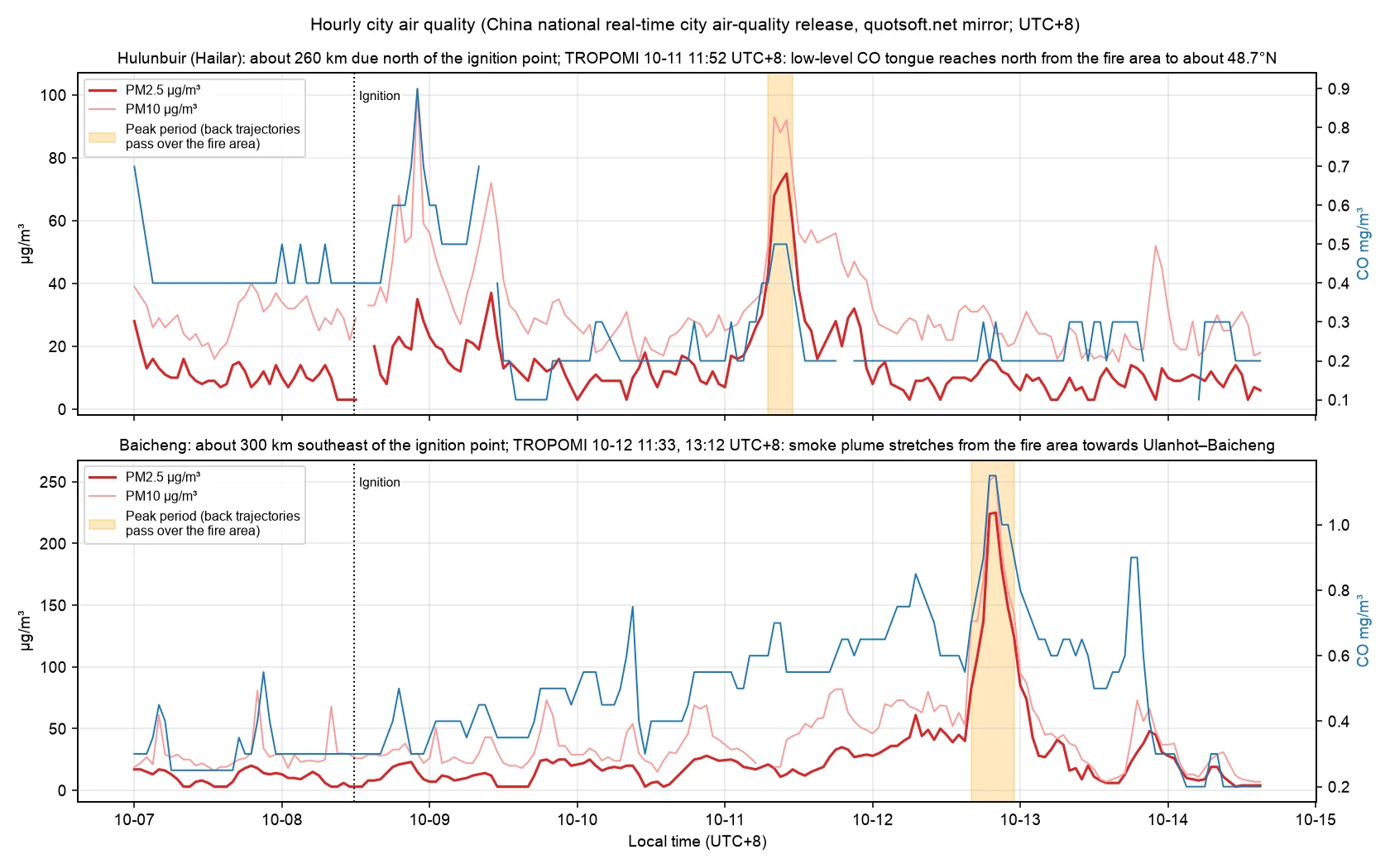
- Baicheng (Jilin Province, about 300 km southeast of the fire area): from 16:00 to 23:00 on 10-12, PM2.5 rose from 82 to 225 µg/m³, PM10 reached 255 µg/m³, and CO rose from 0.8 to 1.1 mg/m³. This event very likely includes smoke from this fire:
- On the Aqua true color image at about 13:30 on 10-12, the smoke plume extends from the fire area, south of Arxan, to near Ulanhot. In the two TROPOMI orbits at 11:33 and 13:12, the high-value bands of carbon monoxide and UV aerosol index have the same orientation, and high aerosol index values reach about 46.2°N, 121.7°E. MODIS MAIAC aerosol optical depth is elevated along the plume.
- The back trajectories arriving at Baicheng at 16:00, 19:00 and 22:00 all pass over the fire area at the 10 m, 925 hPa and 850 hPa levels, and two of them pass over it at 700 hPa. The time from leaving the fire area to arrival is about 6–12 hours, which matches the peak period.
- Within about 100 km of Baicheng, FIRMS had only scattered small fire pixels on 10-10 and 10-11, 15 in total and no more than 32 MW per overpass, and none on 10-12. This fire was at the GW level over the same period. A contribution from local burning cannot be fully excluded, but it is much smaller in magnitude.
- The concentration jumped even though the air behind the cold front was otherwise clean. The PM2.5 to PM10 ratio was about 0.88, and CO rose at the same time, which also fits a combustion smoke plume.
- Hulunbuir (Hailar, about 260 km north of the fire area): from 07:00 to 11:00 on 10-11, PM2.5 rose to 43–75 µg/m³, compared with mostly 3–25 µg/m³ from 10-07 to 10-10, and CO rose from 0.2 to 0.5 mg/m³. This event also includes smoke from this fire. The satellite evidence is weaker than for Baicheng, and the model evidence is stronger (see the GEFS-Aerosols simulation below):
- The 10 m and 925 hPa trajectories arriving at Hailar at 07:00, 09:00 and 11:00 all passed over the fire area about 10 hours earlier, during the period of strongest fire activity on 10-10. The airflow at 850 hPa and above came from central Mongolia and did not pass over the fire area. Arxan station had a southerly wind at 11:00 on 10-11, consistent with the low-level trajectories.
- At 11:52 on 10-11, TROPOMI shows a tongue of high carbon monoxide extending north from the fire area to about 48.7°N, about 50 km from Hailar. This branch has no aerosol index signal. The UV aerosol index is insensitive to smoke near the ground. Inference: this is low-level smoke near the surface.
- Within about 100 km of Hailar, FIRMS had no fire pixels from 10-10 to 10-12.
- Uncertainties: the satellite overpass is 1–5 hours after the peak. The fire area is at about 800–1,000 m elevation, so 925 hPa is close to the ground, and the low-level trajectories have large errors. Under the morning inversion, local emissions can also raise concentrations, but the model’s no-fire control at this time is only 5–9 µg/m³.
- Hailar had another increase from the night of 10-08 to the morning of 10-09, with PM10 of about 100 µg/m³ and CO of about 0.9 mg/m³ but PM2.5 of only 35 µg/m³. It was dominated by coarse particles, and its source is unknown.
- Hinggan League (Ulanhot) has no national monitoring station data. On the afternoon of 10-12 the satellite smoke plume passed near Ulanhot, and the back trajectories arriving at Ulanhot at 14:00 and 17:00 passed over the fire area at all four levels, taking about 3–7 hours. This is an inference from satellite data and the model; there are no ground measurements.
GEFS-Aerosols simulation
NOAA GEFS-Aerosols (the chemistry version of GEFSv12, control forecast, 0.25°, 3-hourly) takes its fire emissions from GBBEPx, which estimates them from satellite FRP. All runs from 10-09 12Z onward include emissions from this fire. The column total of organic particulate matter over the fire area at initialization was 16–21 t before 10-09 00Z, 113 t at 10-09 12Z, a maximum of 613 t at 10-11 00Z, and 107 t at 10-12 00Z. The 10-08 00Z run was initialized before ignition and does not include emissions from this fire through 10-13 00Z, so it serves below as the no-fire control. The difference between the with-fire runs and the no-fire run also includes changes in emissions from other fires and differences in forecast lead time. On 10-11 and 10-12, MODIS had only 2 fire pixels within 200 km of the two cities (32 MW near Baicheng and 46 MW near Hailar).
Surface PM2.5: top row 10-11 08:00 UTC+8, bottom row 10-12 20:00 UTC+8. Shading: GEFS-Aerosols model; dots: city means of the national monitoring stations (same colour scale); red star: the fire. Left column: the 10-08 00Z run, which does not include this fire; middle and right columns: two runs that include it.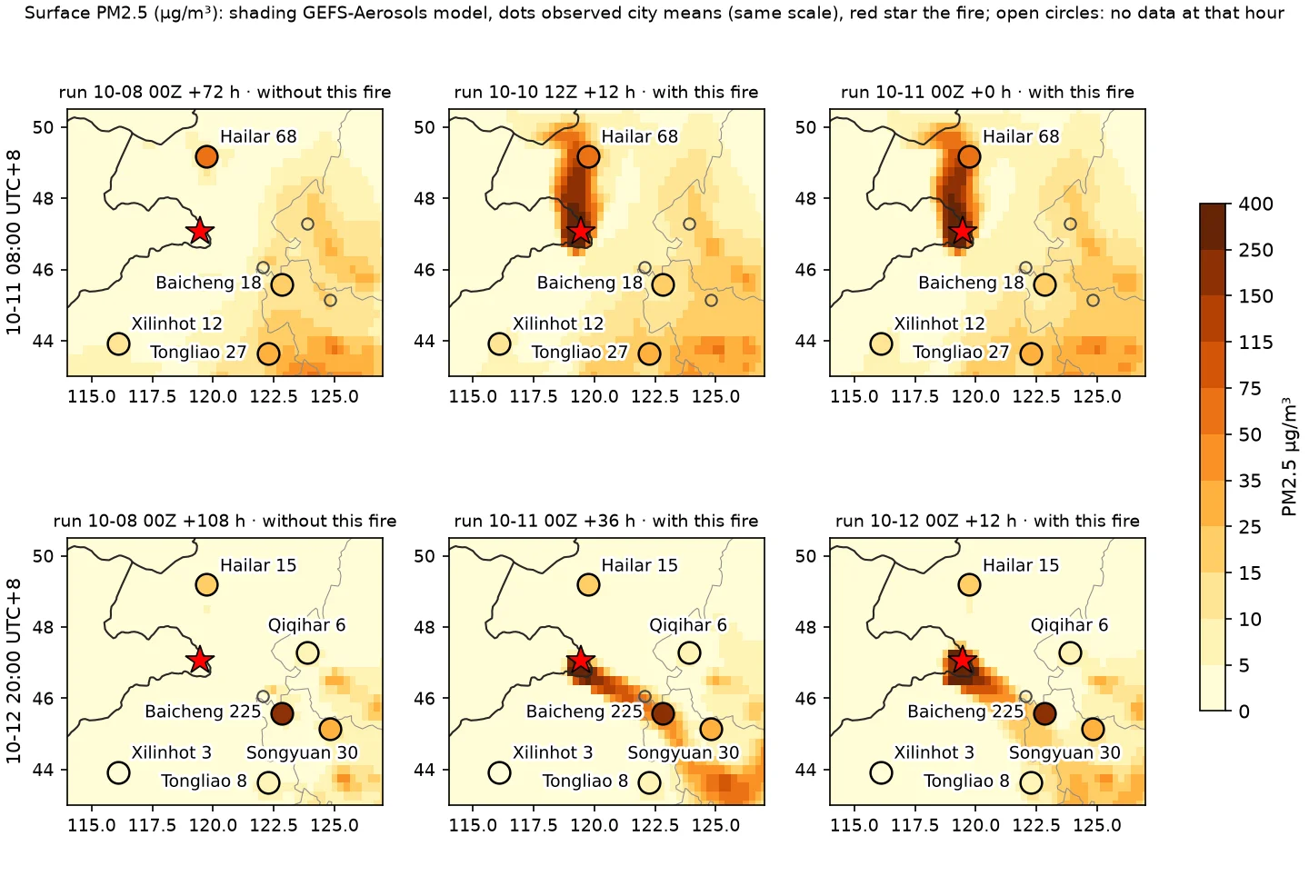
Hourly observed PM2.5 (black) and CO (blue, right axis) at Hailar and Baicheng, with GEFS-Aerosols model PM2.5 (bilinear at the city, 3-hourly). Dashed line: the run without this fire; orange lines: the four runs that include it.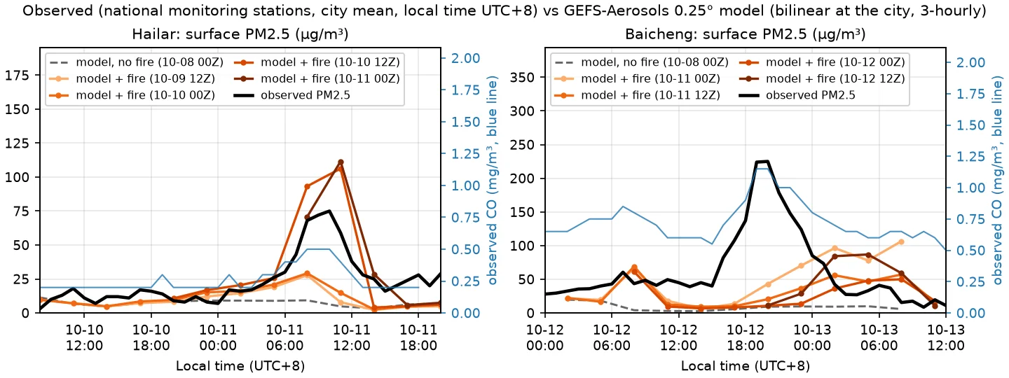
- Hailar: the two with-fire runs initialized at 10-10 12Z and 10-11 00Z give 93 and 106 µg/m³ at 08:00 and 71 and 112 µg/m³ at 11:00 on 10-11, with the smoke plume moving due north from the fire area over Hailar. The observations are 68 µg/m³ at 08:00, a peak of 75 at 10:00 and 59 at 11:00, with a pre-peak average of 13 µg/m³. The peak timing agrees, and the modeled magnitude is 1.0–1.5 times the observed value. The earlier runs of 10-09 12Z and 10-10 00Z, whose fire emissions were still small, give only 28–29 µg/m³. The no-fire control gives 9 and 5 µg/m³.
- Baicheng: in all four with-fire runs, the smoke plume runs southeast from the fire area through Ulanhot to Baicheng, in the same direction as observed, but it reaches the city grid point late and weak. At 20:00 the model gives 11–43 µg/m³ (observed 225), at 23:00 14–70 (observed 124), and at 02:00 on 10-13 36–96 (observed 42). The model maximum within 50 km of the city is 23–56 at 20:00 and 66–167 at 02:00. The model smoke plume is 3–9 hours late and 2–4 times weaker at the city. The plume is only one or two 0.25° grid cells wide, so a position error of one cell changes the value at the city several-fold. The no-fire control gives 6–10 µg/m³.
- Share within the model: the difference between the with-fire runs and the no-fire control is about 90–95% of the model PM2.5 at the Hailar peak, and about 85–90% after the plume reaches Baicheng. The model timing at Baicheng is late, so this share cannot be applied directly to the observed peak.
- Estimate from observations (my own calculation): with the few hours before the peak as background (Hailar 13 µg/m³, Baicheng 08:00–15:00 average 44 µg/m³), the part above background is 83% and 80% of the peak, and 80% and 71% of the peak-period average. With the weekly median as background (11 and 16 µg/m³), it is 85% and 93% of the peak. The Baicheng background of 44 µg/m³ may already contain smoke: the two with-fire runs have a small peak of 60–70 µg/m³ around 06:00 on 10-12, compared with about 20 µg/m³ in the no-fire control.
- Inference: about 70–90% of each of the two peaks came from smoke from this fire. The effect of the shallower nighttime boundary layer combined with local emissions has not been quantitatively ruled out.
- Model limitations: GEFS-Aerosols does not assimilate AOD. Fire emissions enter about 1.5 days late, as daily values without a diurnal cycle, and the injection height is parameterized. A 0.25° grid is coarse for a narrow smoke plume. In a separate evaluation of this model’s data (2026-09, against the same national monitoring stations), I found that its PM2.5 in Northeast China averaged about 0.6 times the observations, and that some pollution events were missed.
Official and media statements:
- 10-11, notice from the Arxan border crossing scenic area, issued by the Arxan Culture and Tourism Group (reposted by ifeng.com on 10-1220): “Due to temporary border controls, the border crossing scenic area is suspending operations as of today.” (因边境临时管控,口岸景区即日起暂停营业。)
- 10-12, a staff member of Arxan Forest Park told Southern Metropolis Daily21 that the park is “currently operating normally” (目前正常营业), “but you can still smell smoke, though the smell is not as strong as in the previous two days; earlier you could see smoke drifting over, and now there is less” (但还是能闻到烟味,不过味道已经没有前两天那么大了,早前还能看到飘过来的烟雾,现在小一点了).
- Fan Aijun of the Xilin Gol League Emergency Management Bureau (CCTV Finance 10-1322): “Dense smoke from the fire intermittently drifted with the wind to our country’s border areas, and in some areas inside the country smoke could be seen and smelled, but the open flames did not cross the national border and have not yet caused direct losses on our side such as damage to forest and grassland resources or casualties.” (火情产生的浓烟随风向间歇性飘至我国边境沿线,境内局部区域可见烟雾、闻到烟味,但明火未越过国境线,尚未造成我方森林草原资源损毁、人员伤亡等直接损失。)
The visibility drop at Arxan station on 10-11 falls within the “previous two days” (前两天) in which, according to the Southern Metropolis Daily quote of 10-12, smoke could be seen and smelled.
New fires on 10-22 in western Hulunbuir and eastern Mongolia
From the afternoon of 10-22, FIRMS detected four new fire areas in western Hulunbuir and eastern Mongolia. There were no fire pixels at the same locations from 10-16 to 10-21, so these fires started on 10-22; the satellites do not show what started them. Within 46–48°N, 118–121°E, the box around the Nömrög fire, the last fire pixels were those Terra detected at 19:19 on 10-15 at the separate fire south of the main fire area, and there have been none in the 7 days since. The new fires are 172–337 km from the Nömrög burn scar, with no fire pixels in between, and are unrelated to the Nömrög fire.
The table lists FIRMS VIIRS (S-NPP, NOAA-20, NOAA-21) and MODIS fire pixels up to 04:59 on 10-23, my own calculation.
| First detection | Location | Extent | Fire pixels | Distance from Nömrög scar |
|---|---|---|---|---|
| 10-22 12:44 | Sükhbaatar and Dornod provinces, Mongolia | 46.42–46.61°N, 114.29–114.46°E | 179 | 337 km |
| 10-22 12:46 | South of Hulun Lake, China | 48.44–48.65°N, 117.29–117.66°E | 589 | 172 km |
| 10-22 14:25 | Western New Barag Right Banner, China | 48.73–49.18°N, 116.03–116.84°E | 1,215 | 255 km |
| 10-23 01:39 | Mongolia, east of the previous Mongolian fire | 46.40–46.57°N, 114.82–115.22°E | 567 | 280 km |
- The fire south of Hulun Lake is about 57 km from the China–Mongolia border. By OSM administrative boundaries, all 589 fire pixels are in Bogd Uul Sum (宝格德乌拉苏木), New Barag Right Banner. The Beijing News quotes the sum government on the evening of the 22nd: 「现场起火的主要是捆草。火已被扑灭,无人员伤亡,起火具体原因和损失正在调查核实中。」 (what caught fire at the site was mainly baled hay; the fire has been put out, there were no casualties, and the cause and losses are being investigated)23. Note: there was no satellite pass between Aqua at 16:01 on 10-22 and 00:58 on 10-23; the 7 passes from 00:58 to 03:53 on 10-23 still detected fire pixels here, 426 in total, with the count per pass rising from 5 to 136 and the extent moving east from 117.42°E to 117.66°E, about 18 km. Inferred: the government’s statement that the fire was out may refer only to the baled-hay fire, or to the situation before it spread overnight.
- The fire in western New Barag Right Banner was about 5 km from the China–Mongolia border at first detection. All its fire pixels are on the Chinese side, split by OSM administrative boundaries across Dalai Sum, Altan Emeel Town and Arkhashaat Town of New Barag Right Banner, and it spread about 50 km east overnight. These border distances use the Natural Earth line, which in the Nömrög section differs from the OSM line by a median of 2.2 km and up to 4.4 km; the error here is also a few km.
- West of the New Barag Right Banner fires, at 115.7–116.0°E, 48.7–49.0°N, there is a reddish-brown burn scar that was already present on the 10-21 imagery and has had no fire pixels since 10-16, so it does not belong to these fires. Its southeastern edge is a straight line that follows the China–Mongolia border. Inferred: it was left by an earlier fire on the Mongolian side that burned up to the border. NSMC reported on 10-09 that FY-4C detected a fire at 115.77°E, 48.88°N at 03:00 UTC on 10-07 (11:00 UTC+8); the page calls it the ’northern fire’ and says it spread from northwest to southeast between 11:00 and 13:40 UTC+81. This position lies within the scar, consistent with the inference above. I did not check the extent of this 10-07 fire against other satellites.
- Near Manzhouli, at 49.62°N, 117.78°E, there are another 17 fire pixels about 10 km from the China–Russia border; at the precision of the Natural Earth line, which side they are on cannot be determined.
Open-Meteo model values (not observations): on 10-22 southerly winds of 25–45 km/h, gusts of 50–70 km/h and afternoon relative humidity of 22–35%; on 10-23 the wind turns westerly with gusts of 62–73 km/h.
The daytime VIIRS passes on 10-22 came just after these fires started, and the imagery did not yet show a contiguous new burn scar. In the daytime imagery of 10-23 the new scars are contiguous.
NOAA-21 VIIRS false colour around 12:25 BJT on 10-23. Magenta outlines: new burn scars in the 10-23 imagery, merged from the Terra and NOAA-21 scenes. Yellow and red dots: FIRMS fire pixels on 10-22 and 10-23 (Beijing dates), up to 13:18 BJT on 10-23. Cyan outline: the Nömrög (Numrug) scar of 10-12. White dashed lines: shortest distance from each new scar edge to the Nömrög scar, which differs from the fire-pixel distances in the table above. Solid yellow: OSM border; dashed yellow: Natural Earth border. Most of the two Mongolian fires lie under thin cloud and smoke, so their outlines cover only the visible part. Sources: NASA GIBS Corrected Reflectance, NASA FIRMS, OpenStreetMap, Natural Earth; scars mapped by the author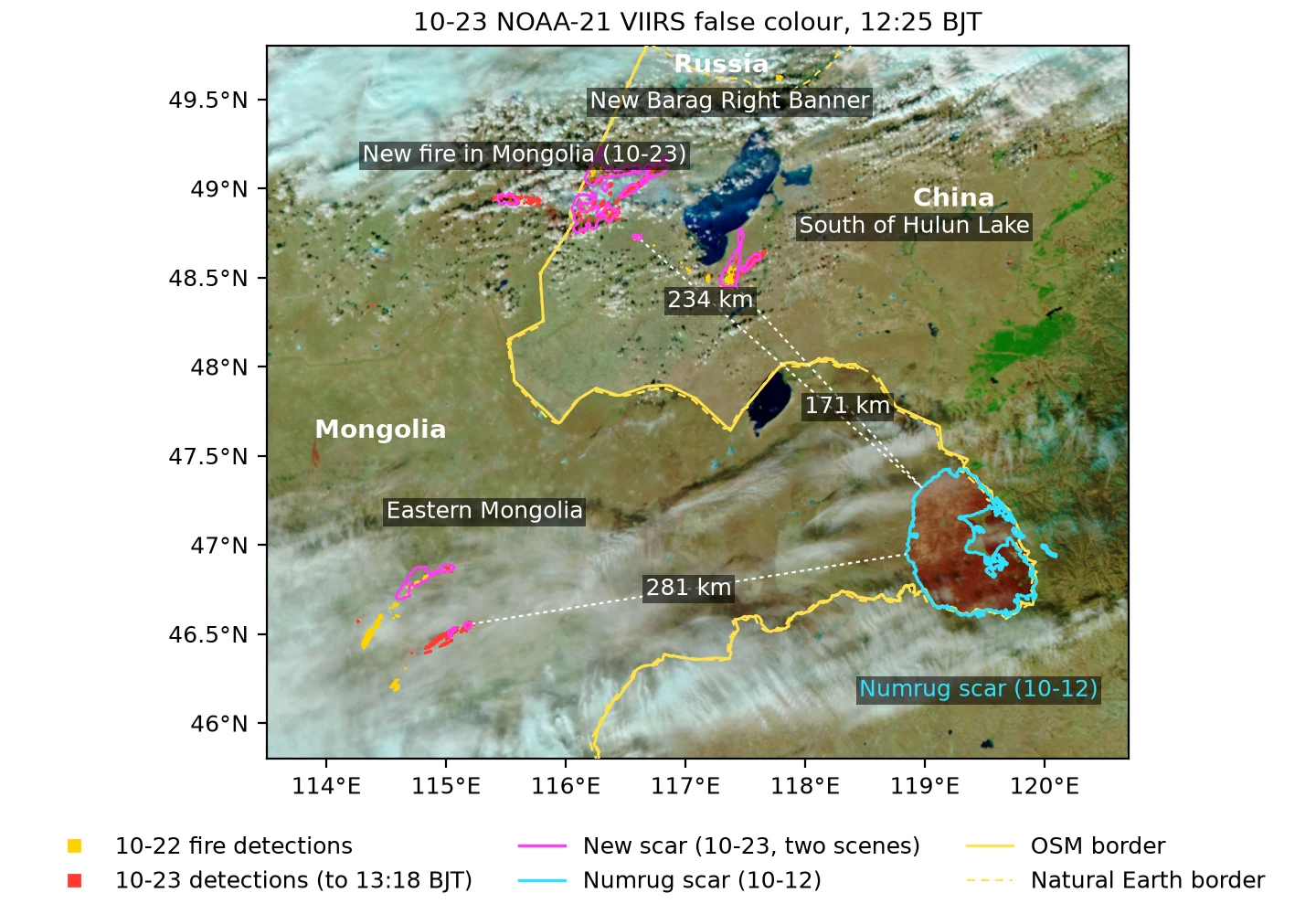
Close-up of the New Barag Right Banner fire (48.6–49.35°N, 115.3–117.2°E). Top left: NOAA-21 VIIRS on 10-21, with the first daytime fire pixels of 10-22 in yellow; the other three panels: Terra (10:06 BJT), NOAA-21 (12:25) and NOAA-20 (11:45) on 10-23. Cyan: the scar already present on 10-21, on the Mongolian side and not part of this fire. Magenta: new scar on 10-23, merged from Terra and NOAA-21. The fire at 115.4–115.8°E on the left is a new fire on the Mongolian side that appeared on the morning of 10-23. Sources: NASA GIBS, NASA FIRMS, OpenStreetMap, Natural Earth; scars mapped by the author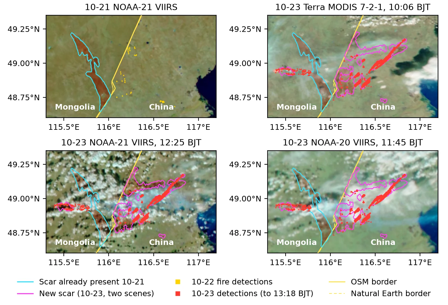
The burned areas are my own calculation from three scenes on 10-23: Terra at 10:06, NOAA-20 at 11:45 and NOAA-21 at 12:25, with pixels of about 250×370 m. These new scars are light brown or pinkish brown and lie under thin smoke, and the usual threshold (green < 75) does not pick them up. Instead I used the increase in the red/green ratio from 10-21 to 10-23 on the same sensor, removed the scar already present on 10-21, and kept only patches connected to FIRMS fire pixels. The error is about ±15%, larger under thin smoke.
| Fire | Terra 10:06 | NOAA-21 12:25 | NOAA-20 11:45 | Burned area |
|---|---|---|---|---|
| Western New Barag Right Banner | 388 km² | 426 km² | 135 km² (north half under cloud) | about 540–700 km² |
| South of Hulun Lake | 173 km² | 172 km² | 176 km² | about 175 km² |
| Two fires in Mongolia | 237 km² | 49 km² (mostly under cloud) | no data | at least about 240 km² |
| Mongolia, started 10-23 | 0 | 56 km² | 101 km² | 50–100 km² |
- In New Barag Right Banner the two scenes are obscured by smoke in different places: Terra misses the northern strip and NOAA-21 misses the middle. Their union is 699 km². South of Hulun Lake the three single scenes give 172–176 km², but the union of two is 228 km², so the union overcounts by about 30% from misregistration; applying that to New Barag Right Banner gives a lower bound of 699 × 0.77, about 540 km².
- For the two Mongolian fires only the Terra scene is usable, and most of the area is under thin cloud and smoke, so 237 km² is a lower bound.
- The western edge of the new scar in New Barag Right Banner runs along the OSM China–Mongolia border, with only 2–3 km² beyond the line. Along 300 km of border, one VIIRS pixel width is 75–110 km², so 2–3 km² is within the pixel error and does not show that the fire crossed the border. All fire pixels on 10-22 and on the night of 10-23 are also east of the OSM line.
- On the morning of 10-23 a new fire started on the Mongolian side at 48.83–48.96°N, 115.39–115.78°E, west of the scar already present on 10-21 and 20–48 km from the China–Mongolia border. There were no fire pixels here from 10-16 to 10-22. FIRMS has 6 fire pixels from Terra at 10:06, 84 from NOAA-20 at 11:45 and 33 from NOAA-21 at 12:25, so it was still burning at noon. The old burned scar lies between it and the Chinese fires, at least about 18 km apart, and on 10-23 the wind was westerly, so fire spreading west from the Chinese side would have moved against the wind. Inferred: a separate ignition or rekindling at the edge of the old scar; the satellites do not show the cause.
- Measured from the new scar edges, the shortest distances to the Nömrög scar are 171 km south of Hulun Lake, 234 km in New Barag Right Banner, 281 km and 320 km for the two Mongolian fires, and 308 km for the new Mongolian fire.
FIRMS up to 13:18 on 10-23: on the Chinese side in New Barag Right Banner each daytime pass has only 1–9 fire pixels, and south of Hulun Lake none; the two Mongolian fires have only 2 fire pixels, from NOAA-21 at 12:25.
Confidence in the conclusions
| Conclusion | Confidence | Basis |
|---|---|---|
| Ignition time 10-08 11:41–11:51 | Medium-high | The two geostationary satellites, Himawari and GK-2A, agree independently, and the warming at 11:50–11:51 exceeds the background; a 2 km pixel is insensitive to a very small early fire |
| Ignition time and location | High | Several satellites agree independently: Sentinel-2C about 30 minutes before ignition shows no fire, and Himawari, GK-2A and VIIRS then detect it in turn; the ignition date and location in the Mongolian official reports agree |
| Open flames mostly stopped, residual burning inside the Mongolian fire area | High | From 10-13 to 10-15 each overpass had 1–31 pixels and FRP of no more than 1.3 GW, about 90–97% less than the same overpass on 10-12, all in the unburned island in the middle of the Mongolian fire area and at its edge; consistent with the Xinhua report of 10-13 |
| Main fire out on the afternoon of 10-15 | High | The last fire pixels are 1 pixel from S-NPP at 13:48 and 4 pixels from Aqua at 14:52; after that, about 30 VIIRS overpasses through 10-18, and MODIS through 20:23 on 10-18, had no fire pixels; the fire area was clear in three scenes on 10-16 |
| Burned area about 4,900 km², no growth after 10-14 | Medium-high | Recalculated from two fully clear VIIRS scenes of 10-14; most of the increase is area hidden by smoke or missed by the threshold on 10-12; two fully clear VIIRS scenes of 10-16 give 4,898–4,915 km²; Sentinel-2 20 m dNBR of 10-20 gives about 4,850 km² after subtracting the unburned island, 4,540–5,015 km² for thresholds 0.10–0.27; the differences from the NMC’s 5,050 km² and the 5,288 km² of the Mongolian ministry’s preliminary estimate of 10-20 are within the range of area definitions; the Mongolian ministry’s official result of 10-28, from 10 m Sentinel-2, is 5,050 km², 0.05% from the 5,052 km² of the 10-20 Sentinel-2 main patch on the Mongolian side |
| About 79% of the Nömrög Strictly Protected Area burned, consistent with Mongolia’s 79.8% | Medium-high | WDPA reserve polygon overlaid on the 10-20 Sentinel-2 main patch: 4,497 km² inside the reserve, 4% less than the 4,690 km² of Mongolia’s preliminary estimate of 10-20 and 0.2% from the 4,490 km² (76.4%) of the official result of 10-28; 64% counting burned pixels only; whether the WDPA polygon matches the boundary Mongolia used has not been checked |
| The small fire on the Chinese side south of the main fire is a separate ignition (inferred) | Medium | 3 MODIS fire pixels from Aqua and Terra coincide with the new burn scar on 10-16 VIIRS, and no scar was present on 10-14 under clear sky; Sentinel-2 on 10-20 shows a scar of 13 km², about 9 km long, whose ends coincide with the fire pixels; about 60 km from the residual fire that day; the ignition time can only be estimated roughly, and the cause is unknown |
| On 10-15 the fire line on the southern edge of the unburned island was burning north (inferred) | Low to medium | One Sentinel-2C scene; 5 clusters of saturated pixels at the boundary between old burn scar and unburned grass, 0.03–0.42 km from the fire pixels of three VIIRS overpasses that day; the northern half of the unburned island is cloud-covered |
| No contiguous burned area entering China | High | The 10-20 Sentinel-2 main patch has 67 km² on the Chinese side, all within 3.6 km of the line; after 10-13 all FIRMS fire pixels and Himawari hotspots of this fire are on the Mongolian side; consistent with the Xinhua reports |
| About 21 km² burned on the Chinese side in the south section, with a main patch of about 13 km² | High | Supported by three independent sources: Sentinel-2 on 10-10 (10 m) and 10-20 (20 m), and VIIRS |
| The burned area in the south section is from Chinese backburning | Medium | Consistent with the backburning operations reported publicly by the East Ujimqin Banner authorities; burned at night under calm, humid conditions with a southerly wind; the image shape alone cannot distinguish the cases, and the backburning locations and times have not been published. No new burning on 10-13 Sentinel-2B |
| About 11.5 km² burned on the Chinese side of the section west of Arxan, up to 2.2 km from the line | Medium-high | Sentinel-2 on 10-20 is about 70% clear on the Chinese side; the burned band matches the fire pixels that crossed the line on 10-12; the 0.9 km² seen on 10-13 is its northern end |
| The northern patch west of Arxan is fire that crossed the border and was stopped by the backburn firebreak (inferred) | Low to medium | The eastern edge of the burned area stops at the river valley inside the border; Hinggan League reports backburning along the border patrol road from 12:40 on 10-11; the backburn strip is not resolved in the 10-13 imagery, and most of the area east of the northern cluster is cloudy |
| Whether the burned band west of Arxan is fire from Mongolia or Chinese backburning | Low | On 10-20 the band is continuous with the Mongolian scar and 0.5–2 km wide, wider than the reported hundred-metre buffer; both causes leave the same scar shape, and the backburning locations and times have not been published |
| The drop in visibility at Arxan on 10-11 came from smoke | Medium | Visibility fell to 3.9 km with haze reported under a dry southwest wind, consistent with the Xilin Gol League statement that “dense smoke intermittently drifted with the wind to our country’s border areas” (浓烟随风向间歇性飘至我国边境沿线); Arxan has no air-quality station |
| The PM2.5 peak at Baicheng on the evening of 10-12 contains smoke from this fire | Medium-high | The satellite smoke plume, the back trajectories at three levels and the arrival time agree; the smoke plume in the GEFS-Aerosols with-fire runs follows the fire area–Ulanhot–Baicheng line, but 3–9 hours late and 2–4 times weaker at the city, with a no-fire control of 6–10 µg/m³; no large fire pixels within about 100 km, and a local contribution cannot be fully excluded |
| The PM2.5 peak at Hailar on the morning of 10-11 contains smoke from this fire | Medium-high | The peak timing of the GEFS-Aerosols with-fire runs agrees with the observations, with a magnitude 1.0–1.5 times the observed value and a no-fire control of 5–9 µg/m³; supported by the low-level trajectories and TROPOMI carbon monoxide; the airflow at 850 hPa and above does not pass over the fire area |
| About 70–90% of the two peaks came from this fire (inferred) | Medium | The observed part above the pre-peak background is 80–83% of the peak, and the with-fire part within the model is 85–95%; the Baicheng model smoke plume is late, and the nighttime boundary layer and local emissions have not been quantitatively ruled out |
| The 10-22 fires in western Hulunbuir and eastern Mongolia are unrelated to the Nömrög fire | High | No fire pixels within 46–48°N, 118–121°E in the 7 days after 19:19 on 10-15; the new fires are 172–337 km from the Nömrög scar with no fire pixels in between; no fire pixels at the same locations from 10-16 to 10-21 |
| The new scar in New Barag Right Banner on 10-23 is about 540–700 km² and did not cross the border | Medium | Own calculation from the red/green change in three VIIRS/MODIS scenes, each obscured by smoke in different places; lower bound scaled by the agreement of three scenes south of Hulun Lake; the 2–3 km² beyond the line is within the pixel error, and all fire pixels are on the Chinese side |
The Sentinel-1 backscatter change has been tried (track 149, four dates: 09-07, 09-19, 10-01 and 10-13, UTC). Between 09-19 and 10-13 the whole scene drops, and VH falls by 3.5–4 dB both inside the scar and on unburned ground, so the two cannot be separated. Between 10-01 and 10-13, VV falls by 2.3 dB inside the scar and 1.0 dB on unburned Mongolian ground, but also by 1.7 dB on unburned ground on the Chinese side. The areas with the largest drop do not follow the scar edge, and the pre-fire pair 09-07 and 09-19 shows the same pattern. Freeze–thaw, moisture and grass phenology outweigh the burn signal, and Sentinel-1 cannot check the burned bands near the border. The cause of the drop is inferred and has not been checked.
The following observations would change the assessments above:
- If the location and time of the backburning on the East Ujimqin Banner section and the exact locations of the backburning in each Hinggan League sector are published, the causes of the burning in the south section and of the narrow strip west of Arxan can both be determined.
Sources and acknowledgments
Fire data are current to 2026-10-18 20:23 (MODIS) and 10-18 14:00 (VIIRS), and high-resolution imagery to 10-20 11:11.
- Fire detections: NASA FIRMS near-real-time active fire data: VIIRS (S-NPP, NOAA-20, NOAA-21) C2 375 m and MODIS (Terra, Aqua) C6.1 1 km (MOD14/MYD14), from 10-04 onward. Data and imagery from NASA LANCE/FIRMS and GIBS/Worldview.
- VIIRS 375 m L2 active fire: NASA LP DAAC (VNP14IMG, VJ114IMG, VJ214IMG v002) and the LANCE near-real-time versions, which use the same algorithm as FIRMS; used for the fire spread animation and the overpass statistics from the afternoon of 10-15 onward. L2 overpass times are granule start times and differ from FIRMS times by a few minutes; for example, the first overpass after ignition is at 12:08 in FIRMS and at 12:06 in L2.
- Terrain: Copernicus DEM GLO-90 © DLR e.V. 2010–2014 and © Airbus Defence and Space GmbH 2014–2018, provided under COPERNICUS by the European Union and ESA; obtained via the AWS open data registry, used for the animation base map.
- Himawari-9 AHI L1b: Observed by the Japan Meteorological Agency (JMA), distributed by NOAA on AWS (noaa-himawari9), and reprojected for this post. Full disk; B07 (3.9 µm) and B14 (11.2 µm) at 2 km, one frame every 10 minutes; B01–B04 true color, with B03 red at 0.5 km. Used to 10-13 22:00, plus 10-14 13:00–15:00.
- GK-2A AMI L1B: Observed by the Korea Meteorological Administration (KMA, 128.2°E), distributed by NOAA on AWS (noaa-gk2a-pds). Full disk; 3.8 µm at 2 km and 0.64 µm at 0.5 km, every 10 minutes; used only for the period around ignition on 10-08.
- VIIRS L1B: NASA LAADS DAAC (VNP02/03, VJ102/103, VJ202/203); the first three overpasses after ignition on 10-08 (NOAA-21, S-NPP, NOAA-20), I bands at 375 m, plus M-band true color at 750 m for NOAA-21.
- Sentinel-2 L2A: Contains modified Copernicus Sentinel data 2026, obtained via Element84 Earth Search. 10/20 m; six scenes, on 10-05, 10-08, 10-10, 10-13, 10-15 and 10-20 (two overpasses on 10-20, Sentinel-2B at 10:57 and Sentinel-2A at 11:11). The 10-13 11:15 scene has extensive cumulus: about 56% of the Chinese side of the south section and about 77% of the Chinese side of the section west of Arxan are covered by cloud or cloud shadow. The 10-15 11:05 scene (Sentinel-2C) is cloudier: 99–100% of the Chinese side of the south section and of the section west of Arxan is cloud-covered, and so is about 90% of the unburned island in the middle of the fire area, of which only the southern edge is visible.
- Sentinel-1 RTC: Contains modified Copernicus Sentinel data 2026, obtained via Microsoft Planetary Computer (sentinel-1-rtc). Sentinel-1C, descending track 149, VV/VH, four dates (09-07, 09-19, 10-01, 10-13), processed at 40 m.
- Protected area boundary: UNEP-WCMC and IUCN (2026), Protected Planet: The World Database on Protected Areas (WDPA), October 2026, Cambridge, UK: UNEP-WCMC and IUCN. Available at: www.protectedplanet.net. Nömrög Strictly Protected Area, WDPA site ID 93518.
- Landsat 9 C2 L2: Landsat 9 image courtesy of the U.S. Geological Survey, obtained via Microsoft Planetary Computer. 30 m; one scene on 10-08.
- Daily MODIS/VIIRS imagery: NASA GIBS, 250–375 m, 10-07 to 10-18. The three scenes of 10-13 are cloudy, 10-14 and 10-16 are fully clear, 10-15 has cloud over the southern half of the fire area, 10-17 is fully cloud-covered, and the western half of the fire area is clear on 10-18.
- Sentinel-5P TROPOMI L2: Contains modified Copernicus Sentinel data 2026, obtained via NASA GES DISC. Carbon monoxide total column and UV aerosol index, 10-09 to 10-12, quality flag ≥ 0.5. Aerosol optical depth uses the MODIS MAIAC product from NASA GIBS.
- ECMWF IFS and AIFS open data (CC BY 4.0): IFS 0.25° from the 10-13 00Z run and AIFS from the 10-13 06Z run; the back trajectories use hourly IFS 0.25° winds. ECMWF does not endorse derived products.
- IFS HRES 0.1°: Via Open-Meteo (CC BY 4.0), 10-13 00Z run.
- NOAA NCEP GFS 0.25°: 10-13 06Z run.
- NOAA GEFS-Aerosols: Chemistry version of GEFSv12, control forecast, 0.25°, 3-hourly, with fire emissions from GBBEPx, obtained via AWS open data (noaa-gefs-pds); runs initialized from 10-08 00Z to 10-12 12Z.
- Open-Meteo forecast and historical forecast APIs (CC BY 4.0): used for the hourly series at the fire area and for the CMA-GRAPES (CMA) and ICON (Deutscher Wetterdienst) point forecasts (both 10-13 06Z).
- FY-4C hotspots: From the CMA National Meteorological Centre bulletin of 10-12 19:00, and from the NSMC FY Emergency Support page of 10-09.
- Model fields, soundings and fire products: Read from the public STAC catalog of Xue.
- Soundings: CMA, via WIS2, WMO Unified Data Policy. Hailar, Xilinhot, Tongliao and other stations, to 20:00 on 10-13.
- Surface weather reports: SYNOP from both sides of the China–Mongolia border, 10-07 to 10-13, obtained via Ogimet. The Chinese stations are automatic and report weather phenomena only when phenomena are present; the visibility code has an upper limit of 30 km.
- Air quality: National real-time city air-quality release of the China National Environmental Monitoring Centre, obtained via the quotsoft.net mirror, hourly, 10-07 to 10-14. Hinggan League (Ulanhot, Horqin Right Front Banner) has had no data in the mirror for a long time, and Arxan City has no national monitoring station.
- Border and administrative boundaries: © OpenStreetMap contributors (ODbL, openstreetmap.org/copyright). The comparison border line on the Himawari and wide-area figures is made with Natural Earth. The border on the weather maps and the Chinese county-level (ADM3) administrative boundaries come from geoBoundaries (CC BY 4.0); the latter are used to determine which league and banner the burned area on the Chinese side belongs to.
- Online viewers:
- Fire replay: fire pixels, NOAA-21 false color and GFS winds: VIIRS/MODIS fire pixels from 10-08 to 10-15, with 10 m wind, gusts, temperature and dew point from the GFS 10-08 00Z run
- Fire replay: Himawari-9 10-minute infrared: 3.9 µm and 10.4 µm, 120 hours from 08:00 on 10-08, with the same fire pixels; press H in the right panel to show hotspots
- Himawari true color
- ECMWF 10 m wind
- Related post: Satellite Observation of the China–Nepal Border Debris Flow, an earlier post in the same format: public satellite data on an event at a border, there with Sentinel-1 and NISAR radar instead of optical and thermal imagery.
- Code: The data processing and plotting scripts for this post are at ringsaturn/numrug-fire-2026, MIT license.
National Satellite Meteorological Centre (NSMC), 10-09: FY Emergency Support page for international users on disaster prevention and mitigation, “Wildfire in Mongolia”, in English; FY-4C monitoring of the ’northern fire’ on the northern section of the China–Mongolia border on 10-07 (115.77°E, 48.88°N) and the ‘southern fire’ on 10-08 (119.40°E, 46.87°N), with a fire pixel area time series and thematic maps ↩︎ ↩︎ ↩︎ ↩︎
NEMA 10-12: call received at 11:55 on 10-08; location Бичигтийн-Өндөр ↩︎
Mongolian legal-entity registry (opendatalab.mn): Mobicom’s shareholder is KDDI Overseas Holdings B.V. ↩︎
ikon.mn 10-12: full text of the Mobicom statement; a vehicle caught fire during the handover of telecommunications work and caused a grassland fire ↩︎
Eguur.mn 10-14: the General Authority for Border Protection statement from the entry permits onward; border-zone entry permits for 13 people and 5 vehicles for 10-06 to 10-08; the fire was caused by the carelessness of people who entered the border zone; law enforcement agencies are investigating ↩︎
nutag.mn 10-17: a working group of the Dornod Province police department began investigating the cause of the fire ↩︎
NEMA 10-16: completely extinguished at 07:00 on 10-16 ↩︎
Montsame 10-12: Eastern Regional Emergency Management Department; ignition on 10-08, ignition location, burned extent of 96 km west–east and 82 km south–north ↩︎
Montsame English edition, 10-20 17:12: “Massive Wildfire Damage in Numrug Reserve to Be Assessed”; Minister of Environment and Climate Change Sandag-Ochir Tsend in Khalkhgol soum; preliminary estimate of 528,765.5 ha burned, 468,965.7 ha (79.8%) inside the protected area ↩︎ ↩︎ ↩︎
Montsame 10-28 10:00: “Нөмрөгийн түймэрт өртсөн талбайн хэмжээг албан ёсоор тогтоов” (“Burned area of the Nömrög fire officially determined”); official determination by the Ministry of Environment and Climate Change: of the protected area’s 587,744.1 ha, 448,993.6 ha burned (76.4%), 55,966.8 ha outside the protected area, 504,960.4 ha in total, based on Sentinel-2 10 m imagery, mapped by an institute under the National Agency for Meteorology and Environmental Monitoring ↩︎ ↩︎
Xinhua 10-11: a fire broke out inside Mongolia along the border of East Ujimqin Banner around 13:00 on October 9; more than 2,000 people deployed section by section; the fire had not entered China as of 21:00 on the 11th ↩︎
Xinhua 10-13: more than 3,400 people deployed to block the fire; the grassland fire did not cross the border; as of 11:00 on the 13th, intermittent fire lines remained only in parts of the Mongolian side ↩︎ ↩︎
NMC, Global Severe Weather Monitoring and Forecast Bulletin, 10-12 19:00: “Current fire situation on the China–Mongolia border and weather and risk forecast for the next three days” (《中蒙边境火情实况及未来三天天气及风险预报》), with a burned area of about 5,050 km² estimated by satellite remote sensing. The page is a column page that switches between issues; the 2026/10/12 19:00 issue has to be selected on the page ↩︎
Southern Weekly 10-18 (WeChat account): “Blocking the grassland fire: a test by fire on the China–Mongolia border” (《阻截草原火:中蒙边境上的“烤”验》), reporter Liu Jialun, intern Jiang Siqi; the Arxan City Forestry and Grassland Bureau firefighting team crossing the border to fight the fire, backburning originally scheduled for 10-10, Bao Yulong’s burned-area estimate ↩︎ ↩︎
The Beijing News 10-11: fire glow beyond the Arxan border crossing; the Arxan City Emergency Management Bureau and the Hinggan League Fire and Rescue Mobile Detachment confirmed that the ignition point is outside China ↩︎
Hinggan Forestry and Grassland, 10-16 (WeChat): 《鏖战七天七夜 坚守北疆防线——兴安盟成功堵截蒙古国草原靠境大火》 (“Seven days and nights of fighting, holding the northern frontier line: Hinggan League successfully blocks the Mongolian grassland fire approaching the border”), from the League Forest and Grassland Fire Prevention Station; watchtower sighting at 12:15 on 10-08, force deployment, 131 km of counter-burning from 10-11, artificial snow enhancement on the night of 10-13, no smoke or fire at 13:00 on 10-15 ↩︎ ↩︎
Xinhua Inner Mongolia 10-14: “Wuchagou Forestry Bureau of Hinggan League makes every effort to stop the grassland fire from entering” (《兴安盟五岔沟林业局全力阻截草原火入境》), reporter En Hao; 21 km of firebreak backburned by “fighting fire with fire”, in under 2 hours ↩︎
National Forestry and Grassland Administration 2025-11-04: a 131 km firebreak along the China–Mongolia border in Hinggan League, 100–300 m wide ↩︎
CNR Xilin Gol 10-12: fire north of Mandubaolige town, 100 m firebreak, backburning continued ↩︎
Arxan border crossing scenic area notice 10-11 (reposted by ifeng.com on 10-12): operations suspended due to temporary border controls; source: Arxan Culture and Tourism Group ↩︎
Southern Metropolis Daily 10-12: Arxan Forest Park operating normally; smoke can still be smelled ↩︎
CCTV Finance 10-13 (WeChat account): Fan Aijun of the Xilin Gol League Emergency Management Bureau, “the open flames did not cross the national border” (明火未越过国境线); backburning carried out from the firebreaks ↩︎
Hongguan News 2026-10-22 23:00, reprinting The Beijing News: “内蒙古一草场发生火灾,现场烟雾弥漫,火势连成一片,当地政府:起火的是捆草,火已被扑灭,无人员伤亡,具体原因和损失正在调查核实中”. I could not find the Beijing News original ↩︎